System and method of detecting and navigating to empty parking spaces

a parking space and parking system technology, applied in the field of location-based navigation, can solve the problems of driver still, vehicle operator on a fruitless quest, prior art systems of only limited help to vehicle operators,

Active Publication Date: 2011-03-01
GAMBA GRP HLDG LLC
View PDF19 Cites 75 Cited by
  • Summary
  • Abstract
  • Description
  • Claims
  • Application Information

AI Technical Summary

Benefits of technology

[0085]The system overcomes the anxiety of “Where will I park” (or return to parking RTP) by providing the ability to locate a space in advance from your Bluetooth enabled device or your cell phone with our parking detector application.
[0116]More over, our innovation can solve the “RTP” (Return to parking) problem, where many forget where they parked their car. The system has an option to save the location on the “cellular phone—parking detector” application, which will make it easy to locate the parked car.

Problems solved by technology

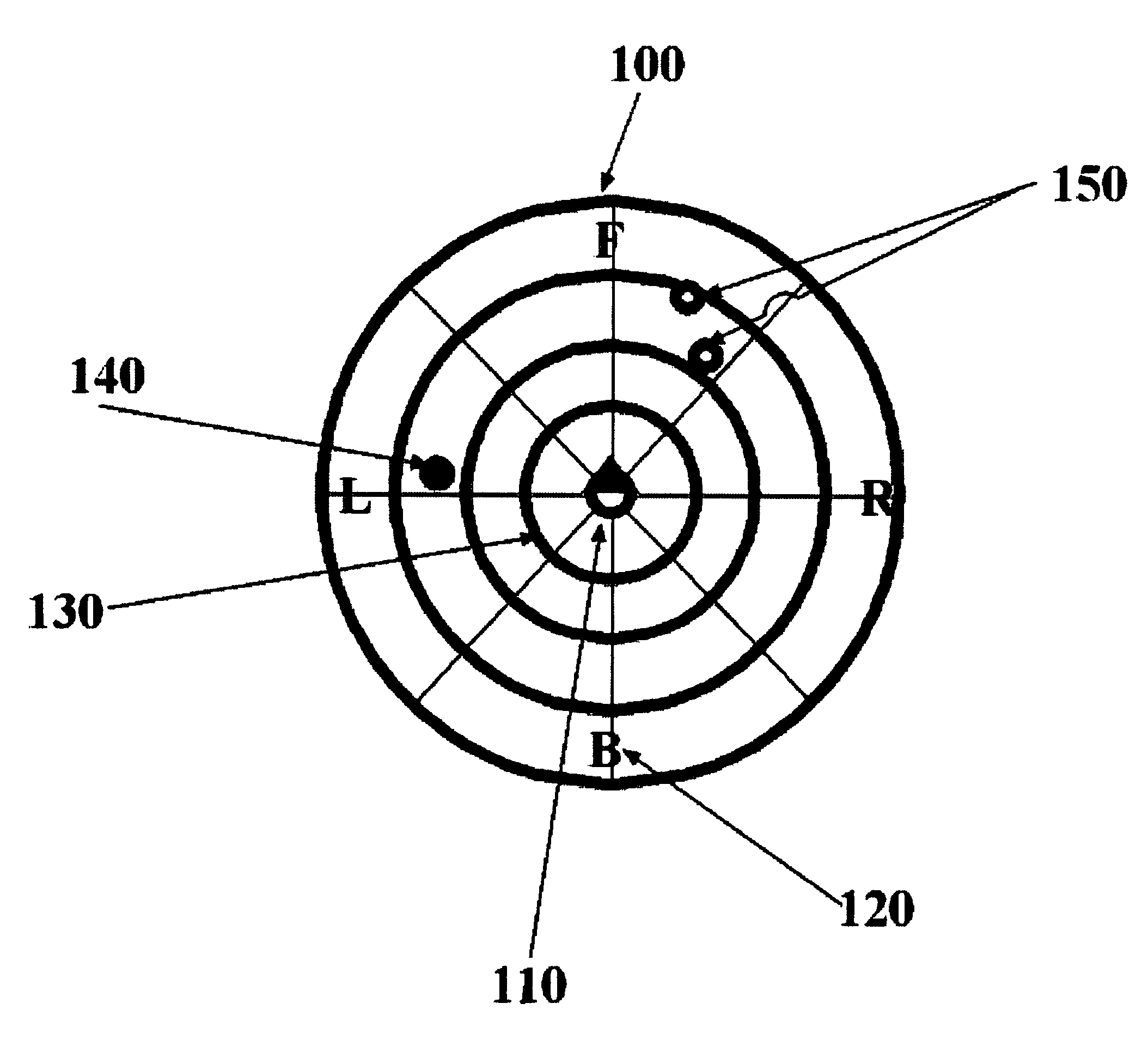
However, because the driver seeing a parking available signal is not advised of the number and specific location of parking spaces that are available in that block, the vehicle operator may proceed to the indicated location to find that a single available space has already been occupied or that the space will not accommodate his vehicle.
In either situation, the binary availability signal may lead the vehicle operator on a fruitless quest.
Unfortunately, such systems again only yield a binary yes or no signal to the drivers.
Even if an area contains only one available space, even if the space is obstructed, will not accommodate the driver's car, or is otherwise undesirable, a driver still will be lead to that area.
These prior art systems are of only limited help to vehicle operators and do not resolve many concerns associated with parking an automobile.
This vehicle navigational system patent does not address the problem of locating available on-street parking.
Parking lots in congested city areas are not very cost effective, and they may not be in close proximity to the driver's destination.
Because the technique described operates over a wireline medium, it does not lend itself to being easily deployed in a wide area.
Also, because parking information is never provided to any device within a vehicle, drivers still need to navigate through a garage to locate available spaces.
At present, there is no on-board vehicle navigational system that delivers accurate and real time parking space information directly from the vehicle or ether portable phone application upon entering a specific geographic area.
Schreder does not disclose sub-meter vehicle location accuracy determination
However, it is unclear as to whether the second position system is actually more accurate than the GPS system.
This combined system, however, cannot be used for sub-meter positioning of an automobile.
This procedure does not give sub-meter accuracy.
This is based on the fact that the GPS signals used by Kyrtsos do not contain a differential correction and the selective access feature is on Locating a vacant parking space is an ordeal that causes frustration for many commuters.
Even if a commuter pays to enter a parking lot, valuable time is consumed searching for a parking space within the parking lot.
It seems that parking lots that service hospitals, airports, mass transit stations, entertainment forums, shopping malls and the like are always the most crowded, when time is the most crucial.
As urban and suburban regions become more populated, finding a vacant parking space will become increasingly difficult for commuters.
At present, however, no prior art device utilizes the capabilities to display a real-time representation of available parking spaces directly from the sensors without central system.
Again, most of the existing prior arts are base ether on a GPS system or ether the existing car navigator (depend on a GPS to), and the existing mapping that they use has the same limitation as describe before and therefore practically can't be implements and work.
Other parking projects exist but they do not approach our innovation in ability to deliver a complete solution to the parking problem.
Other projects address the issue from the perspective of a parking garage and do not consider street parking, nor are they really concerned to facilitate the location of an empty space inside their garage.
They do not provide the driver with the ability to compare prices in the vicinity.
TOA considered to be the most accurate method, because multipath effects can be filtered out, Yet, it is considerably more complex to implement, as it requires a modified hardware on the mobile side, as well as special modifications on the antenna side.
By finding the intersection of few such direction vectors, a mobile's position can be estimated AOA is considerably less accurate than TOA, due to limited angular resolution and the fact that indoor much of the signal is reflected.
Also, AOA antennas are more complex, as they require multi-section, highly directional antennas, and multiple RF circuitry.
Such solutions do exist in the market, providing an accuracy of about 2 m. One limitation of such systems is the fact that WLAN tags are relatively bulky and power hungry.

Method used


Image

  • System and method of detecting and navigating to empty parking spaces
  • System and method of detecting and navigating to empty parking spaces
  • System and method of detecting and navigating to empty parking spaces

Examples


Embodiment Construction

[0145]In all the figures of the drawing, sub-features and integral parts that correspond to one another bear the same reference symbol in each case:

[0146]Referring now to the figures of the drawings in details and first particularly to FIG. 1-5 thereof. There is shown an illustration of the method and system to detect and navigate to empty parking spaces.

[0147]The method contain the floating overlay display 100, a real-time floating overlay omni-directional circular display to overcome the limitations of the GPS based systems and the existing mapping systems.

[0148]The “user” will have easy way to figure out the distance and the direction to the empty parking spaces without GPS or any mapping.

[0149]The empty parking spaces will be displayed inside the graphical real-time omni-directional circular display in such way that the “user” will intuitively determine the distance and the direction to the empty parking spaces.

[0150]Each parking spaces will be shown with a simple color code to ...


PUM


Abstract

The parking detection system method described herein could guide people around urban environments detect guide and navigate them to empty parking spaces, add-on to the car-based navigation systems and or to the cellular phone. We have focused on the task of detecting and navigating even in situations in which Global Positioning Systems (GPS) cannot provide this information, such as when the person is indoors or in crowded urban areas where there is no line of site to the GPS satellites and without the need for central computer system or internet connections. The parking information will be received directly from RF sensors and will display as a floating overlay on the existing navigation system and or cellular phone as Bluetooth application.

Description

RELATED APPLICATIONS[0001]This application is a Non-Provisional Application, claiming the benefit of U.S. Provisional application No. US60 / 670,097 filed Apr. 12, 2005, which is incorporated herein in its entirety.FIELD OF THE INVENTION[0002]This invention is directed generally to the field of location based navigation and, more particularly, to such systems and the method to be used in detecting and navigating to empty available parking spaces.BACKGROUND OF THE INVENTION[0003]Location based services are rapidly expanding. Outdoor location technologies are mainly based on GPS technologies. GPS does not perform properly indoors, and is not adequate; recently, as a result, indoor location systems are appearing on the market.[0004]The need for a system such as ours stems from various market segments and applications. One example, in the market for integrated positioning and navigation systems using GPS receivers as their primary positioning technology, is the “Car navigator”.[0005]Howev...

Claims


Application Information

Patent Timeline
Patent Type & Authority Patents(United States)
IPC IPC(8): G06F17/00H04W4/02H04W4/024
CPCG08G1/14G01C21/00H04B7/24G06Q20/327G07B15/00G01C21/206G01C21/3685G07B15/02H04W4/025G06Q30/0261G08C17/02H04B7/26G07F17/246G07F9/001G07F9/009H04W4/02G01S5/04H04W64/006H04W88/02H04W4/024
Inventor MENDELSON, EHUD
Owner GAMBA GRP HLDG LLC
Why Eureka
Try Eureka