Sun tracking system and implementing method based on GPS and GIS

A technology of sun tracking and GPS module, applied in the field of sun tracking system based on GPS and GIS, can solve the problems of insufficient vertical light reception and low tracking accuracy of the daylighting device, and achieve the effect of improving use efficiency, reducing consumption and reducing environmental pollution.

Inactive Publication Date: 2008-07-23
郭卫平
View PDF4 Cites 18 Cited by
  • Summary
  • Abstract
  • Description
  • Claims
  • Application Information

AI Technical Summary

Problems solved by technology

[0006] The purpose of the present invention is to provide a sun tracking system based on GPS and GIS and its implementation method, which can effectively solve the problems of insufficient vertical light receiving and low tracking accuracy of the daylighting device, so that the daylighting device can maintain the verticality with the direction of sunlight in real time, In order to improve the tracking accuracy of the system and the use efficiency of solar energy

Method used


Image

  • Sun tracking system and implementing method based on GPS and GIS
  • Sun tracking system and implementing method based on GPS and GIS
  • Sun tracking system and implementing method based on GPS and GIS

Examples


Embodiment Construction

[0018] The present invention will be further described below in conjunction with FIG. 1 to FIG. 5 and embodiments.

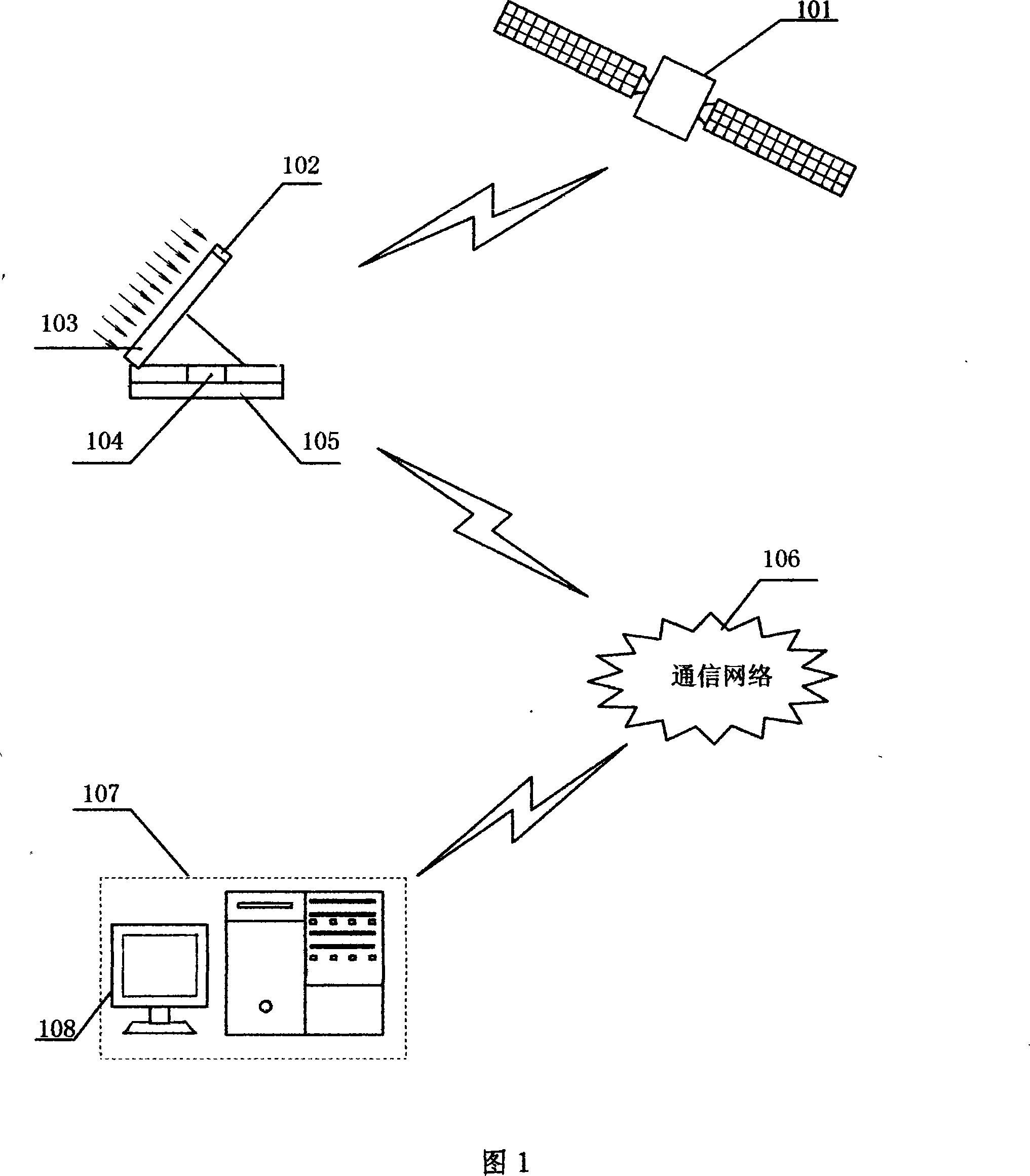
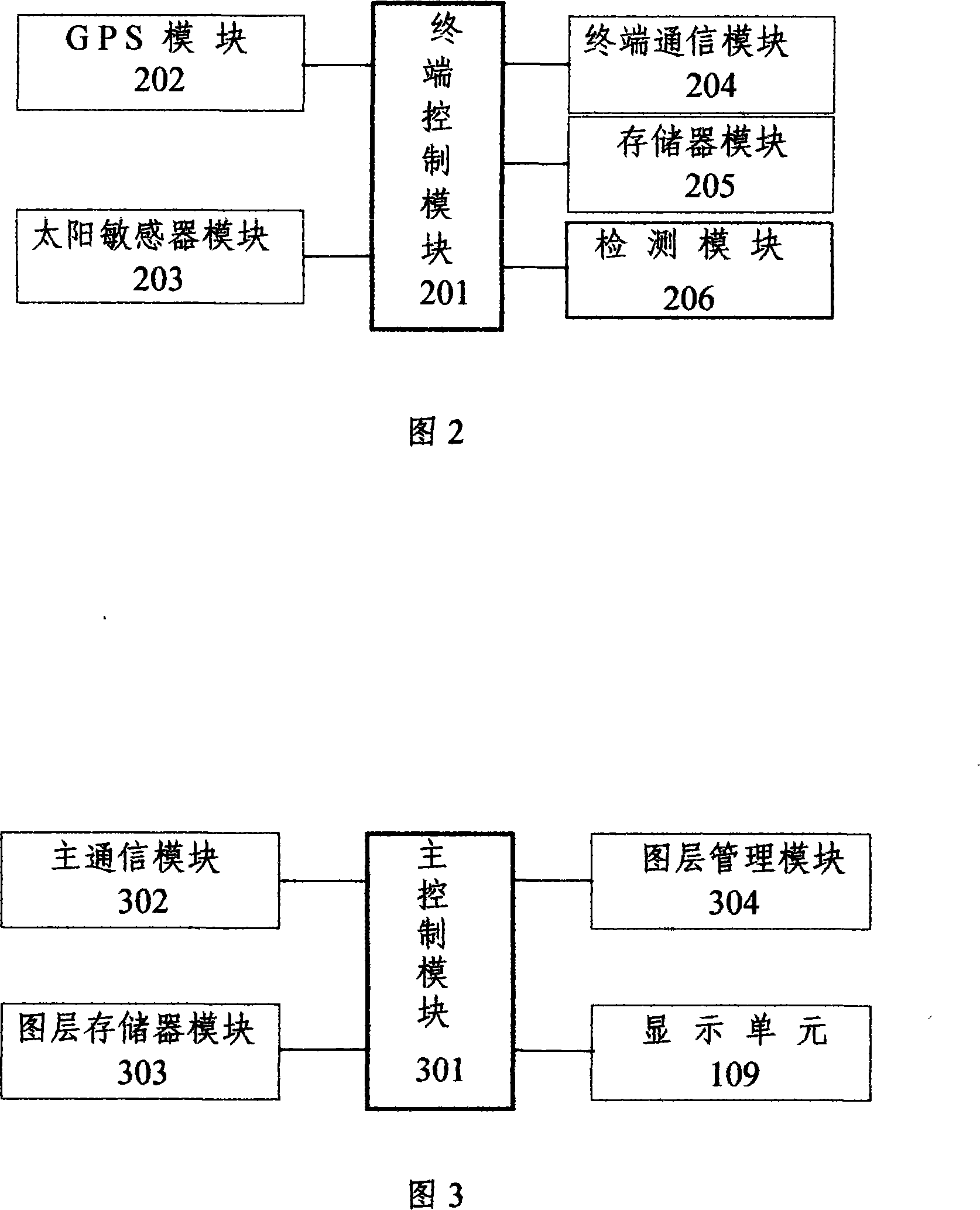
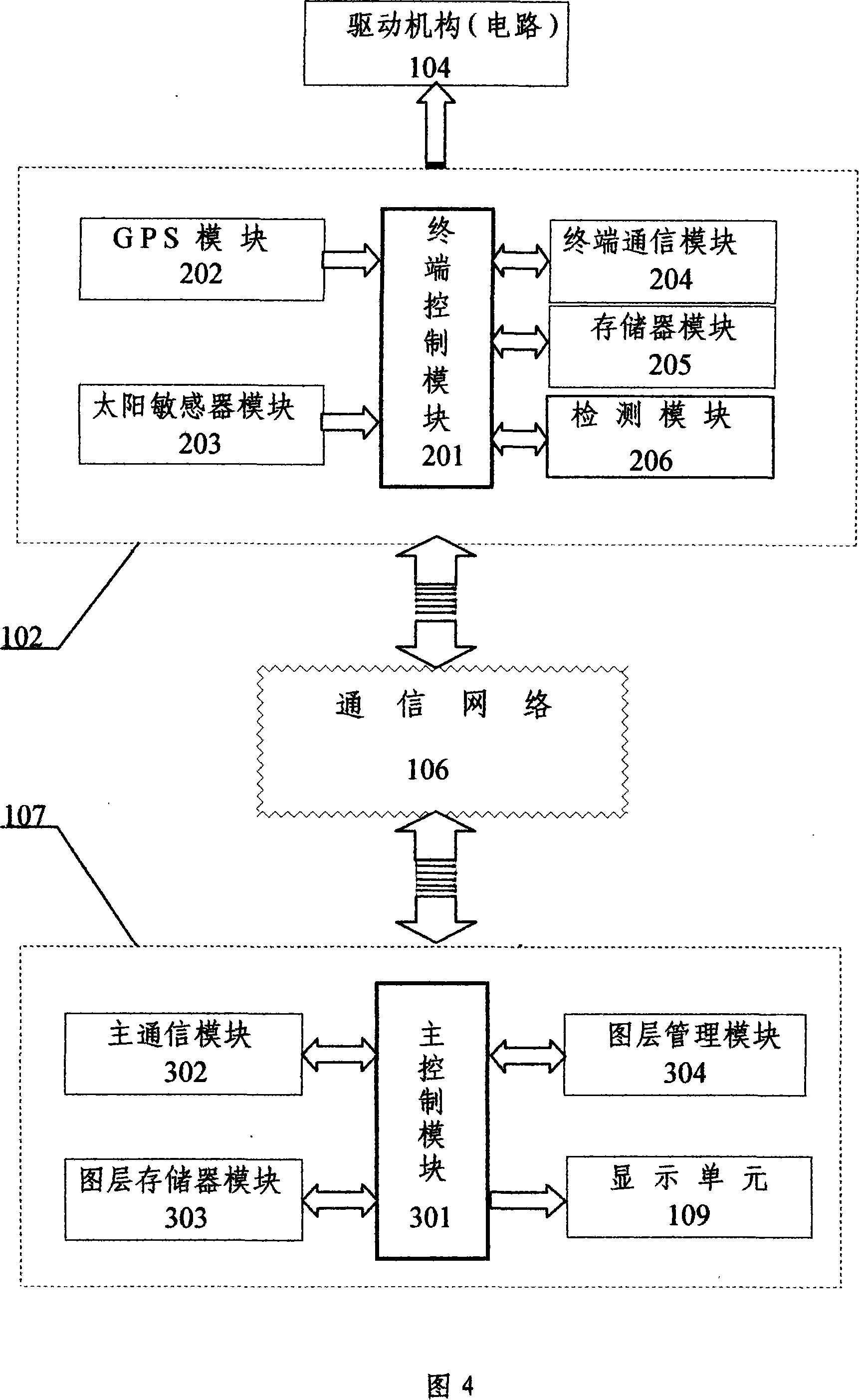
[0019]Firstly, the present invention will be described with reference to FIGS. 1 to 4 . Select a GPS module (202) and a digital sun sensor module (203) with a wide operating temperature range, and connect them to the terminal control module (201) respectively through a standard interface. After that, select the GMS / GPRS wireless communication module as the terminal communication module (204), select the DDR4 type memory as the memory module (205), and select the monitoring circuit as the detection module (206). In fact, the terminal control module (201) is an 8-bit microcontroller and processor, and the memory module (205) and the detection module (206) are embedded together with the terminal control module (201), thereby forming a daylighting control system. terminal (102). Then the daylighting control terminal (102) is fixed on the daylighting device (103), ...


PUM


Abstract

The invention relates to a sun track system based on GPS and GIS and a relative method, which uses a lighting control terminal and a detection control center to control the sun track system and automatically track sun. The lighting control terminal controls variable control modules, a GPS terminal, a sun sensor module, a terminal communication module, a memory module and a detection module which are all connected with a terminal control module and mounted on the lighting control terminal. The detection control center comprise a plurality of control terminals, a main communication module, a layer memory module and a layer management module which are all connected with the main control module and mounted on the detection control center. The invention can enable the sun track device to accurately track sun, effectively improve solar energy application efficiency, reduce traditional energy consumption and reduce environment pollution, with automatic positioning, correction, detection and error report.

Description

technical field [0001] The invention belongs to the technical field of solar energy utilization, in particular to a sun tracking system based on GPS and GIS and its realization method. Background technique [0002] GPS is the Global Positioning System (Global Positioning System), which is a satellite measurement system composed of 24 satellites covering the whole world. GPS can ensure that 4 satellites can be observed at any point on the earth at any time at the same time, so that the satellite can collect the longitude, latitude and altitude of the observation point, so as to realize functions such as navigation, positioning, and timing. Due to the all-weather, high-precision and automatic measurement characteristics of GPS technology, as an advanced measurement method and new productivity, it has been integrated into various application fields of national economic construction, national defense construction and social development. GPS is one of the most pioneering high-te...

Claims


Application Information

Patent Timeline
Patent Type & Authority Applications(China)
IPC IPC(8): G05D3/12G01S5/02G01C21/02G05B23/02H02N6/00F24J2/38F24S50/20G01S19/42H02S40/44
CPCY02E10/47Y02E10/60Y02E10/50
Inventor 郭卫平
Owner 郭卫平
Why Eureka
Try Eureka