Vehicle mounted investigation method and system of large scale crops planting area

A large-scale, crop-based technology, applied in surveying, mapping and navigation, measuring devices, instruments, etc., can solve the problems of large influence of human factors, insufficient data objective, satellite data accuracy is not suitable for autumn grain crops, etc., to improve survey accuracy and reduce The effect of labor intensity

Active Publication Date: 2009-01-21
ACADEMY OF PLANNING & DESIGNING OF THE MINIST OF AGRI +1
View PDF0 Cites 15 Cited by
  • Summary
  • Abstract
  • Description
  • Claims
  • Application Information

AI Technical Summary

Problems solved by technology

[0003] At present, my country mainly obtains the planting area information of large-scale crops in the country through the ground sampling of the Bureau of Statistics and the level-by-level statistical reporting of the Ministry of Agriculture. It is greatly affected by human factors and the data is not objective enough.
Although remote sensing yield estimation is timely and objective, the acquisition of remote sensing image data is greatly affected by weather, which has the following disadvantages: ①In practice, the accuracy of satellite data is not suitable for distinguishing intercropping autumn grain crops; ②The acquisition of remote sensing image da

Method used


Image

  • Vehicle mounted investigation method and system of large scale crops planting area
  • Vehicle mounted investigation method and system of large scale crops planting area
  • Vehicle mounted investigation method and system of large scale crops planting area

Examples


Embodiment Construction

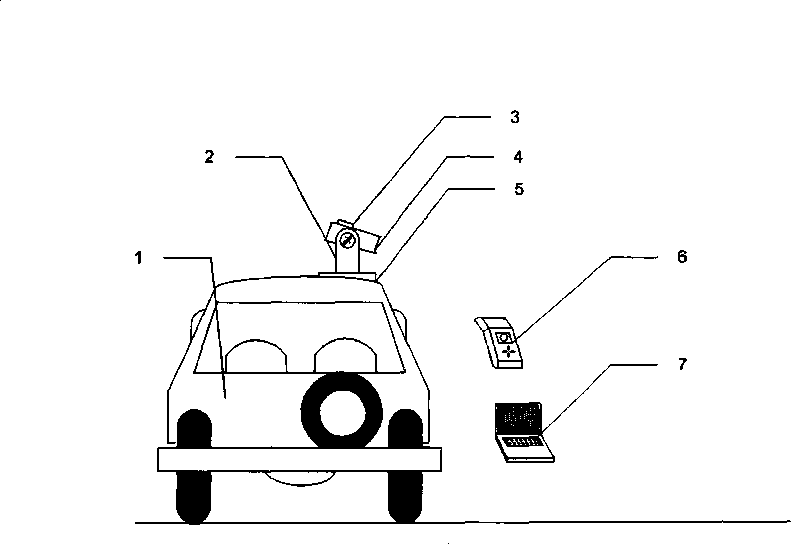
[0017] Please refer to figure 1 , Install the pan-tilt on the right side of the roof, install the CCD camera and tilt sensor on the pan-tilt, and load the GPS receiver and notebook computer in the car. The hardware model and parameters are shown in Table 1.

[0018] Table 1 System hardware model and parameter list

[0019]

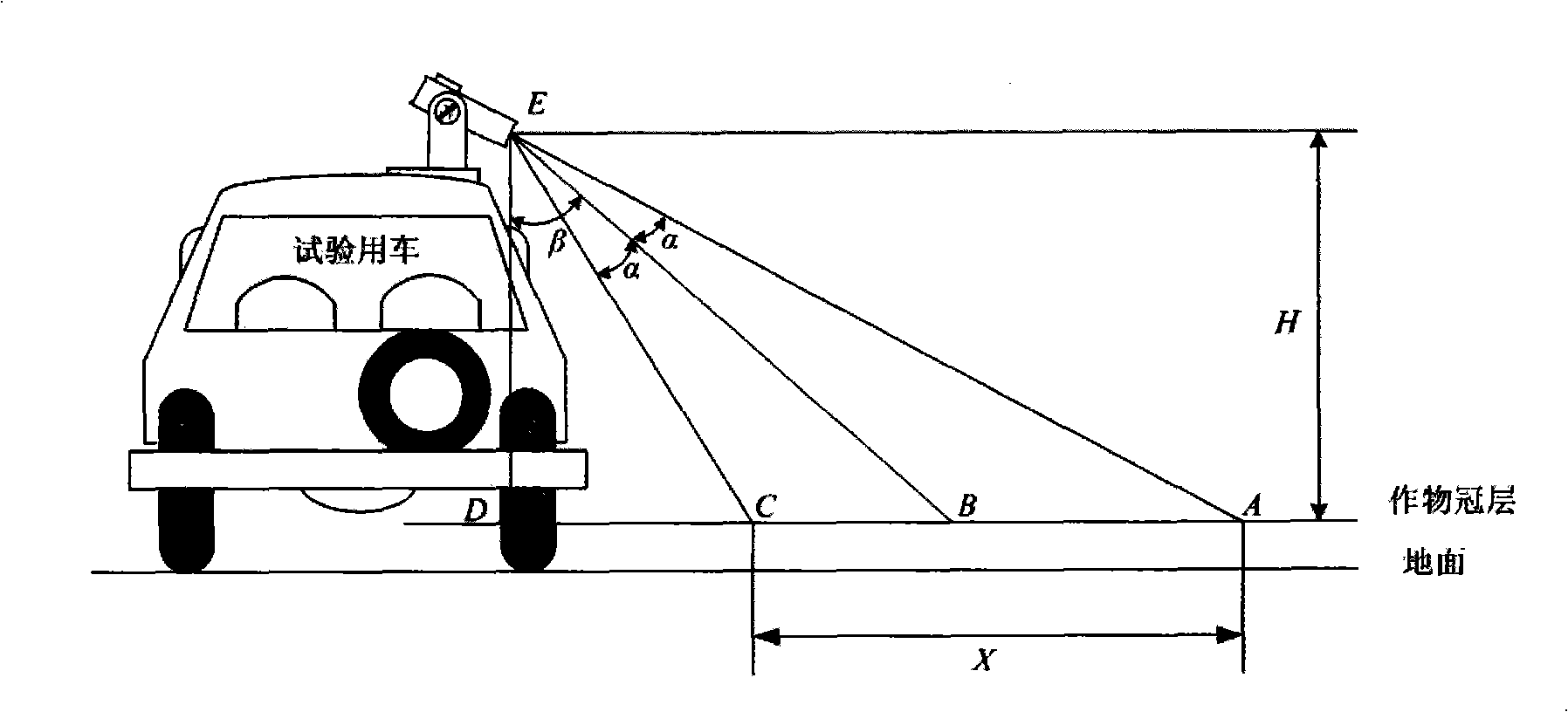
[0020] Please refer to figure 2 , the camera is installed on a pan-tilt whose attitude can be controlled, and the shooting angle can be controlled through the pan-tilt; the inclination sensor is fixed on the camera and swings with the camera, and the vehicle roll angle measured by the inclination sensor is the swing angle of the camera corresponding to the vertical field of view .

[0021] Please refer to image 3 , EB is the optical axis of the camera; points C and A are the near point and far point of the vertical field of view of the camera respectively; ∠AEC is the vertical field angle of the camera, ∠AEC=2α; β is the optical axis of the camera...


PUM


Abstract

The invention discloses a large scale crop plant area vehicle-carrying investigation process and a system thereof, which comprises the matching of GPS position information and a GIS map, the matching of GPS position information and images, the decision of crop longitudinal plant width, the storage and extraction of the images, the grid algorism of the images, the identification of crop species, the storage of GPS position information and the various crops plant information and the calculation of various crops plant area and plant quotas. The process and the system can realize the drawing of vehicle navigation and path line through the GPS position information, measure the shooting angle of a camera through a dip angle sensor and control the quadrat width of a sampling, realize the video storage of the sampling and the single-frame extraction of a to-be-identified image through the image collection, and increase the real-time and the accurate ratio of identification through the grid algorism of the images, and automatically calculate the plant areas of various large scale crops through the crop identification. The system provides three ways of hand-held function, automatic function and the video playback function to calculate the plant area of crops and the plant quota.

Description

field of invention [0001] The invention relates to a vehicle-mounted investigation method and system for large-scale crop planting area. Through the development, application and combination of GPS, GIS, image processing and image recognition technologies, the calculation of large-scale crop planting area and planting percentage is completed, and the classification is carried out. Save to the corresponding database. In particular, users can choose manual function, automatic function and video playback function to complete the calculation of crop planting area and planting percentage according to their needs, thus meeting the different needs of users. Background technique [0002] my country is a large agricultural country, and food security is a problem that our government attaches great importance to. Accurate forecasting of crop yields is of great significance for the formulation of national food policies, the development of rural economy, and foreign food trade. Under the...

Claims


Application Information

Patent Timeline
IPC IPC(8): G01C11/00G01C21/00
Inventor 杨邦杰毛恩荣焦险峰马蓉王素霞汪庆发宋正河裴志远张蕊
Owner ACADEMY OF PLANNING & DESIGNING OF THE MINIST OF AGRI
Why Eureka
Try Eureka