View spot triggering method based on explication point in GPS intelligent guide system

A technology for intelligent tour guides and commentary points, applied in the field of tour guide systems, can solve the problems of large amount of data triggered by scenic spots, large amount of data, and difficulty in transplanting, modifying, and querying triggering data of scenic spots, etc. small amount of effect

Inactive Publication Date: 2009-11-25
上海网悠科技有限公司
View PDF4 Cites 32 Cited by
  • Summary
  • Abstract
  • Description
  • Claims
  • Application Information

AI Technical Summary

Problems solved by technology

[0004] The invention patent published in 2002 (application number is CN00130764.9) "portable automatic tour guide playback device and automatic playback method" uses the method of comparing the GPS position coordinate signal with the scenic spot coordinate position to trigger the introduction of scenic spot information, which is different from the actual tour guide. The psychological needs of Chinese and Chinese tourists who want to hear the introduction of scenic spots when they see scenic spots in the distance are inconsistent, and the precise matching method is adopted. In the case of objective GPS positioning errors, it is easy to cause the problem that tourists have not started to explain after arriving at the scenic spot. In addition, there will be a problem that the sights are still triggered when obstacles block the sight of the sights
[0005] The invention patent published in 2007 (application number CN200610112317.X) "Mobile multimedia intelligent tour guide service system and its implementation method" is to judge whether the GPS position coordinate signal falls within the trigger area drawn in advance or not to trigger the scenic spot information Introduction, when drawing the trigger area, factors such as the shape, size, and topology of the trigger area need to be considered, and it needs to be represented by planar continuous data. The amount of data is large, which is not conducive to storage, data representation, and Conducive to the execution of attractions triggering algorithm
[0006] The invention patent published in 2007 (the application number is CN200610023772.2) "the method of using GPSPDA as an audio-visual tour guide" is suitable for the automatic search of scenic spots in a large range, but it is difficult for the user to ...

Method used


Image

  • View spot triggering method based on explication point in GPS intelligent guide system
  • View spot triggering method based on explication point in GPS intelligent guide system
  • View spot triggering method based on explication point in GPS intelligent guide system

Examples


Embodiment Construction

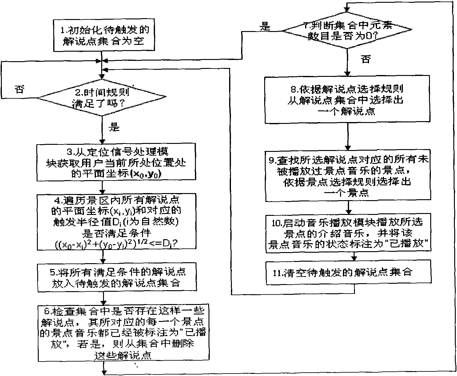
[0042] A method for triggering scenic spots based on commentary points in a GPS intelligent tour guide system, including the collection and triggering of data related to the commentary points, and the GPS positioning signal processing module to obtain the current user's position, direction, and speed information,

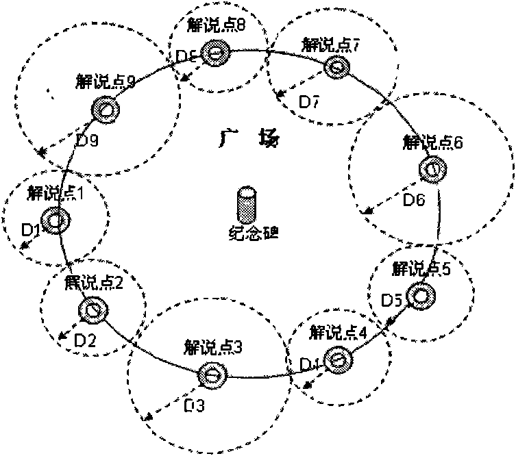
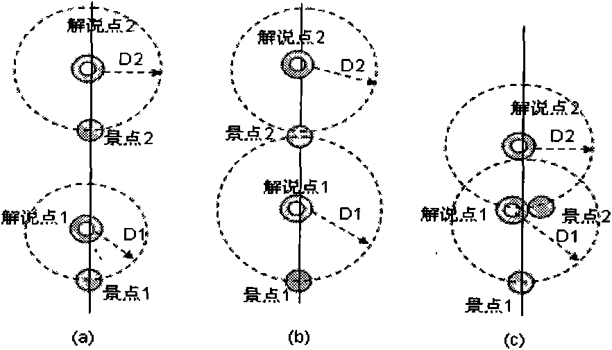
[0043] In the stage of collecting the relevant data of the interpretation point, the present invention uses a method for collecting the relevant data of the interpretation point. In this method, the relevant data of interpretation points are firstly defined. The so-called commentary point refers to the best position point on a certain path where a certain scenic spot should be explained from the perspective of a tour guide. Similar to the concept of POI points in the map, the commentary points also have various attributes, that is, the relevant data of the commentary points, which mainly include:

[0044] Commentary point coordinate attribute: It is used to represe...


PUM


Abstract

A view spot triggering method based on the explication point in a GPS intelligent guide system comprises: collecting and triggering the data correlated with the explication point, acquiring the position, direction and speed information of the current user by a GPS positioning signal processing module. The triggering steps comprise: searching whether all of the explication spots in the scenic zone meeting the triggering requirement according to the preset triggering cycle and the preset triggering radius, selecting an explication spot from the explication spot assembly based on the explication spot selection regulation, searching the view spot not playing the music and relative to the explication spot, selecting a view spot based on the view spot selection regulation and starting the music playing module. The data quantity or work quantity of the collected or mapped data is small. The view spot triggering data can be vectorized which is better than the mode of triggering the zone in an graphics mode. The explication point triggering mode is influenced by the number of the explication point and the triggering radius values, wherein the data quantity is small, the algorithmic complexity is low and the performance is high.

Description

technical field [0001] The invention relates to a tour guide system and method, in particular to a method for triggering scenic spots based on commentary points in a GPS intelligent tour guide system. Background technique [0002] At present, the positioning methods used in the intelligent tour guide system include: radio frequency positioning method, infrared positioning method, wireless communication network positioning method, satellite positioning method, etc. Among them, the satellite positioning method mostly uses GPS satellite positioning chip, which has the advantages of free positioning, wide positioning range, The advantages of high positioning accuracy, no need for additional hardware support, and small size are very popular, representing a development direction of intelligent tour guide systems. [0003] In the GPS intelligent tour guide system, in addition to the GPS positioning signal processing module, it is also necessary to use the scenic spot trigger module...

Claims


Application Information

Patent Timeline
IPC IPC(8): G09F25/00G01S5/02G06F17/30
Inventor 赵斯典
Owner 上海网悠科技有限公司
Why Eureka
Try Eureka