Image restoration method

An image, pixel-level technology, applied in the field of satellite image restoration based on MTF, which can solve the problems of unrealistic implementation and huge targets.

Inactive Publication Date: 2010-01-27
WUHAN UNIV
View PDF0 Cites 30 Cited by
  • Summary
  • Abstract
  • Description
  • Claims
  • Application Information

AI Technical Summary

Problems solved by technology

The sample comparison method is to compare and interpret the sample image with known MTF and the satellite remote sensing image, so as to determine the MTF of the remote sensing satellite; the landmark measurement method borrows from foreign methods, but it is suitable for higher resolution satellites, because If the resolution is low, the required targets will be very large and impractical to implement

Method used


Image

  • Image restoration method
  • Image restoration method
  • Image restoration method

Examples


Embodiment Construction

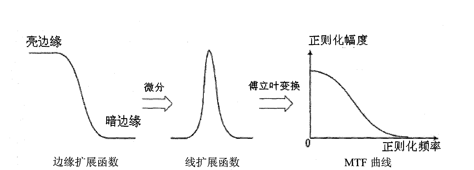
[0053] The present invention will be described in further detail below in conjunction with the accompanying drawings. In summary, the implementation of this method can be divided into four steps:

[0054] The first step: acquisition of modulation transfer function curve.

[0055] attached figure 1 The flow chart of calculating MTF for the knife-edge method, the specific steps are:

[0056] 1. Edge detection

[0057] First, make a simple difference for each row of pixel values, that is, calculate the gray level difference between every two adjacent pixels, find the position with the largest difference value, which is the pixel-level position of the edge, and use the values ​​of 4 points near this point to make a cubic polynomial curve Fitting, to determine its sub-pixel position, the fitting polynomial is:

[0058] a(n)=a 1 no 3 +a 2 no 2 +a 3 n+a 4 (1)

[0059] Among them, n is the position (column number) of the pixel point, and a(n) is ...


PUM


Abstract

An image restoration method based on MTF includes the following steps: firstly, calculating MTF curve of an image; secondly, constructing dimensional MTF matrix; thirdly, carrying out image restoration in frequency domain by utilizing the MTF matrix. The method aims at remote sensing image with large data volume and is based on MTF theory and image quality degradation theory; and the method provided by the invention is effective for image restoration. Practice shows that the method can effectively restore image and improve image quality and has high algorithm efficiency. Currently, the method is successfully applied in domestic ground satellite pre-treatment system, and practice shows that the method is correct, feasible and universal.

Description

technical field [0001] The invention belongs to the field of remote sensing image processing and relates to an MTF-based satellite image restoration method. This method combines the characteristics of TDI CCD imaging. In the case of few known imaging conditions, only the information of the remote sensing image itself is used to extract the MTF to effectively restore the image, further improve the clarity of the image, and enhance the visual effect of the image. It has the characteristics of simplicity, practicality and strong versatility. Background technique [0002] TDI CCD is currently the main detector type of a new generation of high-resolution imaging sensors at home and abroad. Although the application of TDICCD devices has indeed improved the spatial resolution of high-resolution satellite images in terms of physical hardware, due to various The actual resolution of the satellite image cannot reach the ground resolution originally designed by the sensor due to the i...

Claims


Application Information

Patent Timeline
Patent Type & Authority Applications(China)
IPC IPC(8): G06T5/10G06T7/00G01S7/497
Inventor 王密葛苹潘俊
Owner WUHAN UNIV
Why Eureka
Try Eureka