Method for simulating urban land use change

A simulation method and land technology, applied in the direction of calculation model, biological model, special data processing application, etc., can solve the problems of complex calculation process, difficult to grasp, lack of consideration of spatial correlation of urban land use change, etc., to achieve cellular Evolve and extend effects that are reasonable and accurate, improving effects and precision

Inactive Publication Date: 2012-08-01
WUHAN UNIV OF TECH
View PDF2 Cites 31 Cited by
  • Summary
  • Abstract
  • Description
  • Claims
  • Application Information

AI Technical Summary

Problems solved by technology

[0004] Based on the research status at home and abroad, the current simulation methods for urban land use change are mainly divided into two categories: (1) Mathematical statistics methods: such as Markov model, regression analysis model, statistical model, etc. These methods regard the land change process as random Transformation process, lack of consid

Method used


Image

  • Method for simulating urban land use change
  • Method for simulating urban land use change
  • Method for simulating urban land use change

Examples


Embodiment Construction

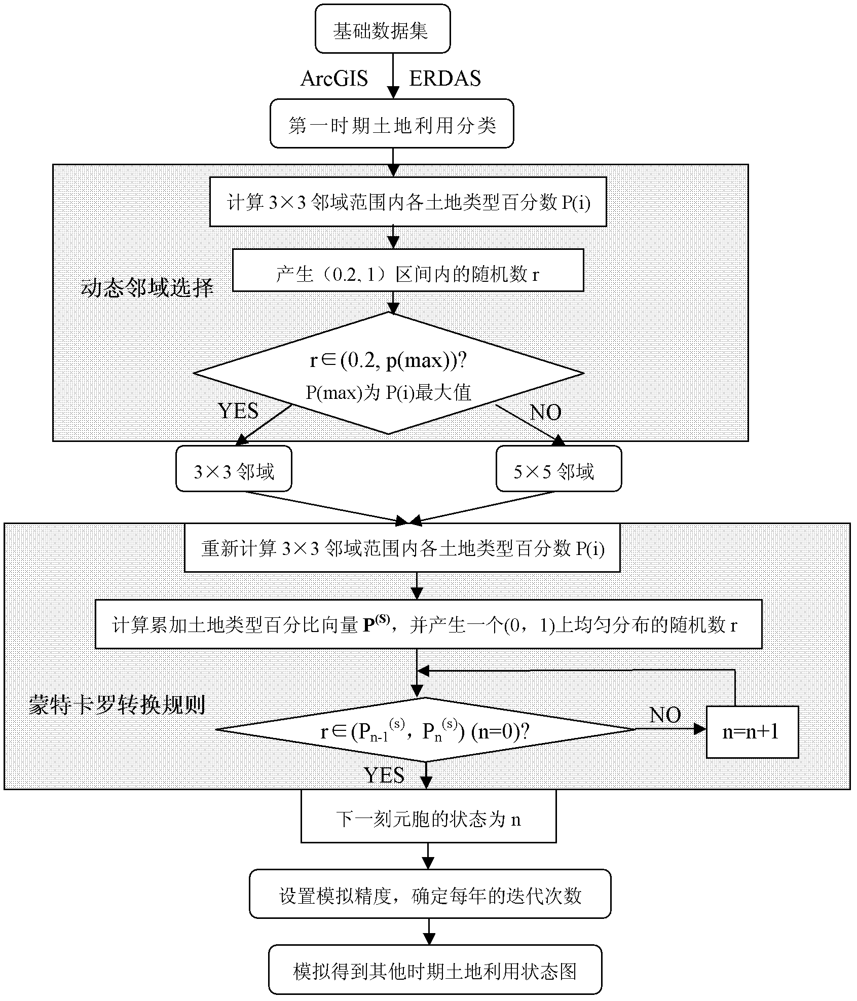
[0036] The flow of urban land use change simulation methods, such as figure 2 shown, including the following steps:

[0037] 1. Data acquisition and preprocessing

[0038] Obtain remote sensing images of two different years in the study area, use ArcGIS, ERDAS and other software to process remote sensing images such as registration, cropping, geometric correction, and finally perform image interpretation and classification. In the present invention, land use types are divided into: water area ( Rivers, lakes), unused land, construction land, and green land (farmland, grassland, woodland) to obtain land use classification maps for two periods.

[0039] 2. Cellular automata model based on Monte Carlo method

[0040] Determine the cell size, cell state i (n=1, 2, 3, ..., k. that is one of the k land use types) and iteration time t according to the classification map (image size and resolution) , using the Monte Carlo method to determine the dynamic neighborhood range.
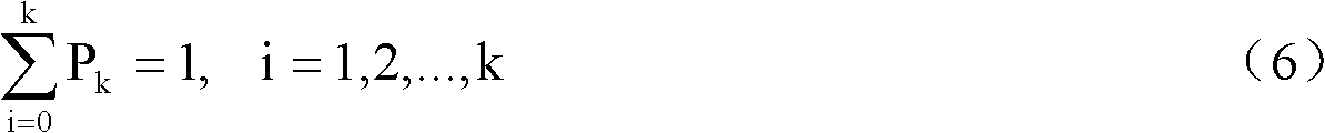
[004...


PUM


Abstract

A method for simulating urban land use change merges an idea of dynamic neighborhood into a cellular automation and a Monte-Carlo model and regulates a range of local neighborhood according to different cell state distribution and by a Monte-Carlo method, so that the problems of spatial-dimension uncertainty and time-dimension randomness of urban land use change are solved, and simulation of the urban land use change is implemented. The method includes: acquiring and preprocessing data; determining cell size, cell state and iteration time according to a classification chart, and using the Monte-Carlo model to determine the range of dynamic neighborhood; establishing a land use change simulation system based on the Monte-Carlo model and the cellular automation model; using the land use change simulation system to simulate and predict by the Monte-Carlo method and the cellular automaton method; and analyzing a land use structure based on simulation results. By the method, the problem of uncertainty occurring in simulation of urban land use change is solved, and simulation effect and precision are improved.

Description

technical field [0001] The invention relates to a method for simulating urban land use change. Mainly use the idea of ​​dynamic neighborhood, combine Monte Carlo method with cellular automata to realize the simulation of urban land use change, so as to provide scientific reference materials and decision-making basis for urban land resource planning management and sustainable development. in the field of earth sciences. Background technique [0002] Land change is a significant manifestation of global environmental change. With the deepening and development of global environmental change research, land change has attracted the attention and attention of many scholars, and has become an important scientific topic in the 21st century. As my country's population, resource and environmental problems become more and more prominent, the study of urban land use change has become an important research content in the sustainable development of cities. Strengthening the simulation of...

Claims


Application Information

Patent Timeline
IPC IPC(8): G06F19/00G06N3/00
Inventor 黄解军李行文吴迎霞詹云军崔巍
Owner WUHAN UNIV OF TECH
Why Eureka
Try Eureka