Beidou satellite monitoring safe driving system based on 3G network

A 3G network and Beidou satellite technology, which is applied in the field of Beidou satellite monitoring safety driving system, can solve problems such as signal blind spots, failure to notify the command department, and failure to provide GPRS services to achieve the effect of improving safety

Inactive Publication Date: 2012-08-29
CHENGDU YIMENG HENGXIN TECH
View PDF6 Cites 45 Cited by
  • Summary
  • Abstract
  • Description
  • Claims
  • Application Information

AI Technical Summary

Problems solved by technology

But because GPS is a passive receiving system, that is, the GPS terminal can know its own location only when it is in use, and cannot notify the command department. The problem brought about like this is that only the driver of the vehicle can accurately grasp the location information of the vehicle, and as a vehicle management The department has no way of knowing the exact location of the vehicle
[0008] At present, the commonly used vehicle data transmission method is mostly GPRS wireless data transmission. Since GPRS uses packet switching technology, and packet switching is not a real-time system, the delay is not fixed, resulting in a large delay in the transmission of information from the vehicle to the ground, and Since GPRS is a service developed on the basis of GSM, that is to say, the use of GPRS depends on the GSM network, and the GSM network has not yet achieved complete coverage in some remote areas or mountainous areas, even if it can be covered. In most areas, GSM signals are greatly affected by the environment, resulting in unstable signals or the formation of signal blind spots, making it impossible to provide GPRS services

Method used


Image

  • Beidou satellite monitoring safe driving system based on 3G network
  • Beidou satellite monitoring safe driving system based on 3G network
  • Beidou satellite monitoring safe driving system based on 3G network

Examples


Embodiment Construction

[0030] The technical solution of the present invention will be further described in detail below in conjunction with the accompanying drawings, but the protection scope of the present invention is not limited to the following description.

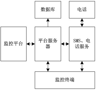
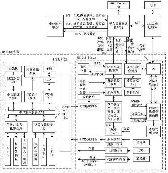
[0031] like figure 1 As shown, the Beidou satellite monitoring and safe driving system based on 3G network includes a platform server located in the monitoring center and one or more monitoring terminals installed on the vehicle side. The monitoring terminal is connected to the platform server through the network communication system. The network The communication system includes 3G network communication system and telecommunication communication system.

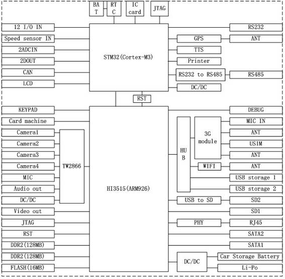
[0032] like figure 2 , image 3 As shown, the monitoring terminal is composed of a casing and a core circuit located in the casing; the core circuit includes a video decoder, a multi-port transponder, a USB to SD converter, GPS, a TTS voice broadcast unit, a micro printing unit, FLASH, ...


PUM


Abstract

The invention discloses a Beidou satellite monitoring safe driving system based on a 3G (third generation) network. The Beidou satellite monitoring safe driving system comprises a platform server positioned in a monitoring center and a monitoring terminal at a vehicle end, wherein the monitoring terminal is connected with the platform server through a network communication system; a monitoring platform, a database, SMS (short message service) and telephone service are operated on the platform server; and the monitoring terminal comprises a housing and a mechanism circuit arranged in the housing. According to the Beidou satellite monitoring safe driving system disclosed by the invention, under the concept of an inter-vehicle network, three major functions, namely positioning by a Beidou vehicle-mounted satellite, 3G wireless video monitoring and vehicle driving recording are firstly integrated, double-CPU (central processing unit) real-time processing, a DSP (digital signal processing) algorithm, an optimization transceiving queue scheduling algorithm, a double-code stream, a special file system, identity comparison identification and other technologies are integrated, video signals collected by a video camera are compressed, encoded and then converted to a compressed code stream, and real-time transmission is realized through the 3G network.

Description

technical field [0001] The invention relates to a 3G network-based Beidou satellite monitoring safety driving system. Background technique [0002] With the rapid development of the transportation industry, some networked, intelligent, and modular advanced products have begun to be applied in vehicles. With the gradual increase of vehicles, how to realize real-time remote monitoring of vehicles in a vast geographical environment, How to reasonably and efficiently strengthen operation scheduling, how to accurately grasp the specific location of each vehicle and a series of problems have become problems that need to be solved urgently. [0003] The Beidou satellite navigation system is a satellite navigation system independently developed by my country. The Beidou satellite navigation system mainly has the following three functions: [0004] One is fast positioning: Beidou navigation system can provide all-weather, high-precision, fast and real-time positioning services for u...

Claims


Application Information

Patent Timeline
Patent Type & Authority Applications(China)
IPC IPC(8): G08G1/127G08G1/00
Inventor 王春波
Owner CHENGDU YIMENG HENGXIN TECH
Why Eureka
Try Eureka