Data fusion system and method of differential GPS (Global Position System) and inertial navigation in intelligent vehicle

An inertial navigation system and data fusion technology, applied in the field of automobile control, to achieve the effect of ensuring reasonable operation and safety

Inactive Publication Date: 2013-07-17
BEIJING UNIV OF TECH
View PDF3 Cites 49 Cited by
  • Summary
  • Abstract
  • Description
  • Claims
  • Application Information

AI Technical Summary

Problems solved by technology

[0007] The present invention mainly aims at the navigation and positioning of intelligent vehicles and the map display of vehicle operation, etc., and proposes a system and method for fusion of differential GPS and inertial navigation data in intelligent vehicles, which

Method used


Image

  • Data fusion system and method of differential GPS (Global Position System) and inertial navigation in intelligent vehicle
  • Data fusion system and method of differential GPS (Global Position System) and inertial navigation in intelligent vehicle
  • Data fusion system and method of differential GPS (Global Position System) and inertial navigation in intelligent vehicle

Examples


Embodiment Construction

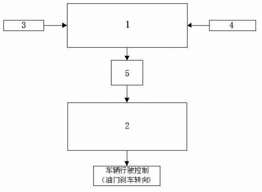
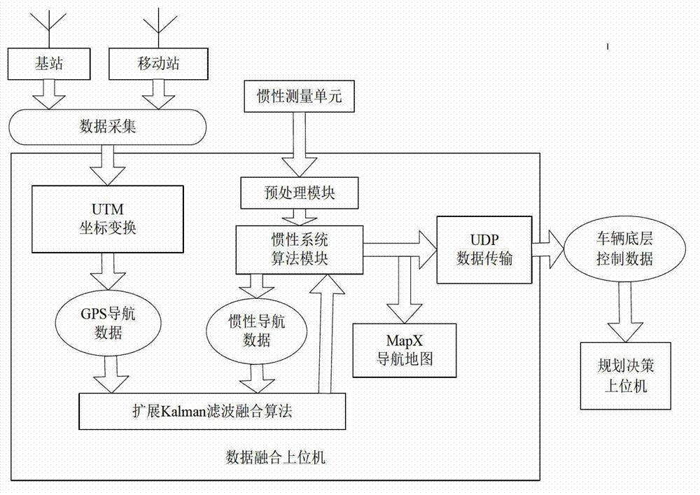
[0030] Such as Figure 1-5 As shown, the system and method for the fusion of differential GPS and inertial navigation data in a smart vehicle of the present invention are composed of upper computers 1, 2, a differential GPS3, and an inertial navigation system composed of two notebook computers equipped with VS2008 programs. 4 and a network router 5.

[0031] The differential GPS3 obtains the GPS data packet corrected by the base station station through the space satellite signal and transmits it to the data fusion host computer 1 through the serial port transmission method; the inertial navigation system 4 collects the driving status information of the intelligent vehicle and transmits it to the data fusion host computer 1 through the serial port; the data fusion The upper computer 1 extracts the information of speed, course and position in the GPS data packet according to the NEMA-0183 protocol and performs coordinate transformation to the earth coordinate system, and simulta...


PUM


Abstract

The invention relates to a data fusion system and method of a differential GPS and an inertial navigation in an intelligent vehicle. The data fusion method of the differential GPS and the inertial navigation in the intelligent vehicle includes utilizing the differential GPS arranged at the top of the vehicle to obtain information provided by a space satellite and utilizing an upper computer which is to perform data fusion to extract GPS data according to the NEMA-0183 protocol to obtain information such as heading, speed and position; utilizing an inertial navigation system arranged in the middle of the inside of the vehicle body to collect data of a heading changing rate and x-axis and y-axis accelerations during vehicle operating, and transmitting the data to the upper computer which is to perform data fusion to obtain a heading angle and the speed and the displacement of the x-axis and the y-axis; and through algorithm integration, finally obtaining accurate navigational positioning information and utilizing the inertial system to provide RI (Related Information) under the condition that the GPS signals are lost. Besides, the method further includes displaying the navigational positioning data in a map and transmitting the packed data to a planning decision-making upper computer through an LAN (Local Area Network) created through a router, and controlling the intelligent vehicle according to analyzed information and actual travelling conditions.

Description

technical field [0001] The invention relates to a system and method for fusion of differential GPS and inertial navigation data in an intelligent vehicle, belonging to the field of vehicle control. Background technique [0002] Intelligent vehicles, also known as unmanned driving, are an important application of outdoor wheeled mobile robots in the field of transportation. It uses on-board sensors (lidar, ultrasonic sensor, inertial system, vision, GPS, odometer, magnetic compass, etc.) to perceive the surrounding environment of the vehicle and obtain its own position and attitude. Intelligent vehicles have a high degree of self-planning, self-organization and self-adaptive capabilities. Without human intervention, they can control the steering and speed of the vehicle based on the road, vehicle pose and obstacle information obtained through perception, so that the vehicle can Drive safely and reliably on the road and complete the intended tasks. [0003] The application o...

Claims


Application Information

Patent Timeline
IPC IPC(8): G05D27/02G01S19/47G01C21/34
Inventor 段建民王凡
Owner BEIJING UNIV OF TECH
Why Eureka
Try Eureka