
General aviation flight navigation system based on Beidou satellite navigation

A Beidou satellite and navigation system technology, which is applied in the field of general aviation flight navigation system and aviation flight navigation system, can solve the problems of lack of portable handheld navigation equipment and short manufacturing cycle, and achieve the effect of improving recognition speed and ensuring flight safety

Inactive Publication Date: 2016-02-10
天津天航创力科技有限公司
View PDF8 Cites 0 Cited by
  • Summary
  • Abstract
  • Description
  • Claims
  • Application Information

AI Technical Summary

Problems solved by technology

[0009] However, although the aviation flight safety guarantee equipment in the past has made great progress in technology, it still lacks portable handheld navigation equipment with two-dimensional and three-dimensional visual positioning and navigation functions. The portable handheld navigation equipment is simple in structure and relatively cheap in cost. The cycle is short, the use is quick, and the scope of application is wide. It provides an option for speeding up the deployment of ground navigation stations in the western region. Through the unique system architecture, constellation layout and communication functions of the "Beidou" (BDS) system, it can cover all routes and airspace

Method used


Image

  • General aviation flight navigation system based on Beidou satellite navigation
  • General aviation flight navigation system based on Beidou satellite navigation
  • General aviation flight navigation system based on Beidou satellite navigation

Examples


Embodiment Construction

[0041] In order to understand the present invention more clearly, describe the present invention in detail in conjunction with accompanying drawing and embodiment:

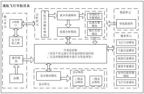
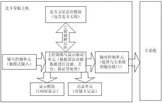
[0042] Such as Figure 1 to Figure 3 As shown, the Beidou navigation host includes a Beidou satellite positioning module, a main controller, a display drive unit, a display module, a recording unit, an input control unit, and an output control unit;

[0043] The Beidou satellite positioning module is composed of a radio frequency chip, a baseband chip and a peripheral circuit, and is used for receiving

[0044] Navigation data from a satellite positioning system that reflects your current location.

[0045] The main controller is composed of a single-chip microcomputer, an instruction register, an instruction decoder, a timing generator, and a programmable logic controller, and is used for filtering, differencing, and verifying the source data, and uniformly deploying each unit module.

[0046]The display drivin...


PUM


Abstract

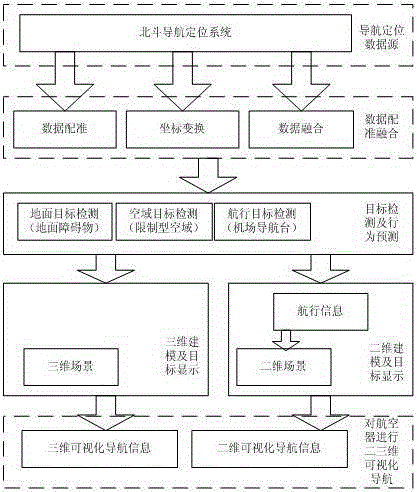
The invention relates to a navigation flight navigating system based on BeiDou satellite navigation. The navigation flight navigating system comprises a BeiDou navigation mainframe and a tablet personal computer. The BeiDou navigation mainframe comprises a BeiDou satellite positioning module, a main controller, a display driving unit, a display module, a recording unit, an input control unit and an output control unit. The method includes the steps of firstly, obtaining navigation positioning data through the BeiDou navigation mainframe; secondly, conducting data registering and fusing; thirdly, detecting a target and forecasting behaviors; fourthly, conducting three-dimensional modeling and displaying the target; fifthly, conducting the two-dimensional modeling and display the target; sixthly, conducting three-dimensional visual navigation on an aircraft; seventhly, conducting two-dimensional visual navigation on the aircraft. The navigation flight navigating system has the advantages that the functions including the positioning function, the navigation function and the like of the GPS are achieved, and the communication function is further achieved; the shortest time of primary positioning of the GPS is more than one minute, but the aircraft can be positioned within several seconds through BeiDou, and therefore the recognition speed is effectively increased; BeiDou is a positioning and navigating system which is independently developed by China, and therefore the navigation flight navigating system is more reliable when applied.

Description

technical field [0001] The invention relates to the field of navigation, in particular to a general navigation flight navigation system based on Beidou satellite navigation, in particular to a navigation system applied to aviation flight. Background technique [0002] As one of the core technologies in the air transportation system, navigation technology is crucial to the safe production and stable development of the industry, and it is also an important manifestation of the current development. [0003] Navigation is a technology that provides continuous, safe and reliable service while a carrier is underway. Especially in aviation technology, because the aircraft must maintain a relatively fast speed in the air, the time to stay in the air is limited, and the consequences of accidents are serious, which puts forward higher requirements for navigation. At the same time, the limited volume of aircraft limits the selection of navigation equipment. [0004] For air transporta...

Claims


Application Information

Patent Timeline
Patent Type & Authority Patents(China)
IPC IPC(8): G08G5/00
Inventor 徐肖豪王超李楠刘百庚王文亮杨棹王浦玲
Owner 天津天航创力科技有限公司
Learn More