Super-mapping machine

A super, remote measurement system technology, applied in the field of measurement, can solve the problems of not having the conditions for erecting instruments, large volume, loose system structure, etc.

Active Publication Date: 2014-06-04
许凯华
View PDF9 Cites 17 Cited by
  • Summary
  • Abstract
  • Description
  • Claims
  • Application Information

AI Technical Summary

Problems solved by technology

Traditional equipment relies on manual operation, and the human errors and the errors introduced into the geodetic coordinates in segments are large and there is no effective error correction method
The efficiency of traditional equipment is very low, and obtaining a low-precision three-dimensional geodetic coordinate of the object space often requires a team of professional and technical personnel to work for a long time
It consumes a lot of manpower and time, and the actual work cost is high
[0013] (2) GPS locator: The instrument must be erected on the measured target for observation. This first requires that the measured target has the conditions for erecting the instrument. The target points that need to be measured often do not have the conditions to set up the instrument
[0014] (3) Total station: It can only measure angles and distances in a custom coordinate system; it completely relies on manual operation, the human error is large and there is no effective error correction method; when measuring the three-dimensional coordinates of the object, it is necessary to have more than two Known control points; To determine the direction of true north, you must purchase the data of the local GPS control netw

Method used


Image

  • Super-mapping machine
  • Super-mapping machine
  • Super-mapping machine

Examples


example 1

[0360] Example 1. Dynamic target image recognition and automatic tracking:

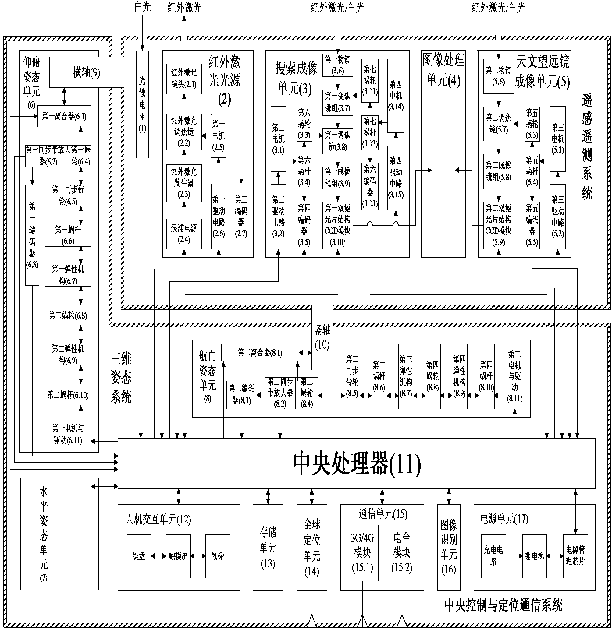
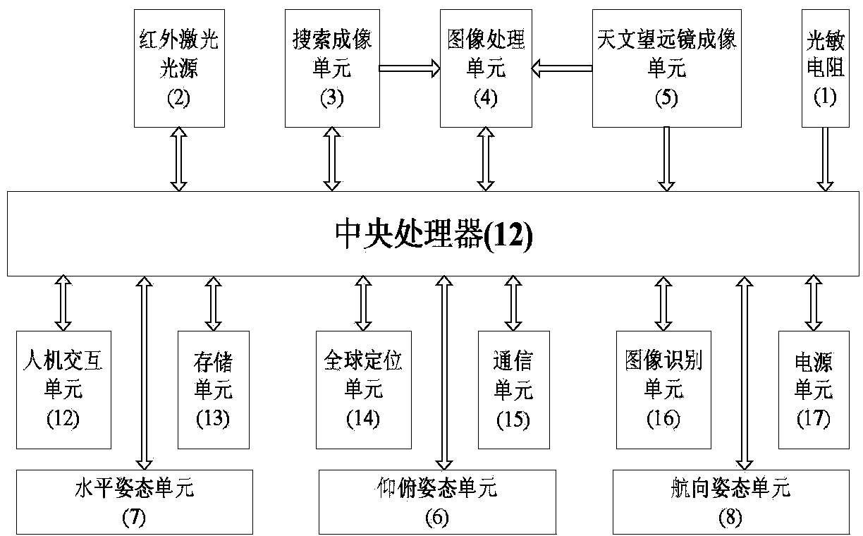
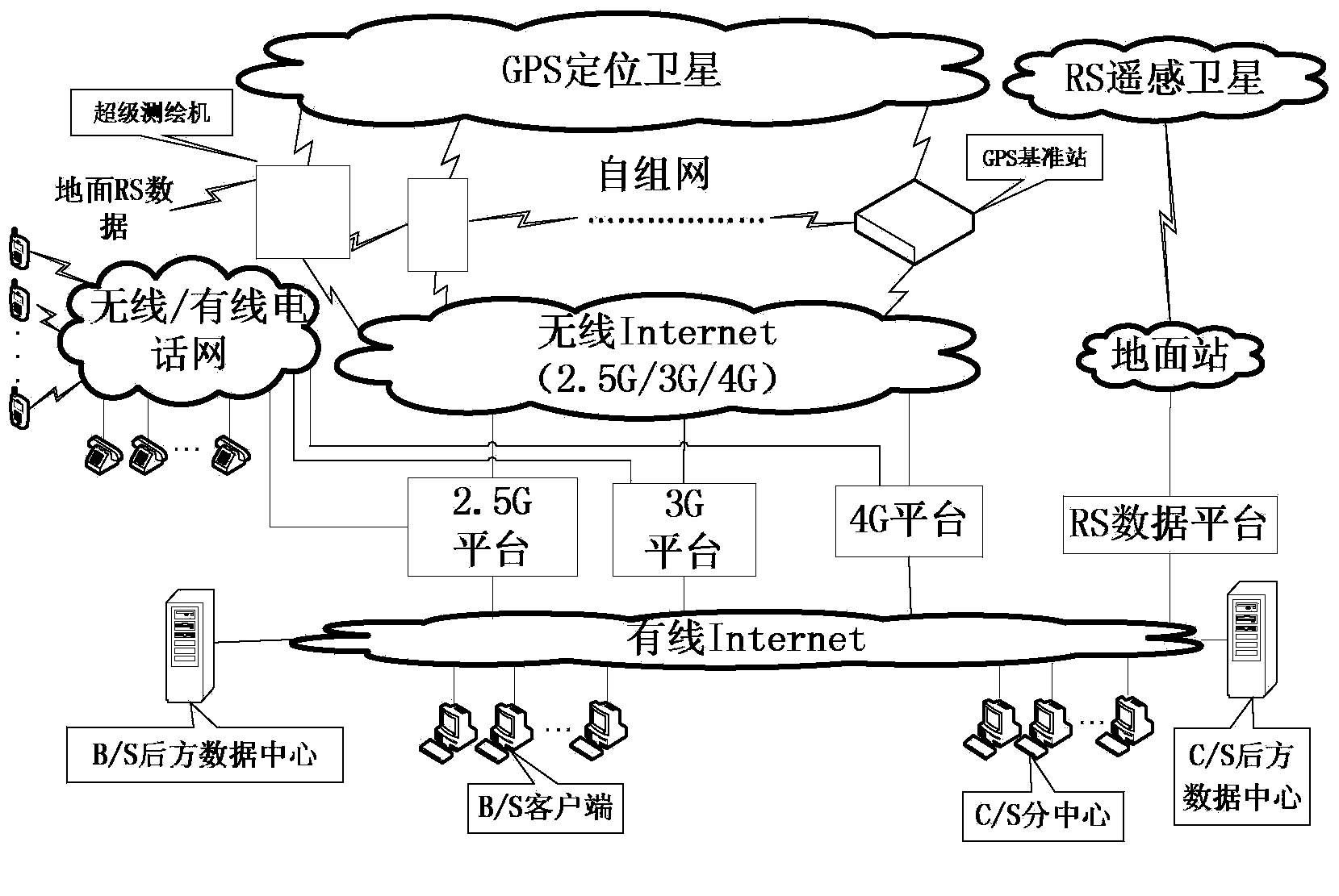
[0361] The super surveying machine automatically retrieves the image library in its storage unit 3, compares the obtained target image with it and recognizes it. If the recognition is successful and the need is confirmed, the tracking program will be started by itself, and it will enter fully automatic target tracking. When it cannot be identified or the calculation load is too large, the super mapping machine will automatically link to the rear data center (see image 3 .The communication schematic diagram of the present invention) starts the cloud computing / cloud library function, and the rear data center completes the calculation in real time and then downloads the image recognition data, and the super surveying machine confirms the need and enters (or exits) the automatic target tracking accordingly.

example 2

[0362] Example 2. Over-the-horizon collimator: replace the virtual station with a global positioning device, then a global positioning device can be used without observation, without direct vision, without weather, air quality, obstacles, distance between itself and the target The 3D attitude data needed to automatically aim at the target at the current position can be acquired continuously at high speed under the limitation of various factors such as distance and own moving speed.

example 3

[0363] Example 3. Over-the-horizon range finder: replace the virtual station with a global positioning device, and a global positioning device can be used without any distance measurement equipment, without observation, without direct vision, without being affected by weather and air quality , Obstacles, distance between itself and the target, self-moving speed, ranging frequency and other factors are limited, and the distance data between itself and the target can be obtained continuously at high speed.


PUM


Abstract

The invention discloses a super-mapping machine which comprises a remote sensing and telemetering system, a three-dimensional attitude system and a central control and positioning communication system, wherein the remote sensing and telemetering system comprises an infrared laser light source (2), a search imaging unit (3), an image processing unit (4), an astronomical telescope imaging unit (5) and a photoresistor (1); the three-dimensional attitude system comprises a pitching pose unit (6), a horizontal axis (9), a horizontal attitude unit (7), a heading attitude unit (8) and a vertical axis (10); the central control and positioning communication system comprises a central processing unit (11), a man-machine interaction unit (12), a storage unit (13), a global positioning unit (14), a communication unit (15), an image recognition unit (16) and a power supply unit (17). The invention provides a field portable machine system which can acquire high-precision three-dimensional images in a geodetic coordinate system under the range finder-free conditions.

Description

technical field [0001] The invention belongs to the technical field of surveying, in particular to a super surveying and mapping machine. Background technique [0002] There are tens of thousands of applications in the geographic information industry, all stemming from four core requirements: [0003] 1) Obtain the three-dimensional geodetic coordinates of the target; [0004] 2) Obtain the topographic and feature map under the three-dimensional geodetic coordinates; [0005] 3) Obtain the 3D image of the object space under the 3D geodetic coordinates; [0006] 4) Obtain the 3D navigation map based on the 3D image in the geodetic coordinate system. [0007] The current technical status is that multiple groups of personnel use a wide variety of multiple groups of instruments and equipment to obtain the above-mentioned core requirements segmented in different ways to form various applications. The existing limitations are low efficiency, time-consuming service, high cost, ...

Claims


Application Information

Patent Timeline
IPC IPC(8): G01C15/00
CPCG01C11/02G01C15/00
Inventor 许凯华
Owner 许凯华
Why Eureka
Try Eureka