Ground settlement risk grade evaluation method based on cloud model and data field

A land subsidence and risk level technology, applied in the field of level assessment, can solve problems such as information redundancy, lack of data processing methods, unreliable collection and processing of monitoring points, etc.

Inactive Publication Date: 2014-11-05
CAPITAL NORMAL UNIVERSITY
View PDF2 Cites 28 Cited by
  • Summary
  • Abstract
  • Description
  • Claims
  • Application Information

AI Technical Summary

Problems solved by technology

But it also has many limitations: From the perspective of error propagation, the accuracy of DInSAR applied to regional deformation measurement is affected by several uncertain factors, including orbital data errors, terrain data errors, phase noise caused by interference decorrelation, phase Unwrapping error and atmospheric delay error, etc.
However, conventional PSInSAR technology has too many parameters to deal with, and the estimation of the atmosphere is not accurate enough in large are...

Method used


Image

  • Ground settlement risk grade evaluation method based on cloud model and data field
  • Ground settlement risk grade evaluation method based on cloud model and data field
  • Ground settlement risk grade evaluation method based on cloud model and data field

Examples


Embodiment 1

[0058] A method for assessing the risk level of land subsidence based on a cloud model and a data field, the method comprising the following steps:

[0059] 1) Obtain the deformation phase value of the time series, and obtain the corresponding PS point settlement data;

[0060] 2) Using the reverse cloud generator cloud model algorithm to obtain three cloud digital features of the PS point settlement data, the three cloud digital features are the expected E x , entropy E n and hyperentropy H e ; The three cloud digital eigenvalues ​​represent the ground subsidence line-of-sight displacement change and the PSInSAR monitoring level reflected by the monitoring data, so as to obtain the PS point after optimization; Wherein, expect E x Indicates the expected location of the monitoring point settlement, entropy E n Indicates the degree of dispersion of the settlement of the monitoring point relative to the expected position, the hyperentropy H e Reflect the overall monitoring le...

Embodiment 2

[0066] A method for assessing the risk level of land subsidence based on a cloud model and a data field, the method comprising the following steps:

[0067] 1) Obtain the deformation phase value of the time series through the following steps, and obtain the corresponding PS point settlement data;

[0068] 3.1 In the N SAR dataset images, according to the image acquisition time period, select a radar image with a relatively uniform imaging time from other images as the main image, and use other SAR images as auxiliary images for interference processing to obtain M interferograms ;

[0069] 3.2 Perform radiometric calibration on N SAR dataset images;

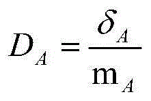
[0070] 3.3 In the calibrated SAR data set images, the PS points are screened by analyzing the amplitude characteristics of the pixels; the amplitude characteristics are determined by the amplitude dispersion index D A Indicates that the formula is

[0071] D A = ...

Embodiment 3

[0091] A method for assessing the risk level of land subsidence based on a cloud model and a data field, the method comprising the following steps:

[0092] 1) Obtain the deformation phase value of the time series through the following steps, and obtain the corresponding PS point settlement data;

[0093] 3.1 In the N SAR dataset images, according to the image acquisition time period, select a radar image with a relatively uniform imaging time from other images as the main image, and use other SAR images as auxiliary images for interference processing to obtain M interferograms ;

[0094] 3.2 Perform radiometric calibration on N SAR dataset images;

[0095] 3.3 In the calibrated SAR data set images, the PS points are screened by analyzing the amplitude characteristics of the pixels; the amplitude characteristics are determined by the amplitude dispersion index D A Indicates that the formula is

[0096] D A = ...


PUM


Abstract

The invention provides a ground settlement risk grade evaluation method based on a cloud model and a data field. According to the method, a PS point is optimized through a cloud model algorithm; then, the data field is used for carrying out automatic clustering on the settlement speed, the population density and the economic density; the obtained settlement speed classification grade, the population density lattice grade or the economic density lattice grade are overlapped; and a ground settlement risk grading chart is generated. The evaluation method adopted by the invention considers the uncertainty of ground settlement risks and the relevance among the ground settlement risks; the influence on the ground settlement by factors such as hazard factor risks, hazard-affected body vulnerability and hazard-formative environment is integrated; the evaluation method is more scientific, reliable and accurate; and a reliable basis is provided for the ground settlement risk grading.

Description

technical field [0001] The invention belongs to the field of geological disaster monitoring, in particular to a method for evaluating land subsidence risk levels based on cloud models and data fields. Background technique [0002] Land subsidence is one of the important contents of geological environment work. It is a slow surface deformation process, and the disaster-causing process is slow. Once formed, it is difficult to recover. Its causes are very complex, among which natural geological factors are mainly: self-consolidation and compaction of loose strata or semi-loose strata on the surface; geological tectonics, ups and downs of the crust; climate change, earthquakes, volcanic eruptions; karst subsidence in karst-developed areas, etc. The main factors of human activities are: massive mining of underground resources, including underground fluid resources, solid mineral resources and geothermal resources; large-scale engineering construction, rail transit, urban undergro...

Claims


Application Information

Patent Timeline
IPC IPC(8): G06F19/00
Inventor 宫辉力陈蓓蓓李小娟赵文吉颉晋荣贾煦郭琳段光耀周超凡史珉
Owner CAPITAL NORMAL UNIVERSITY
Why Eureka
Try Eureka