Satellite passive positioning method based on GPS broadcast data

A technology for broadcasting data and positioning methods, applied in the field of passive satellite positioning, can solve the problems of weak autonomy and low positioning accuracy, and achieve the effects of strong on-board autonomy, less resource occupation, and high-precision observation data collection

Active Publication Date: 2015-03-04
SHANGHAI SATELLITE ENG INST
View PDF3 Cites 6 Cited by
  • Summary
  • Abstract
  • Description
  • Claims
  • Application Information

AI Technical Summary

Problems solved by technology

[0006] The traditional positioning process uses the attitude and orbit control system to provide the recursive position and velocity data of the satellite, and the positio...

Method used


Image

  • Satellite passive positioning method based on GPS broadcast data
  • Satellite passive positioning method based on GPS broadcast data
  • Satellite passive positioning method based on GPS broadcast data

Examples


Embodiment Construction

[0058] The present invention will be described in detail below in conjunction with specific embodiments. The following examples will help those skilled in the art to further understand the present invention, but do not limit the present invention in any form. It should be noted that those skilled in the art can make several modifications and improvements without departing from the concept of the present invention. These all belong to the protection scope of the present invention.

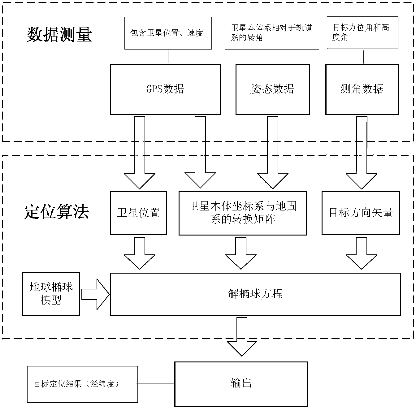
[0059] The on-satellite positioning method proposed by the invention can meet the target positioning accuracy proposed by the user. Judging from the test situation in the satellite development process, this method is reasonable and reliable. With the rapid development of aerospace technology, satellites will play a more important role in information support operations and disaster relief. This method will provide reference and basis for future low-orbit passive electronic reconnaissance satellite ...


PUM


Abstract

The invention provides a satellite passive positioning method based on GPS broadcast data. The method comprises: acquiring measuring data of a satellite; according to the measuring data, calculating a conversion matrix M from an earth-fixed coordinate system to a satellite local system; selecting an earth ellipsoidal model and obtaining corresponding earth geometrical parameters and an earth ellipsoidal surface equation; and according to the conversion matrix M, solving an object position equation, and solving object position coordinates by simultaneously solving the earth ellipsoidal surface equation. The measuring data comprises the GPS broadcast data including a satellite real-time position P<se><-> and a speed V<se><->, object measurement angles beta<x> and beta<y> and attitude angle data, i.e., a pitch angle phi, a yaw angle yaw angle gamma and a roll angle theta, wherein the GPS broadcast data is obtained through a satellite data bus, the beta<x> and the beta<y> are obtained through a load subsystem, and the attitude angle data is obtained through an attitude orbit control subsystem. According to the invention, the high-precision GPS broadcast data is taken as a system input quality, such that the precision of each parameter during a calculation process is ensured, accordingly, the precision of a positioning result is ensured, at the same time, an offline processing process is unnecessary, and the satellite autonomous calculating capability is enhanced.

Description

technical field [0001] The invention relates to the technical field of satellite passive positioning, in particular to an on-board passive positioning method based on GPS broadcast data. Background technique [0002] Outer space is shared by all human beings and has no national boundaries. The use of satellites to locate targets is not restricted by territory, territorial waters, or airspace. Satellite passive positioning is to use satellites to receive radio signals radiated by the target itself to locate the target. It has the characteristics of long distance and good concealment, so it is widely used. Satellite passive positioning technology has always been one of the hot spots in satellite application technology research. [0003] The satellite passive positioning process puts forward higher requirements on the following capabilities of the satellite: [0004] (1) The positioning principle uses the position and attitude information of the satellite itself and the direc...

Claims


Application Information

Patent Timeline
IPC IPC(8): G01S19/42
CPCG01S19/42
Inventor 许哲沈庆丰叶小舟陈占胜黄欣董泽政
Owner SHANGHAI SATELLITE ENG INST
Why Eureka
Try Eureka