Sea ice thickness estimation method based on experimental data of multi-beam altimeter (MABEL)

A technology of multi-beam height and experimental data, applied in the application field of remote sensing geology, can solve problems such as increasing the uncertainty of sea ice thickness estimation, and achieve the effects of improving data processing efficiency, high execution efficiency and efficiency improvement.

Inactive Publication Date: 2015-04-22
NANJING UNIV
View PDF7 Cites 6 Cited by
  • Summary
  • Abstract
  • Description
  • Claims
  • Application Information

AI Technical Summary

Problems solved by technology

However, due to the penetrability of the radar altimeter itself, radar waves penetrate the snow to reach the sea ice and are likely to be reflected at the snow-ice interface rather than from the snow surface
Increased uncertainty in sea ice thickness estimates due to presence of surface snow

Method used


Image

  • Sea ice thickness estimation method based on experimental data of multi-beam altimeter (MABEL)
  • Sea ice thickness estimation method based on experimental data of multi-beam altimeter (MABEL)
  • Sea ice thickness estimation method based on experimental data of multi-beam altimeter (MABEL)

Examples


Embodiment Construction

[0044] The present invention will be described in detail below according to the accompanying drawings, so as to make the technical route and operation steps of the present invention clearer.

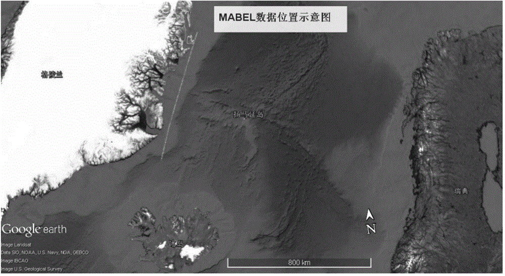
[0045] The data used in the example of the present invention is the MABEL data of the US NASA Goddard Space Flight Center (Goddard Space Flight Center), the data number: mabel_l2_20120410t160100_008_1, the data location is the Greenland sea area (the east side of Greenland), and the acquisition time is April 10, 2012 day. as shown in the picture figure 2 As shown, the green line in the figure indicates the flight aerial photography

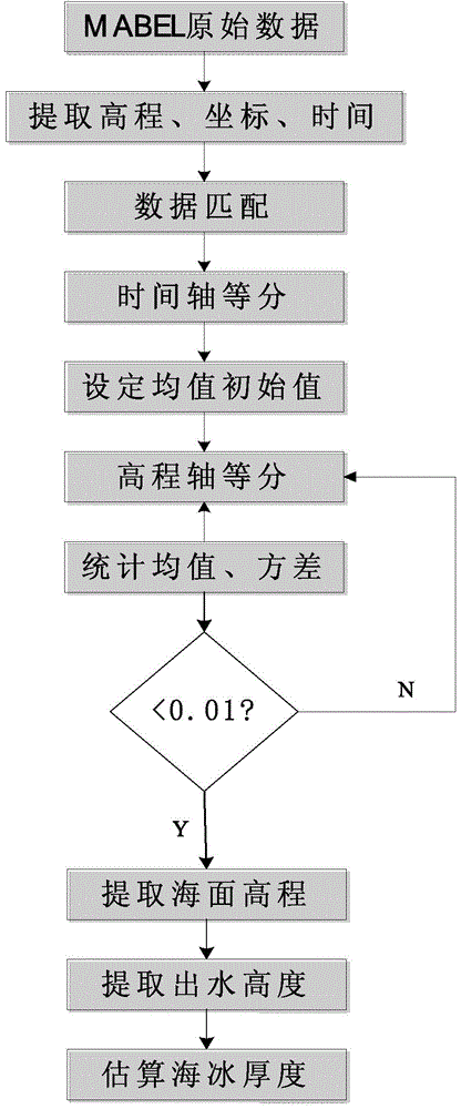
[0046] figure 1 It is the flow chart of the sea ice thickness estimation method based on the multi-beam altimeter experimental data in this embodiment, and the specific steps are as follows:

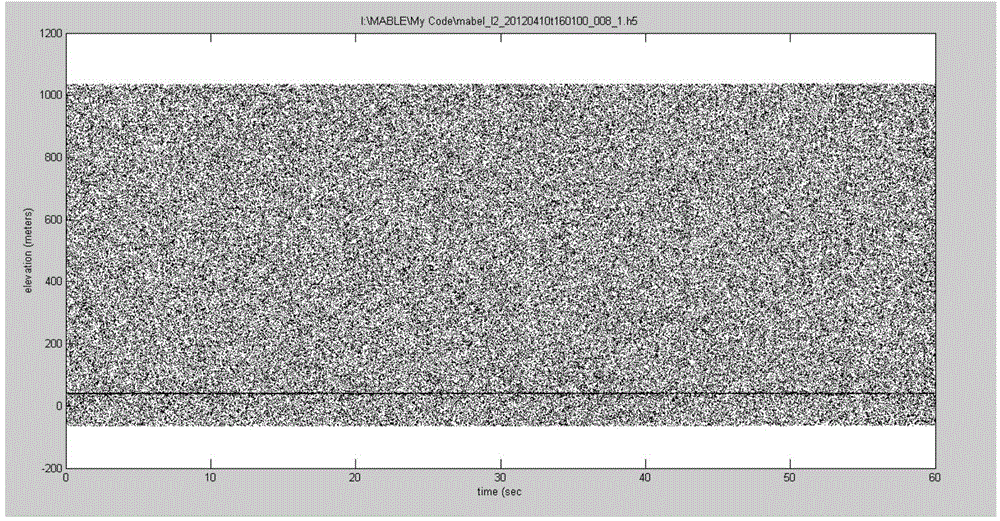
[0047] The first step is to read the raw data of MABEL, extract the time data, elevation data and latitude and longitude data of reflected photons, and perform mat...


PUM


Abstract

The invention relates to a sea ice thickness estimation method based on experimental data of a multi-beam altimeter (MABEL). The method comprises the following steps: preprocessing MABEL data, extracting altitude and coordinate information for matching, and removing an atmospheric effect; then performing time shaft equal division and altitude division, constructing a two-dimensional grid, and extracting an interval with the largest number of photons; performing treatment of calculating mean variance and the like to further eliminate invalid photons to acquire a sea surface contour line; and finally, estimating the sea ice thickness by combining a hydrostatics equilibrium formula according to the sea ice height out of water. Compared with the traditional method, the MABEL data is introduced into the method provided by the invention to estimate the sea ice thickness, so that the precision is higher.

Description

technical field [0001] The invention relates to a sea ice thickness estimation method based on multiple beam altimeter experimental data (Multiple Altimeter Beam Experimental Lidar, MABEL), which belongs to the technical field of remote sensing geoscience applications. Background technique [0002] Sea ice has always been considered as one of the key variables of global climate change. It is an early warning platform for global atmospheric and oceanic circulation variations. Exchange process and rate. [0003] At present, the sea ice thickness measurement methods at home and abroad can be roughly divided into two categories: one is the direct measurement method, and the other is the remote sensing measurement method. Direct measurement is to use thickness measurement tools and instruments to directly measure sea ice on the spot, including: underwater sonar method, ice drilling to penetrate sea ice thickness measurement, etc. However, due to the limitation of environmental c...

Claims


Application Information

Patent Timeline
Patent Type & Authority Applications(China)
IPC IPC(8): G01B11/06
Inventor 柯长青邵珠德夏深圳贺骊印
Owner NANJING UNIV
Why Eureka
Try Eureka