Three-dimensional space fine measuring system for underground cavities

A measurement system and three-dimensional space technology, which is used in measurement devices, mapping and navigation, instruments, etc., can solve the problems of large cumulative error, low precision, and increased man-hours, so as to achieve high measurement point cloud density and save measurement time and space. Evenly distributed effect

Active Publication Date: 2015-07-22
TSINGHUA UNIV
View PDF10 Cites 18 Cited by
  • Summary
  • Abstract
  • Description
  • Claims
  • Application Information

AI Technical Summary

Problems solved by technology

For the measurement of linear structures, there is already a vehicle-mounted mobile measurement system on the market. When the vehicle is moving at high speed, it uses the inertial navigation module or GPS module to perform three-dimensional positioning of the position, and at the same time uses laser scanners and photography technology to perform real-time three-dimensional positioning. Information acquisition and storage, the collection speed is fast, the collection information is rich, and it is easy to use. However, the positioning accuracy of GPS depends heavily on the real-time and visibility of GPS signals. For underground projects, GPS signals are often missing, and the inertial navigation module is increases, the cumulative error will become larger and larger
Moreover, for underground engineering, other positioning methods such as positioning based on RFID radio frequency signals, positioning based on Wi-Fi network signals and other technologies need to lay out base stations and lines, and the accuracy is not high, and they are not suitable for fine measurement in three-dimensional space.
[0005] Moreover, most of the existing measurement methods are separated from the field and the interior. First, the field data is collected, and then returned to the room for data processing and analysis, which greatly increases the man-hours. Moreover, measurement errors or insufficiencies are found during data processing. When the test is performed, it is impossible to retest or make up the test, which brings difficulties to the follow-up analysis and effective use of the data

Method used


Image

  • Three-dimensional space fine measuring system for underground cavities
  • Three-dimensional space fine measuring system for underground cavities
  • Three-dimensional space fine measuring system for underground cavities

Examples


Embodiment Construction

[0018] The present invention provides a three-dimensional fine measurement system for underground caverns; the following will be further described in detail in conjunction with the accompanying drawings and implementation methods:

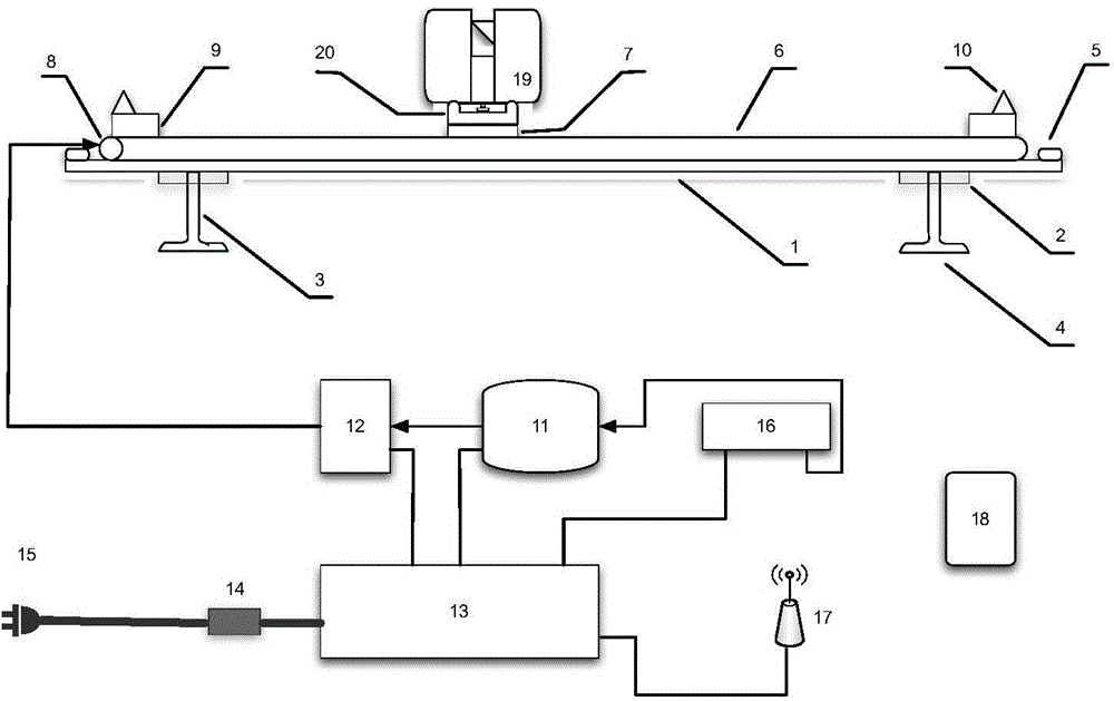
[0019] figure 1 It is a schematic diagram of the cross-section fine measurement system. The three-dimensional space fine measurement system in the figure includes guide rail support device, laser scanning sensor, guide rail motion control device, power supply device, main control computer, wireless access point and tablet computer; wherein, laser scanning sensor 19, guide rail motion control device, power supply device , a main control computer 16, a wireless access point 17, a tablet computer 18 and the like. Among them, the guide rail bracket device is made of aluminum alloy profiles, and two vertical supports 3 are fixed under the horizontal beam 2, and each vertical support 3 is fixed with the feet 4 to form; a horizontal main beam 1 is placed...


PUM


Abstract

The invention belongs to the technical field of underground space measurement, and discloses a three-dimensional space fine measuring system for underground cavities. The measuring system comprises a guide rail support device, a laser scanning sensor, a guide rail motion controller, a power supply device, a main control computer, a wireless access point and a tablet personal computer. A horizontal girder is arranged on the guide rail support device, a limit switch, a stepping motor and a positioning target are fixed on the horizontal girder, and the laser scanning sensor is fixed to a laser scanning sensor adapter and a slider. The guide rail motion controller provides accurate positioning for the measuring system. The laser scanning sensor performs fine scanning on cress section outline of a three-dimensional space according to flight principles and returns distance, angle and strength information of the cross section outline in real time. The main control computer controls the guide rail motion controller and the laser scanning sensor to complete three-dimensional space fine measurement based on cross section measurement. The three-dimensional space fine measuring system has the advantages that active non-contact measurement is adopted, measurement point cloud density is large, measurement point space distribution is uniform, internal and external operations can be performed simultaneously, measurement time is saved, and positioning accuracy can reach 1-3mm.

Description

technical field [0001] The invention belongs to the technical field of underground space measurement, in particular to a three-dimensional fine measurement system for underground caverns. Background technique [0002] For the three-dimensional space measurement of underground caverns, there are many methods at home and abroad, such as acoustic wave measurement, close-range photogrammetry, laser total station, laser scanner three-dimensional measurement and other methods. [0003] For most underground projects, the spatial arrangement of caverns is complex, the size of a single cavern is large, and the shape of the cavern structure is complex. Especially for unlined underground caverns, the rock surface is uneven, and three-dimensional spatial fine measurement is urgently needed. However, the current method will greatly increase the labor intensity of the field and the office if fine measurement is carried out. Although the current 3D scanning equipment can quickly measure a...

Claims


Application Information

Patent Timeline
IPC IPC(8): G01B11/00G01C7/06
Inventor 段云岭吕小宁冯金铭乔楠
Owner TSINGHUA UNIV
Why Eureka
Try Eureka