
Multipoint positioning monitoring system and multipoint positioning monitoring method in airport non-line-of-sight (NLOS) channel environment

A channel environment, multi-point positioning technology, applied in positioning, radio wave measurement systems, measurement devices, etc., can solve problems that are not suitable for multi-point positioning real-time processing requirements application systems, stay in the theoretical research stage, etc.

Active Publication Date: 2015-08-12
THE SECOND RES INST OF CIVIL AVIATION ADMINISTRATION OF CHINA
View PDF9 Cites 16 Cited by
  • Summary
  • Abstract
  • Description
  • Claims
  • Application Information

AI Technical Summary

Problems solved by technology

However, in the actual airport environment, the NLOS channel model changes in real time with the movement of the active target and the surrounding traffic situation. Therefore, this system architecture is still mainly in the theoretical research stage, and it is not suitable for multi-point positioning, which requires relatively high real-time processing. operating system

Method used


Image

  • Multipoint positioning monitoring system and multipoint positioning monitoring method in airport non-line-of-sight (NLOS) channel environment
  • Multipoint positioning monitoring system and multipoint positioning monitoring method in airport non-line-of-sight (NLOS) channel environment
  • Multipoint positioning monitoring system and multipoint positioning monitoring method in airport non-line-of-sight (NLOS) channel environment

Examples


Embodiment 1

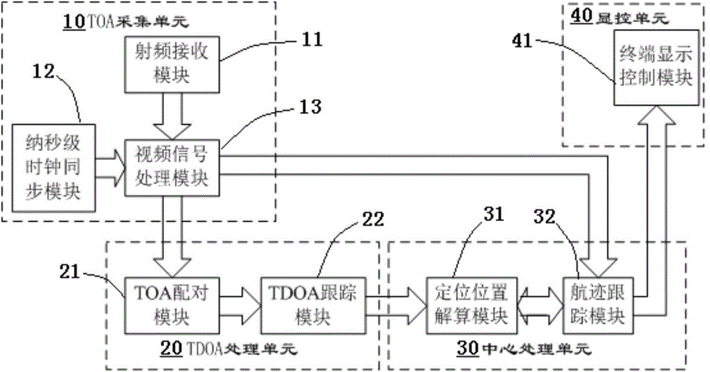
[0063] like figure 1 As shown, this embodiment discloses a multilateration monitoring system in a non-line-of-sight channel environment, including:

[0064] TOA collection unit 10: collect the time stamp of the signal arriving at each ground receiving station and the status information of the active target, and generate TOA information, target identification, and elevation information;

[0065] TDOA processing unit 20: complete TOA pairing, calculation of original TDOA between two stations and TDOA filtering and tracking processing according to the TOA information of the TOA acquisition unit, and generate corrected TDOA information;

[0066] Central processing unit 30: read the decoding information of the TOA acquisition unit to complete the identification of the active target and record its elevation information, and generate positioning position information according to the corrected TDOA information and elevation information, and then read the positioning position of the ta...

Embodiment 2

[0069] Embodiment 2. In this embodiment, the four functional units of the multilateration monitoring system under the non-line-of-sight channel environment are further described in detail.

[0070] The TOA acquisition unit is mainly responsible for the acquisition of the time stamp (TOA) and target identification information of the 1090MHz wireless radio frequency signals emitted by aircraft, vehicles and other moving targets when they arrive at each ground receiving station, including radio frequency receiving modules, nanosecond clock synchronization modules and video signal processing module. The radio frequency receiving module is mainly composed of a 1090MHz narrowband receiving antenna feeder, a superheterodyne receiver and a 10MHz stable crystal clock card, which is responsible for the demodulation and processing of 1090MHz signals; the nanosecond clock synchronization module mainly includes a dedicated active GPS timing sub-module, 20MHz The stable crystal clock card i...

Embodiment 3

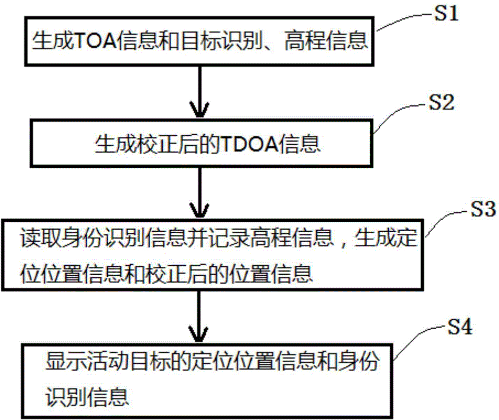
[0088] refer to figure 2 , this embodiment discloses a multilateration monitoring system in a non-line-of-sight channel environment, including:

[0089] TOA collection unit 10: collect the time stamp of the signal arriving at each ground receiving station and the status information of the active target, and generate TOA information, target identification, and elevation information;

[0090] TDOA processing unit 20: complete TOA pairing 21, calculation of original TDOA between two stations and filtering and tracking processing 22 of TDOA according to the TOA information of TOA acquisition unit 10, and generate corrected TDOA information;

[0091] Central processing unit 30: read the decoded information of the TOA acquisition sheet 10 to complete the identification of the active target and record its elevation information, and generate positioning position information according to the corrected TDOA information and elevation information, and then read the positioning position o...


PUM


Abstract

The invention discloses a multipoint positioning monitoring system and a multipoint positioning monitoring method in an airport non-line-of-sight (NLOS) channel environment based on TDOA and a flight track double-tracking module system architecture. The multipoint positioning monitoring system in an NLOS channel environment comprises a TOA acquisition unit, a TDOA processing unit, a central processing unit, and a display control unit, which are assembled and configured separately. According to the multipoint positioning monitoring method in an NLOS channel environment, TDOA information after correction is generated through TDOA tracking processing, and position information after correction is generated through flight track tracking processing. By adopting the system and the method of the invention, detection of positioning error caused by an airport NLOS channel is higher in sensitivity, and correction of positioning error is more timely and reasonable. By adopting the system architecture, TDOA measurement noise can be reduced, and the output positioning accuracy of a multipoint positioning system in an airport surface complex NLOS channel environment can be improved effectively.

Description

technical field [0001] The invention relates to the field of airport monitoring, in particular to a multi-point positioning and monitoring system and method in an airport non-line-of-sight channel environment. Background technique [0002] With the rapid development of aviation traffic, how to effectively monitor and identify more and more dense moving targets such as aircraft and vehicles in a complex airport environment in real time is a major problem in improving the efficiency of surface operations and safety scheduling. Compared with traditional surface surveillance radars, the airport multilateration system has become an important solution for real-time monitoring and identification of densely active targets in large busy airports due to its advantages of high positioning accuracy, good recognition performance, low detection false alarm rate and round-the-clock on-duty. Program. [0003] Since the airport multilateration system relies on the time difference of arrival...

Claims


Application Information

Patent Timeline
Patent Type & Authority Applications(China)
IPC IPC(8): G01S5/06G01S5/02
CPCG01S5/0252G01S5/0294G01S5/06
Inventor 何东林郭建华刘卫东金立杰王伟
Owner THE SECOND RES INST OF CIVIL AVIATION ADMINISTRATION OF CHINA
Learn More