Three-dimensional emergency command method and system on the basis of GIS

An emergency command and three-dimensional technology, applied in information technology support systems, data processing applications, instruments, etc., can solve problems such as the inability to provide sufficient decision-making basis for power emergency command, improve efficiency and the ability to deal with power grid faults, and improve decision-making The effect of improving command ability and early warning ability

Inactive Publication Date: 2016-05-18
STATE GRID SHANDONG ELECTRIC POWER +1
View PDF5 Cites 16 Cited by
  • Summary
  • Abstract
  • Description
  • Claims
  • Application Information

AI Technical Summary

Problems solved by technology

[0005] For this reason, the technical problem to be solved by the present invention is that the electric power emergency repair method in the prior art can only give early warning to meteorological information and provide road condition information when meteorological disasters occur, and cannot provide sufficient decision-making basis for electric power emergency command, thus proposing A 3D visualization emergency command method and system based on GIS

Method used


Image

  • Three-dimensional emergency command method and system on the basis of GIS
  • Three-dimensional emergency command method and system on the basis of GIS

Examples


Embodiment 1

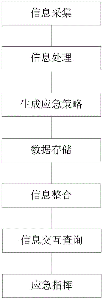
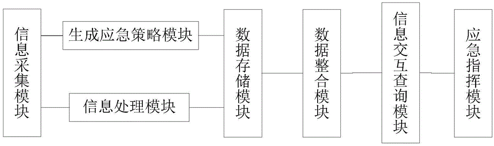
[0046] This embodiment provides a GIS-based three-dimensional emergency command method. The method flow chart is as follows: figure 1 As shown, it specifically includes the following steps:

[0047] Information collection: real-time acquisition of weather information, geographic information and remote acquisition of emergency scene information and power grid information from the weather information database, geographic information database and power grid database. The weather information data includes real-time weather monitoring data, 12 hours and 7 days at a county level Forecast data, refined meteorological element forecast data, short-term nowcast weather forecast data, short-term weather forecast data, medium-term weather forecast data, ten-day weather forecast data, important weather forecast data, geological disaster warning data, forest fire warning data, meteorological disaster warning Data, lightning data, cloud image data, radar data and typhoon data, as well as rich an...

Embodiment 2

[0057] On the basis of the first embodiment, this implementation provides a GIS-based three-dimensional emergency command method, which further includes comparing various weather data with warning values, and if a certain weather data exceeds a preset threshold, sending warning information. Corresponding early warning plans can be made based on the early warning results, and preliminary instructions can be issued in advance for early warning materials to provide a basis for prevention work decisions and improve early warning capabilities.

[0058] As a preferred embodiment, the process of generating an emergency strategy further includes issuing a preparation instruction for early warning materials in advance. While carrying out emergency command, the task list can be sent and the command order can be issued, which improves the decision-making and command ability.

Embodiment 3

[0060] This embodiment is a preferred embodiment. On the basis of the first and second embodiments, the information collection processing further includes: meteorological information analysis: the meteorological data collection interface server receives the data from the meteorological data collection server point-to-point, and Various forms of meteorological data files are classified and analyzed into preset format data and written into the meteorological database server; geographic information analysis: the geographic data collection interface server receives the data from the geographic data collection server point-to-point, and classifies the various forms of geographic data files Parse into preset format data and write it to the geodatabase server; power grid information analysis: the grid data collection interface server receives the data from the grid data collection server point-to-point, classifies and parses various forms of grid data files into preset format data, and ...


PUM


Abstract

The present invention provides a three-dimensional emergency command method and system on the basis of a GIS. The method comprises: collecting emergency scene, meteorology, geography and power grid information in real time, and analyzing preset format data; and storing each types of data, integrating the types of accidents and relevant information to automatically generate an emergency strategy, and performing interaction query after integrating the emergency scene, meteorology, geography and power grid information to provide decision basis for emergency commands. The three-dimensional emergency command method and system on the basis of a GIS is able to perform dynamic collection presentation and linkage interaction query of multi-source data in a three-dimensional scene so as to realize three-dimensional panorama tracking of a first-aid repair task and visually represent the first-aid repair progress of each task, therefore the efficiency of the emergency first-aid repair work and the capability of processing power grid faults are improved, and the urban emergency first-aid repair command scheduling capability is also is improved.

Description

Technical field [0001] The invention relates to a GIS-based three-dimensional emergency command method and its system, in particular to an emergency repair command system applied to electric equipment. It belongs to the field of electronic command technology. Background technique [0002] As we all know, people's three-dimensional vision of objects is produced by binocular parallax, and all optical devices or structures that can make people's binocular parallax can produce three-dimensional vision. Since the emergence of three-dimensional display technology, three-dimensional display methods and technologies have become more and more colorful. Really reproducing three-dimensional (3D) display technology is an important development trend of imaging technology. In the fields of scientific visualization, multimedia display, virtual reality, etc., three-dimensional display technology has important application value. In recent years, three-dimensional display technology has been wid...

Claims


Application Information

Patent Timeline
Patent Type & Authority Applications(China)
IPC IPC(8): G06Q10/06G06Q50/06
CPCG06Q10/06G06Q50/06Y04S10/50
Inventor 公伟勇崔潇徐刚徐鹏贾旭郭英雷
Owner STATE GRID SHANDONG ELECTRIC POWER
Why Eureka
Try Eureka