Air-land integrated car networking system and method for realizing navigation
An Internet of Vehicles, land-air technology, applied in the field of Internet of Vehicles, can solve problems such as traffic hidden dangers, achieve the effect of alleviating traffic congestion, improving transportation efficiency and avoiding traffic congestion routes
- Summary
- Abstract
- Description
- Claims
- Application Information
AI Technical Summary
Problems solved by technology
Method used
Image

Examples
specific Embodiment approach 1
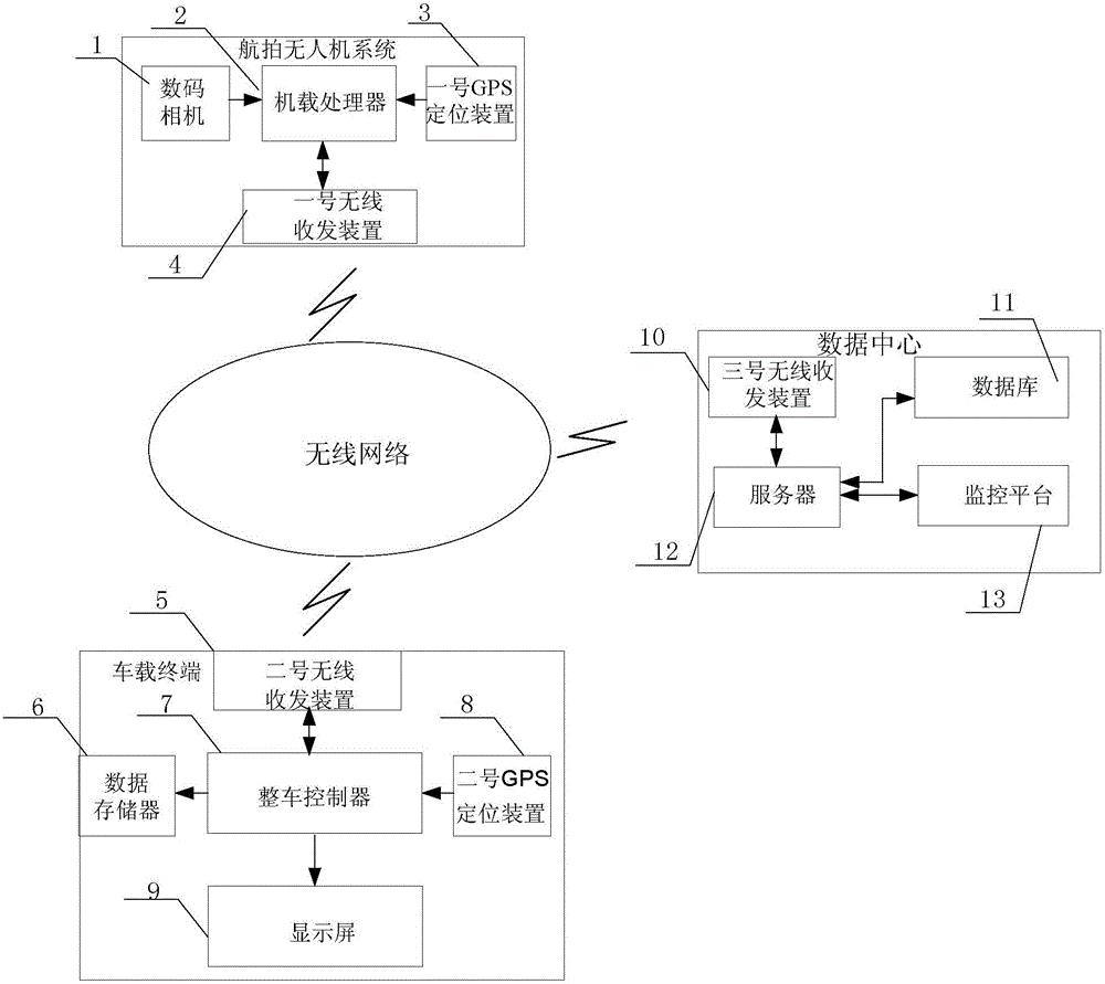
[0029] Specific implementation mode 1. Combination figure 1 Describe this embodiment, the ground-air integrated vehicle networking system described in this embodiment, the system includes an aerial photography UAV system, a data center and a vehicle-mounted terminal, and the aerial photography UAV system includes a digital camera 1, an onboard processor 2, No. 1 GPS is positioned at device 3 and No. 1 wireless transceiver device 4;
[0030] The digital camera 1 is installed on the unmanned aerial vehicle, is used for photographing the image information of the road surface, and sends the photographed image information to the on-board processor 2;
[0031] The on-board processor 2 is used to receive the road surface image information sent by the digital camera 1 and the UAV position information sent by No. 1 GPS positioning device 3, and extract the vehicle position information on the road surface according to the UAV position information and the road surface image information, ...
specific Embodiment approach 2
[0045] Embodiment 2. This embodiment is a further description of the ground-air integrated vehicle networking system described in Embodiment 1. The No. 1 wireless transceiver device 4 and the No. 2 wireless transceiver device 5 both use DTU (DataTransferunit) wireless terminal equipment accomplish.
specific Embodiment approach 3
[0046] Specific implementation mode 3. The method for realizing navigation of the ground-air integrated vehicle networking system described in this implementation mode, the specific steps of the method:
[0047] Step 1: Use the digital camera 1 in the aerial photography UAV to take pictures of road surface image information at a frequency of once per second, and send the image information to the onboard processor 2; use No. 2 GPS positioning device 8 to check the location of the car where the vehicle terminal is located Carry out positioning; and send the destination address information of the vehicle where the vehicle-mounted terminal is located and the vehicle where the vehicle-mounted terminal is located to the data center through the No. 2 wireless transceiver device 5;
[0048] Step 2: The on-board processor 2 compares the received image information with the map corresponding to the image information, obtains the actual position of the vehicle on the road, calculates the a...
PUM
 Abstract
Description
Claims
Application Information
 - Generate Ideas
- Intellectual Property
- Life Sciences
- Materials
- Tech Scout
- Unparalleled Data Quality
- Higher Quality Content
- 60% Fewer Hallucinations
Browse by: Latest US Patents, China's latest patents, Technical Efficacy Thesaurus, Application Domain, Technology Topic, Popular Technical Reports.
© 2025 PatSnap. All rights reserved.Legal|Privacy policy|Modern Slavery Act Transparency Statement|Sitemap|About US| Contact US: help@patsnap.com