Two-machine intersection positioning method based on airborne opto-electronic platform

A rendezvous positioning and photoelectric platform technology, applied in the direction of measuring devices, instruments, surveying and navigation, etc., can solve the problems of limited applicability, affecting the practicality of the battlefield, and cannot guarantee real-time positioning, so as to achieve high applicability and increase the use distance Range, high mobility effects

Inactive Publication Date: 2017-03-01
CHANGCHUN INST OF OPTICS FINE MECHANICS & PHYSICS CHINESE ACAD OF SCI
View PDF1 Cites 19 Cited by
  • Summary
  • Abstract
  • Description
  • Claims
  • Application Information

AI Technical Summary

Problems solved by technology

However, this method can only be used to locate static targets on the ground. In practical applications, it is often necessary to locate moving targets on the ground or flying targets in the air. Therefore, the applicability o

Method used


Image

  • Two-machine intersection positioning method based on airborne opto-electronic platform
  • Two-machine intersection positioning method based on airborne opto-electronic platform
  • Two-machine intersection positioning method based on airborne opto-electronic platform

Examples


Example Embodiment

[0037] The present invention will be described in detail below with reference to the drawings and embodiments.

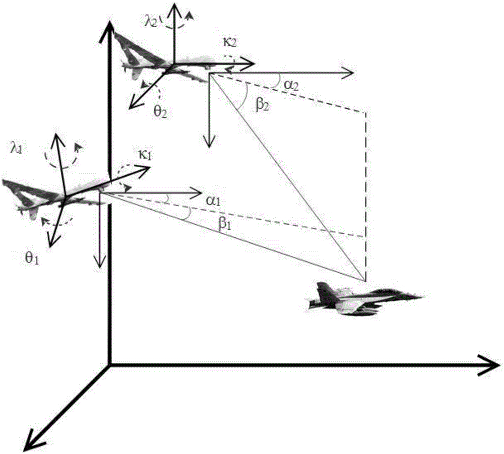
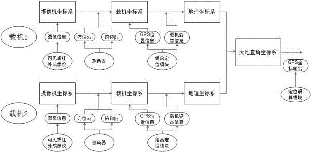
[0038] The invention provides a dual-aircraft rendezvous positioning method based on an airborne optoelectronic platform. Two drones are used to locate stationary or mobile targets, such as figure 1 As shown, the airborne optoelectronic platforms of the two UAVs are equipped with infrared thermal imaging cameras, visible light cameras, goniometers, signal processing units and communication modules. The signal processing unit has established signal connections with each device. It is used to collect measurement data and calculate the target position, and the communication module is used to receive and send measurement data. The positioning method is shown in 2, which specifically includes the following steps:

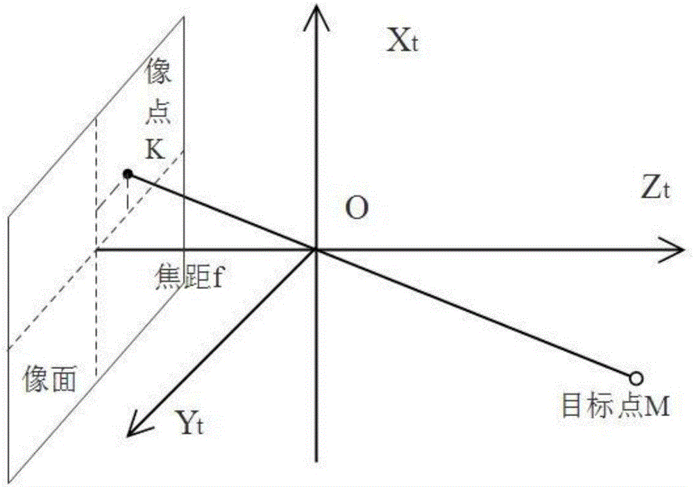
[0039] Step 1. Establish auxiliary coordinate system: camera coordinate system, carrier coordinate system, carrier geographic coordinate system, geodetic rectangu...


PUM


Abstract

The invention discloses a two-machine intersection positioning method based on an airborne opto-electronic platform. The method can realize whole-course target tracking positioning, and can complete real-time positioning of a static state or dynamic target. The method firstly establishes a camera coordinate system, a carrier coordinate system, a carrier geography coordinate system, a geodetic rectangular coordinate system and a geodetic coordinate system, the a camera of two machines is used for simultaneous imaging the target, the target visual line vector quantity of each carrier enables cosine expression along the direction below the camera coordinate system; by coordinate transition, the obtained target visual line vector quantity of each carrier enables cosine expression along the direction below the geodetic rectangular coordinate system, then a carrier coordinate is combined to establish a linear equation, and the positioning on the target is realized by two simultaneous linear equations. The distance between the target and the platform is not required for measuring, assembling of a laser range finder is not required in a photoelectric platform, loading of the carrier is effectively reduced, and the requirements of real-time performance and mobility are satisfied.

Description

technical field [0001] The invention relates to the technical field of airborne optical measurement target positioning, in particular to a dual-aircraft rendezvous positioning method based on an airborne photoelectric platform. Background technique [0002] As an important tool in the field of reconnaissance and positioning, the optical measurement equipment of the shooting range plays an important role in military and civilian applications. According to different bases, modern optical measurement equipment can be mainly divided into ground photoelectric theodolite, offshore survey ship and airborne photoelectric platform. In practical applications, due to the influence of factors such as the position and motion characteristics of the target, the radius of curvature of the earth, and the linearity of light propagation, the working distance between the ground photoelectric theodolite and the marine survey ship is limited, thus restricting the full potential of photoelectric e...

Claims


Application Information

Patent Timeline
IPC IPC(8): G01C21/00G01C11/00
CPCG01C21/005G01C11/00
Inventor 刘晶红白冠冰宋悦铭熊文卓
Owner CHANGCHUN INST OF OPTICS FINE MECHANICS & PHYSICS CHINESE ACAD OF SCI
Why Eureka
Try Eureka