Supercharge Your Innovation With Domain-Expert AI Agents!

Method for enhancing high-resolution remote sensing image road in constrained path morphologic way

A remote sensing image, high-resolution technology, applied in image enhancement, image analysis, image data processing, etc., can solve problems such as lack of mature and reliable processes, and achieve increased length accuracy and rotational invariance, enhanced completeness, and algorithm time complexity. and the effect of space complexity simplification

Active Publication Date: 2017-03-15
CHINA HIGHWAY ENG CONSULTING GRP CO LTD +1
View PDF4 Cites 7 Cited by
  • Summary
  • Abstract
  • Description
  • Claims
  • Application Information

AI Technical Summary

Problems solved by technology

In recent years, although many methods have been proposed in the research field of automatic road extraction from remote sensing images, there is still no mature and reliable process

Method used


Image

  • Method for enhancing high-resolution remote sensing image road in constrained path morphologic way
  • Method for enhancing high-resolution remote sensing image road in constrained path morphologic way
  • Method for enhancing high-resolution remote sensing image road in constrained path morphologic way

Examples


Embodiment Construction

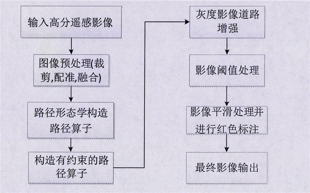
[0047] The present invention takes a high-resolution remote sensing image (which has been converted into a gray-scale image) as an example to illustrate the specific implementation of a road enhancement method for a high-resolution remote sensing image with restricted path morphology. The experimental image is a high-resolution remote sensing road image in the suburbs of the city, such as Figure 5 shown. The present invention will be further described below in conjunction with the accompanying drawings.

[0048] Such as figure 1 As shown, it is a flow chart of the restricted path morphology enhanced high-resolution remote sensing image road in the embodiment of the present invention. This embodiment includes the following steps:

[0049] Step 1. Perform image preprocessing on high-resolution remote sensing images, including image cropping, image registration, and image fusion.

[0050] Use ENVI software to cut out the region of interest to reduce the amount of calculation...


PUM


Abstract

The invention relates to a method for enhancing a high-resolution remote sensing image road in a constrained path morphologic way. The method comprises the following steps: inputting a high-resolution remote sensing image (mainly a high-resolution second remote sensing image), performing image preprocessing including image cutting, image registration, and image fusion to obtain a to-be-processed image with heavy contrast; constructing a set of path operators composed of elongated and oriented structural elements by using a path morphological method, constructing a constrained path operator on this basis, ordering the pixel values of a grayscale image in an ascending order and successively binarizing the pixel values as thresholds, enhancing road information by extracting the linear-like information from the binary image by using the path operator; and finally, subjecting the enhanced road image to threshold processing and appropriate smoothening and marking the enhanced road image with red color so as to obtain a complete enhanced road image with a good effect. The method can effectively identify the road information in the high-resolution remote sensing image and provide auxiliary information for road change detection.

Description

technical field [0001] The invention belongs to the technical field of remote sensing image processing, and mainly relates to a path morphology method in the image processing technology, in particular to an improved path morphology enhancement method for road information in images. Background technique [0002] Foreign research on road detection and recognition can be traced back to the 1970s. Due to the relatively backward development of domestic satellite remote sensing launch technology and computer technology, the research on remote sensing road detection and recognition developed relatively late, probably starting in the mid-1980s. later stage. In recent years, with the rapid development of space technology and sensor technology, remote sensing information has become an indispensable geographic information data source, and remote sensing continues to develop in the direction of high spatial resolution, high spectral resolution and high temporal resolution. Due to the r...

Claims


Application Information

Patent Timeline
Patent Type & Authority Applications(China)
IPC IPC(8): G06T5/40
CPCG06T5/40G06T2207/10032G06T2207/20036G06T2207/20172
Inventor 王国锋张蕴灵李建成孟瑜岳安志黄滢卢思佳
Owner CHINA HIGHWAY ENG CONSULTING GRP CO LTD
Features
  • R&D
  • Intellectual Property
  • Life Sciences
  • Materials
  • Tech Scout
  • Unparalleled Data Quality
  • Higher Quality Content
  • 60% Fewer Hallucinations
Learn More