Inertial measurement unit and geomagnetic sensor integrated calibration apparatus and calibration method

An inertial measurement unit and geomagnetic sensor technology, applied in the field of navigation, can solve the problems of low measurement accuracy, complex calibration methods, and high cost of calibration equipment, and achieve the effects of reducing costs, improving accuracy and reliability, and avoiding mechanical installation.

Inactive Publication Date: 2017-05-10
CHANGCHUN INST OF OPTICS FINE MECHANICS & PHYSICS CHINESE ACAD OF SCI
View PDF4 Cites 16 Cited by
  • Summary
  • Abstract
  • Description
  • Claims
  • Application Information

AI Technical Summary

Problems solved by technology

[0004] In order to solve the problems of high cost of calibration equipment for existing inertial measurement units, complex calibration methods, and low measurement accuracy due to errors in the compensation technology of existing geomagnetic sensors, the present invention provides an integral calibration device and calibration of inertial measurement units and geomagnetic sensors. method

Method used


Image

  • Inertial measurement unit and geomagnetic sensor integrated calibration apparatus and calibration method
  • Inertial measurement unit and geomagnetic sensor integrated calibration apparatus and calibration method
  • Inertial measurement unit and geomagnetic sensor integrated calibration apparatus and calibration method

Examples


specific Embodiment approach 1

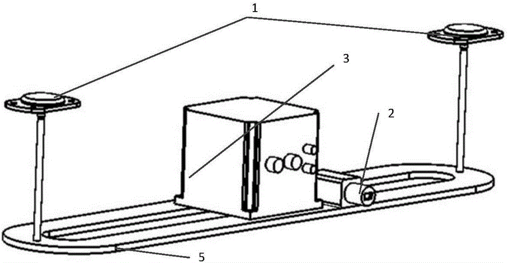
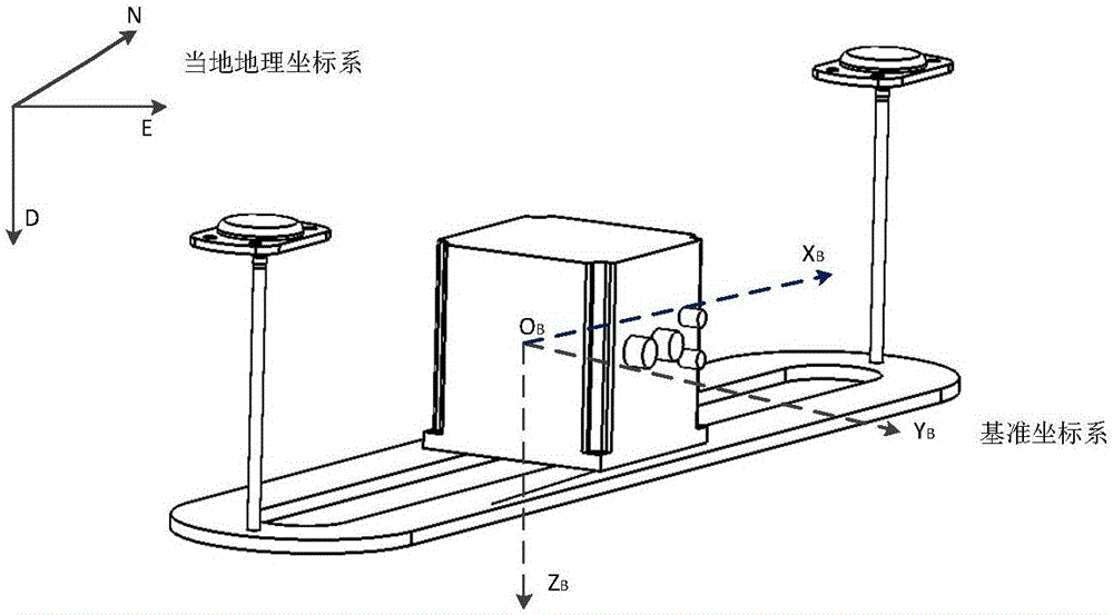
[0028] Specific implementation mode 1. Combination Figure 1 to Figure 6 To illustrate this embodiment, the inertial measurement unit and the overall calibration device of the geomagnetic sensor are combined figure 1This embodiment is described, including a set of dual-antenna GNSS / SINS high-precision integrated navigation system, a telephoto high-resolution industrial camera 2 and a calibration hexahedron tooling 4 . Each surface of the hexahedral tooling is coated with a high-precision two-dimensional square augmented reality cooperation target with different IDs. The high-precision integrated navigation system and the high-resolution industrial camera are fixed through the metal plate pole 5, and the baseline length between the antennas is guaranteed to be more than 1.5m to ensure that the noise of the reference heading angle is kept at a small level. The dual-antenna GNSS / SINS high-precision integrated navigation system is used as the benchmark test equipment for the tran...

specific Embodiment approach 2

[0039] Specific embodiment two, combine Figure 7 Describe this embodiment, this embodiment is the calibration method of the inertial measurement unit and the geomagnetic sensor overall calibration device described in the first specific embodiment, and its specific calibration process is as follows:

[0040] 1. Place the reference navigation system and the calibration hexahedron on the same horizontal plane. In order to ensure the measurement accuracy, minimize the distance between the camera and the hexahedron;

[0041] 2. Establish the calibration model of the sensor of the measured object,

[0042] The model of the accelerometer is

[0043]

[0044] in, is the specific force after calibration; is the specific force of the original output of the accelerometer; b a is the zero bias of the accelerometer, w a Indicates the accelerometer noise level; K a is the matrix of accelerometer scale factors and mounting coupling coefficients.

[0045] The calibration model of...


PUM


Abstract

An inertial measurement unit and geomagnetic sensor integrated calibration apparatus and a calibration method. The invention relates to the technical field of navigation and solves the problems of high calibration device cost and complex calibration methods for an inertial measurement unit in the prior art, and low measurement precision in a compensation technology for a geomagnetic sensor due to error. In the apparatus, a high-resolution long-focus industrial camera is fixedly connected to a dual-antenna GNSS / SINS combined navigation system. The calibration method includes the steps of: 1) measuring position of earth system and an attitude angle of local geo-system by means of the basic combined navigation system; 2) referring to a table to find a theoretical geomagnetic field intensity value, calculating theoretical specific force and angular speed, and calculating the nominal value of a calibrated object on a carrier system through optical reference transmission; 3) collecting measurement values of the to-be-tested IMU and the geomagnetic sensor, optionally arranging a hexahedral tooling to obtain a plurality sets of nominal values and measurement values of the calibrated object, establishing an equation group, and calculating calibration parameters to complete calibration. The apparatus and the method avoid direct mechanical installation and serious electromagnetic interference on the geomagnetic sensor due to the calibration apparatus, and improve accuracy and reliability of the calibration of the geomagnetic sensor.

Description

technical field [0001] The invention relates to the technical field of navigation, in particular to an integral calibration device for an inertial device and a geomagnetic sensor and a calibration method thereof. Background technique [0002] Inertial measurement units (IMUs) and geomagnetic sensors are widely used in consumer electronics such as smartphones, and robotic systems such as drones and self-driving cars. The IMU is the basic measurement device for inertial navigation. It is composed of a three-axis gyroscope and a three-axis accelerometer. It is fixed on the carrier to realize the perception of the angular velocity and specific force of the carrier. position, velocity and attitude angle. However, the accuracy of civilian inertial devices is poor, and it is difficult to measure and align azimuth angles. Therefore, a three-axis geomagnetic sensor (such as a fluxgate sensor and a magnetoresistive sensor, etc.) is used to sense the local magnetic field strength and...

Claims


Application Information

Patent Timeline
Patent Type & Authority Applications(China)
IPC IPC(8): G01C25/00
CPCG01C25/005
Inventor 王延东张恩阳马经纬
Owner CHANGCHUN INST OF OPTICS FINE MECHANICS & PHYSICS CHINESE ACAD OF SCI
Why Eureka
Try Eureka