Algorithm for performing flood-caused diarrhea outbreak risk remote sensing diagnosis by utilizing remote sensing data and expert knowledge base

An expert knowledge base and remote sensing data technology, applied in the field of remote sensing diagnosis of diarrhea outbreak risk caused by floods, can solve problems such as time-consuming, difficult to expand to large-scale areas, and inability to obtain relevant data, so as to reduce workload and reduce medical security Costs, morbidity and mortality reduction effects

Inactive Publication Date: 2017-05-31
INST OF REMOTE SENSING & DIGITAL EARTH CHINESE ACADEMY OF SCI
View PDF0 Cites 3 Cited by
  • Summary
  • Abstract
  • Description
  • Claims
  • Application Information

AI Technical Summary

Problems solved by technology

[0005] Using the traditional time-series analysis method based on historical incidence data to predict the risk of diarrheal disease outbreaks caused by floods Due to historical reasons, it is not only impossible to obtain the latest series of relevant data caused by floods, but also requires drinking water managers to identify and quantify pathogens in water Effect of Concentration Fluctuation on Diarrheal Disease
This makes traditional methods not only costly and time-consuming, but also difficult to extend to large-scale areas

Method used


Image

  • Algorithm for performing flood-caused diarrhea outbreak risk remote sensing diagnosis by utilizing remote sensing data and expert knowledge base
  • Algorithm for performing flood-caused diarrhea outbreak risk remote sensing diagnosis by utilizing remote sensing data and expert knowledge base
  • Algorithm for performing flood-caused diarrhea outbreak risk remote sensing diagnosis by utilizing remote sensing data and expert knowledge base

Examples


Embodiment Construction

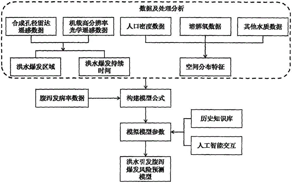
[0015] figure 1 It is a flow chart of constructing the remote sensing diagnosis algorithm model of flood-induced diarrhea outbreak risk. As can be seen from the figure, building a cholera prediction model includes the following three steps:

[0016] 1) Use satellite remote sensing data (SAR and airborne high-resolution optical remote sensing data) to obtain flood outbreak area and flood outbreak duration data information; use inverse distance weighting difference based on population density data, dissolved oxygen data and other water quality survey data The algorithm (IDW) analyzes and solves the spatial distribution characteristics of these data;

[0017] 2) Construct a model formula based on the relationship between the flood information obtained from the above remote sensing data and the environmental elements and the diarrhea incidence data;

[0018] 3) The expert system is used to fit the model based on the historical data of the risk of diarrheal disease outbreaks caus...


PUM


Abstract

The invention discloses an algorithm for performing flood-caused diarrhea outbreak risk remote sensing diagnosis by utilizing remote sensing data and an expert knowledge base. The algorithm disclosed by the invention comprises the following steps: (1) dividing a flooded area by utilizing multi-temporal and different resolution remote sensing data; (2) obtaining flood continuous distribution characteristics through synthetic aperture radar remote sensing data based on long time series and a GIS Overlay analysis technology; (3) analyzing by utilizing an inverse distance weight difference algorithm and resolving to obtain dissolved oxygen, infected people, death toll and other spatial distribution characteristics; (4) establishing a flood-caused diarrhea outbreak risk fitting model by utilizing an expert system diagnosis algorithm, analyzing a relation among all variables, resolving to obtain model parameters and obtaining a final flood-caused diarrhea outbreak risk remote sensing diagnosis model. The invention forms a model method capable of quickly providing diarrhea outbreak risk forecast for residents in a flood prone area. Through the method, high-precision forecast can be performed on diarrhea outbreak risks, so that the morbidity and the mortality of patients in a disaster area are reduced.

Description

technical field [0001] The invention relates to a method for remote sensing diagnosis of diarrhea outbreak risk caused by flood, in particular to an algorithm for remote sensing diagnosis of diarrhea outbreak risk caused by flood by using remote sensing data and an expert knowledge base. Background technique [0002] Diarrheal disease is a group of intestinal infectious diseases caused by different pathogens. It is a global public health problem. The risk prediction and control level of its outbreak is an important reflection of the social system and economic civilization. Diarrhea caused by floods, due to time constraints, heavy tasks, inconvenient transportation, and complicated epidemic factors during the flood season, the comprehensive prediction and control effects are often unsatisfactory. [0003] The traditional flood-induced diarrheal disease outbreak risk prediction method is mainly based on the time-series analysis method of historical incidence data. This method ...

Claims


Application Information

Patent Timeline
Patent Type & Authority Applications(China)
IPC IPC(8): G06F19/00
CPCG16H50/80
Inventor 曹春香韩伟旗倪希亮刘迪帕特里夏
Owner INST OF REMOTE SENSING & DIGITAL EARTH CHINESE ACADEMY OF SCI
Why Eureka
Try Eureka