Regional phreatic water evaporation capacity measurement method and device based on digital elevation model

A digital elevation model and measurement method technology, applied in the field of data processing, can solve problems such as only single-point data, lack of experimental data in the research area, and inability to guarantee accuracy, so as to achieve simple and clear implementation steps, save manpower and material resources, and data acquisition simple effect

Inactive Publication Date: 2017-06-13
XINJIANG INST OF ECOLOGY & GEOGRAPHY CHINESE ACAD OF SCI
View PDF1 Cites 0 Cited by
  • Summary
  • Abstract
  • Description
  • Claims
  • Application Information

AI Technical Summary

Problems solved by technology

Satellite remote sensing is limited by ground calibration, and it still cannot guarantee sufficient accuracy
Theoretical derivation is universal. However, in actual calculation, more detailed data and long-term experimental data support are often required to perform calculations. There are also difficulties and bottlenecks in the establishment and understanding of models.
In practical applications, due to actual conditions and limitations of manpower and material resources, many research areas often lack d...

Method used


Image

  • Regional phreatic water evaporation capacity measurement method and device based on digital elevation model
  • Regional phreatic water evaporation capacity measurement method and device based on digital elevation model
  • Regional phreatic water evaporation capacity measurement method and device based on digital elevation model

Examples


Embodiment Construction

[0046] Embodiments of the present invention will be described in detail below with reference to the accompanying drawings.

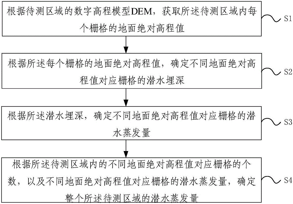
[0047] Such as figure 1 As shown, the embodiment of the present invention provides a method for measuring regional phreatic evaporation based on a digital elevation model, the method comprising the following steps:

[0048] S1: According to the DEM model (digital elevation model) of the area to be measured, obtain the ground absolute elevation value of each grid in the area to be measured;

[0049] Specifically, the DEM model of the area to be measured is a known quantity, and the DEM model realizes the digital simulation of the terrain surface through limited terrain elevation data (that is, the digital expression of the terrain surface shape), which is represented by a set of ordered numerical arrays A solid ground model of ground elevation. In other words, the DEM model can reflect the absolute ground elevation value H of the area to be measured L ...


PUM


Abstract

The invention relates to a regional phreatic water evaporation capacity measurement method and device based on a digital elevation model. The method comprises the steps that ground absolute elevation values of all grids in a to-be-measured region are acquired according to the digital elevation model (DEM) of the to-be-measured region; the groundwater depths of the grids corresponding to different ground absolute elevation values are determined according to the ground absolute elevation values of all the grids; the phreatic water evaporation capacities of the grids corresponding to the different ground absolute elevation values are determined according to the groundwater depths; the phreatic water evaporation capacity of the whole region is determined according to the number of the grids corresponding to the different ground absolute elevation values in the to-be-measured region and the phreatic water evaporation capacities of the grids corresponding to the different ground absolute elevation values. According to the technical scheme, the measurement result is high in accuracy, little data is needed, data acquisition is easy, the implementation steps are simple and clear, and manpower and material resources of site investigation can be greatly saved.

Description

technical field [0001] The invention relates to the technical field of data processing, in particular to a method and device for measuring regional phreatic evaporation based on a digital elevation model. Background technique [0002] At present, groundwater environmental impact assessments such as water resources assessment, foundation pit precipitation, and mining dewatering involve fields such as groundwater development and utilization, groundwater replenishment and drainage, and require the establishment of numerical models of groundwater in corresponding areas. In the process of establishing the groundwater numerical model, in addition to the physical characteristics of the aquifer, it is also necessary to grasp the hydrogeological parameters of the area to be evaluated. Hydrogeological parameters are crucial to groundwater flow problems. Among the hydrogeological parameters, evaporative discharge is the most important way of groundwater discharge, especially in arid r...

Claims


Application Information

Patent Timeline
IPC IPC(8): G06F19/00
CPCG16Z99/00
Inventor 范敬龙魏亚平徐新文雷加强李生宇李丙文常青王海峰王永东靳正忠王晓静李存娟
Owner XINJIANG INST OF ECOLOGY & GEOGRAPHY CHINESE ACAD OF SCI
Why Eureka
Try Eureka