Method for monitoring and calculating settlement of coal mining surface based on unmanned aerial vehicle remote sensing
A surface subsidence and unmanned aerial vehicle technology, applied in photogrammetry/video surveying, measuring device, surveying and navigation, etc., to achieve the effect of low input cost, short monitoring period and high monitoring accuracy
- Summary
- Abstract
- Description
- Claims
- Application Information
AI Technical Summary
Problems solved by technology
Method used
Image

Examples
Embodiment Construction
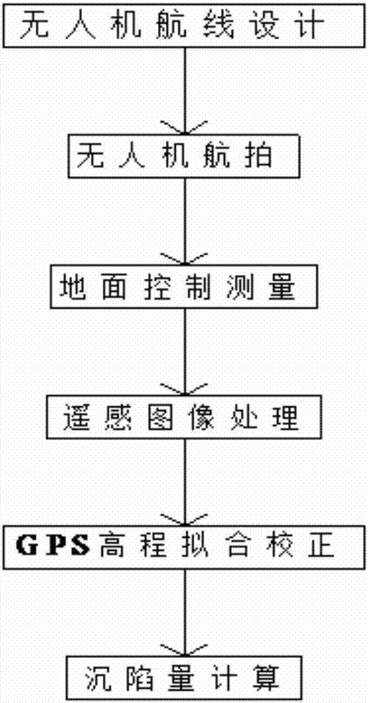
[0050] Such as figure 1 A method of monitoring and calculating coal mining surface subsidence based on UAV remote sensing is shown. Taking the application of 805 fully mechanized mining face in a mine in Ningdong Coal Base as an example, a small UAV is used to monitor the surface subsidence in the coal mining subsidence area. Quantities are calculated as follows.
[0051] Step 1. UAV route design: Plan the UAV flight route according to the topography, range, position and ground resolution of the research area.
[0052] The embodiment of the present invention adopts the MD4-1000 four-rotor aerial photography dedicated small unmanned aerial vehicle, and the sensor adopts the SONY A7R camera produced by Sony Corporation of Japan. The flight route of the small unmanned aerial vehicle mainly includes flight height, overlap rate and heading design, as follows:
[0053] Step 101. Determination of flying height: Determine the size of the ground resolution GSD according to the width o...
PUM
 Abstract
Description
Claims
Application Information
 - R&D
- Intellectual Property
- Life Sciences
- Materials
- Tech Scout
- Unparalleled Data Quality
- Higher Quality Content
- 60% Fewer Hallucinations
Browse by: Latest US Patents, China's latest patents, Technical Efficacy Thesaurus, Application Domain, Technology Topic, Popular Technical Reports.
© 2025 PatSnap. All rights reserved.Legal|Privacy policy|Modern Slavery Act Transparency Statement|Sitemap|About US| Contact US: help@patsnap.com