Unmanned plane video image target positioning system and method and holder control method

A target positioning and UAV technology, applied in the field of UAV PTZ control, can solve the problems of inability to obtain and display video, inconvenient operation, etc., and achieve the effect of simplifying control strategies, simplifying operations, and improving work efficiency

Inactive Publication Date: 2017-10-13
THE 28TH RES INST OF CHINA ELECTRONICS TECH GROUP CORP
View PDF7 Cites 46 Cited by
  • Summary
  • Abstract
  • Description
  • Claims
  • Application Information

AI Technical Summary

Problems solved by technology

[0007] Existing UAV operating systems, such as DJI, usually can only display the position coordinates of the UAV itself and the general orientation of the gimbal on the map during the flight of the UAV, and cannot obtain and display the information in the video. The location of the captured target; on the other hand, when the target in the designated area needs to be reconnaissance, the existing UAV operating system needs to manually adjust the pan / tilt, and can only rely on the real-time returned video to manually judge the pan / tilt control direction, operation is extremely inconvenient

Method used


Image

  • Unmanned plane video image target positioning system and method and holder control method
  • Unmanned plane video image target positioning system and method and holder control method
  • Unmanned plane video image target positioning system and method and holder control method

Examples


Embodiment Construction

[0051] The present invention will be described in further detail below in conjunction with the accompanying drawings.

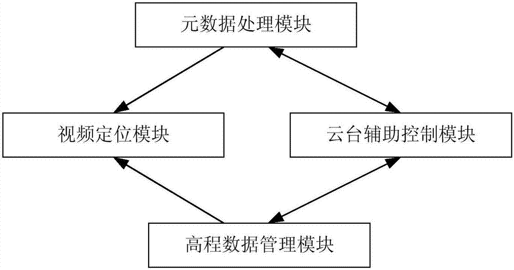
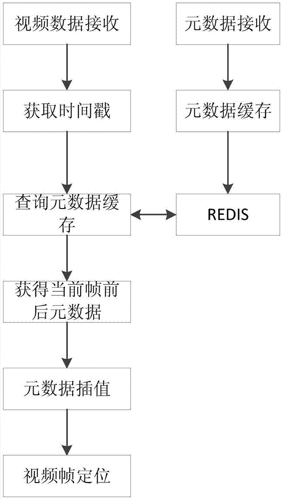
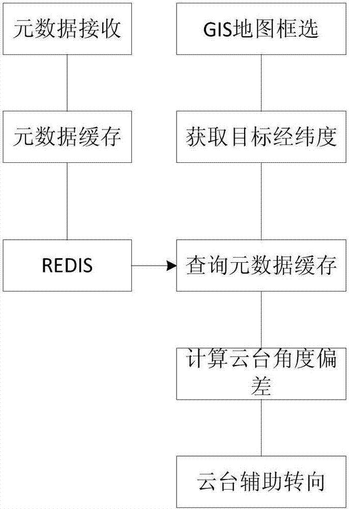
[0052] Such as figure 1 As shown, the metadata-based UAV video image target positioning system in the present invention includes a metadata processing module, an elevation data management module, a video positioning module, and a cloud platform auxiliary control module; the metadata processing module is responsible for receiving unmanned aerial vehicles in real time. The returned flight data and load data, and extract the longitude and latitude, altitude, pitch angle, azimuth angle, roll angle of the UAV and the pitch angle, azimuth angle of the gimbal, the horizontal field of view angle of the sensor, and the vertical field of view angle , video resolution and other metadata information; the elevation data management module is responsible for storing and accessing the elevation data of a large area in blocks, converting the block DEM data into the geocentric...


PUM


Abstract

The invention discloses an unmanned plane video image target positioning system and method based on metadata and a holder control method and solves a problem that the position of a shot target of a video can not be acquired and displayed in the prior art. In combination with the target area position and the position and flight parameters of an unmanned plane, holder orientation and a pitch angle parameter are solved in real time, the target in the video is positioned, the target is assigned through frame selection of the video returned by the unmanned plane in an unmanned plane flight process, target positioning is supported, and the target area acquired through frame selection is displayed in a GIS map in real time. The method is advantaged in that a problem of inconvenience in manually adjusting a holder in the prior art is solved, point clicking on the GIS map to assign the target is supported, according to the unmanned plane, the target position, the flight parameter and the elevation data information, holder parameters are solved, the holder is controlled for rotation, and the target is made to be at a sensor vision axis center.

Description

technical field [0001] The invention belongs to the field of UAV target positioning and video image processing, and in particular relates to a metadata-based UAV video image target positioning system, a positioning method and a UAV cloud platform control method. Background technique [0002] UAV (Unmanned Aerial Vehicle, UAV), as a new type of modern military equipment, with its unique "unmanned" advantage, fully conforms to the modern warfare concept of "no meeting" and "zero casualties". By carrying different equipment, drones can perform tasks such as reconnaissance and surveillance, laser guidance, electronic jamming, communication relay, target positioning, combat assessment, and precision strikes. UAVs are also promising for civilian use. They can be used in field monitoring, weather detection, highway inspection, surveying and mapping, flood monitoring, aerial photography, traffic management, power line inquiries, forest fire prevention and rescue, etc. [0003] In r...

Claims


Application Information

Patent Timeline
Patent Type & Authority Applications(China)
IPC IPC(8): G05D1/08
CPCB64G1/244
Inventor 郭乔进梁中岩李若垚宫世杰时高山祁骏许建胡杰陈文明孟剑萍
Owner THE 28TH RES INST OF CHINA ELECTRONICS TECH GROUP CORP
Why Eureka
Try Eureka