Embedded GPS and BDS combined real-time precise single point positioning equipment

A precision single-point positioning and embedded technology, which is applied in satellite radio beacon positioning systems, measuring devices, instruments, etc., can solve the problems of application limitations, weaken the influence of errors, increase operating costs and complexity, and reduce operating costs. The effects of cost, improved positioning accuracy, and reduced convergence time

Inactive Publication Date: 2017-10-24
SOUTHEAST UNIV
View PDF4 Cites 12 Cited by
  • Summary
  • Abstract
  • Description
  • Claims
  • Application Information

AI Technical Summary

Problems solved by technology

The data of the entire reference station network is uniformly calculated by the data processing center. By forming double-difference observations, public errors such as receiver clock error and satellite clock error are eliminated, and the influence of errors caused by strong correlations such as tropospheric delay and ionospheric delay is weakened, so as to realize centimeter This technology has been widely used in the engineering field. Since the network RTK technology needs to set up a continuous operation reference station system before it is used, two receivers are required for synchronous observation during operation. Models can provide high-precision positioning services, which not only increases the operating cost and complexity, but also limits many applications

Method used


Image

  • Embedded GPS and BDS combined real-time precise single point positioning equipment
  • Embedded GPS and BDS combined real-time precise single point positioning equipment
  • Embedded GPS and BDS combined real-time precise single point positioning equipment

Examples


Embodiment 1

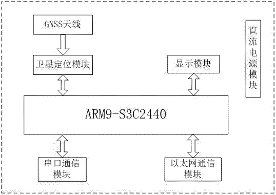
[0031] Embodiment 1: A kind of embedded GPS and BDS combination real-time precision single-point positioning equipment, its ARM core board is respectively connected to power supply module, Ethernet module, serial port module, satellite positioning module, display module, wherein the satellite positioning module is externally connected with GNSS antenna, The GNSS antenna can receive real-time satellite signals, convert electromagnetic wave signals into high-frequency current signals and send them to the satellite positioning module, generate binary format raw data through the process of modulation and demodulation, and use the raw data as input for subsequent positioning research and development. The network module can obtain GPS and BDS real-time satellite orbit and clock correction information and real-time ionospheric information in real time. In addition, it can also transfer files with the local PC through tftp. The serial communication module is mainly used for data related...

Embodiment 2

[0032]Embodiment 2: the main control chip on the ARM core board is the S3C2440 of the ARM series, which is a RISC microprocessor based on the ARM920T core, realizes the MMU, AMBA, BUS and Harvard high-speed buffer structure, and has an independent 16KB instruction Cache And 16KB data Cache, Nand Flash and SDRAM are integrated on the ARM core board. The Nand Flash memory model used is K9F2G08, its size is 256MB, it is a non-volatile memory, and it is mainly used to store system software such as u-boot, kernel, root file system, satellite antenna, tide files, SDRAM required for platform operation Two 32M EM63A165TS-6GZ are used as the memory, which provides a good working environment for the stable operation of the system and the efficient execution of the application layer software.

Embodiment 3

[0033] Embodiment 3: the satellite positioning module uses the UB380 board of Unicore, which can provide the original data of the eight frequency points of the BDS / GPS / GLONASS three systems, which is better than the carrier phase observation value of 1mm. The board is connected to the processor through a 2*16 socket pins on the hardware backplane. These 32 socket pins include 3 serial ports, 1 network port and the corresponding power supply pins of the satellite board. The COM1 of the satellite board is directly led out through the serial port, which is used to set the data format of the board, and the other two serial ports are respectively connected to the two serial ports of the ARM processor, and are used to provide satellite data to the processor.


PUM


Abstract

The invention discloses embedded GPS and BDS combined real-time precise single point positioning equipment. A hardware platform is based on the ARM9 series S3C2440 acting as a master control chip so that the resolving real-time performance and effectiveness of positioning can be guaranteed; an unicorecomm UB380 satellite board card is integrated, the work principle and the circuit design of each module are analyzed and researched, and a hardware framework including a power supply module, a network module, a serial port module, a satellite positioning module and a display module is established; and a Linux operating system is transplanted on the basis of the hardware platform, the embedded GPS / BDS real-time precise single point positioning software is developed accordingly, enhancement information is acquired in real time through the network to calculate the real-time satellite precise orbit and clock error, the error of the signal propagation process is corrected and eliminated through an error model, precise single point positioning is completed by Kalman filtering and the static centimeter level and dynamic decimeter level positioning accuracy can be realized so that the engineering cost can be effectively reduced and the social and economic benefit can be greatly enhanced.

Description

[0001] Field [0002] The invention relates to a real-time dynamic single-point positioning technology, which belongs to the field of global navigation satellite system (GNSS) high-precision positioning technology, in particular to an embedded GPS and BDS combined real-time precise single-point positioning device. Background technique [0003] At present, the most commonly used GNSS high-precision positioning mode is relative positioning, that is, two or more stations are required for synchronous observation during positioning, and the precise coordinates of at least one station in positioning are known to determine the unknown position. The relative position of the site to known sites. In high-precision relative positioning, the most commonly used positioning technology is carrier phase difference technology, that is, RTK technology. Network RTK technology is a new generation of real-time dynamic positioning technology developed on the basis of Internet, wireless communicati...

Claims


Application Information

Patent Timeline
Patent Type & Authority Applications(China)
IPC IPC(8): G01S19/37
Inventor 潘树国韩啸赵庆赵鹏飞
Owner SOUTHEAST UNIV
Why Eureka
Try Eureka