Method for measuring canopy gap three-dimensional structure based on laser radar

A technology of laser radar and three-dimensional structure, applied in the direction of measuring device, electromagnetic wave reradiation, radio wave measurement system, etc., can solve the problems of not being able to obtain the three-dimensional structure characteristics of forest gaps, and the measurement accuracy of small forest gaps is not high

Active Publication Date: 2017-12-15
CENTRAL SOUTH UNIVERSITY OF FORESTRY AND TECHNOLOGY
View PDF4 Cites 11 Cited by
  • Summary
  • Abstract
  • Description
  • Claims
  • Application Information

AI Technical Summary

Problems solved by technology

The biggest advantage of the aerial photo method is that it can quickly identify and measure the area of ​​a large number of gaps in the forest at the landscape scale, but it cannot obtain the three-dimensional structural characteristics of the gaps. Measurement accuracy is not high

Method used


Image

  • Method for measuring canopy gap three-dimensional structure based on laser radar
  • Method for measuring canopy gap three-dimensional structure based on laser radar
  • Method for measuring canopy gap three-dimensional structure based on laser radar

Examples


Embodiment 1

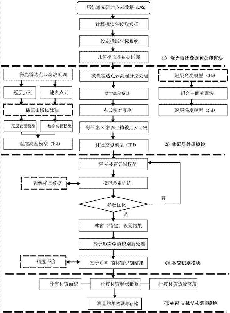
[0083] Embodiment 1: as Figure 1-12 , the specific implementation is divided into 4 steps:

[0084] (1) Laser radar data preprocessing module

[0085] (1) Read the original laser point cloud data (LAS format), and obtain the x-axis value, y-axis value, z-axis value, and echo intensity of each point cloud. (2) Set the projected coordinate system as the Mercator projection (UTM), the reference ellipsoid as WGS84, and the projection zone number T converted from the central longitude of the survey area. (3) Using the error analysis of the overlapping area between the flight belts based on the data itself, the positioning accuracy of the point cloud data is improved, and the deformation of the flight belts is corrected. Secondly, the systematic error is eliminated for each flight belt data, so that the average elevation difference between the flight belts Between -2 and 2 cm.

[0086] A fixed-wing aircraft or UAV equipped with a lidar scanner is used to obtain remote sensing da...

Embodiment (2

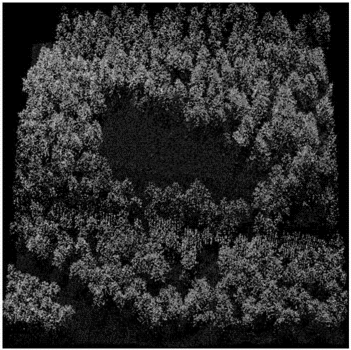
[0126] Plot situation:

[0127] The research area is located in Wugang Forest Farm (26°25′-27°00′N, 110°22′-113°3′E) in the southeast of Xuefeng Mountain, Hunan Province. The north is low, and the altitude is mostly 550-850m. This area has a mid-subtropical monsoon humid climate, with abundant rainfall, an average annual temperature of 16°C, an average annual precipitation of 1400mm, and an annual frost-free period of 250 days. The soil is mainly mountainous red soil and yellow brown soil. The main vegetation types are warm coniferous forest, evergreen broad-leaved forest, mixed coniferous and broad-leaved forest and deciduous broad-leaved forest. The field gap survey adopts the hemispherical image method, and the area of ​​the gap is determined according to the projection principle of the fisheye lens; the height of the boundary trees of the gap is measured by the angle gauge method or a telescopic altimeter; the altitude and position of the gap center are measured by DGPS or...


PUM


Abstract

The invention discloses a method for measuring a canopy gap three-dimensional structure based on laser radar. The method includes a first step of obtaining and pre-treating laser radar data which is remote sensing data obtained by laser radar loaded on a fixed wing aircraft or an unmanned aerial vehicle, the data of each laser point including X, Y, Z coordinate data and echo intensity data, a second step of processing canopy layer data, a third step of identifying canopy gaps, and a fourth step of measuring a three-dimensional canopy gap structure. The method is easy to realize, and is not affected by surveyed land and forest types and ground situations. Rapid, accurate, large-scale and multi-dimensional canopy structure measurement can be realized.

Description

technical field [0001] The invention relates to a method for measuring the three-dimensional structure of forest gaps based on laser radar. Background technique [0002] Canopy gap refers to the discontinuous forest gap formed in the forest canopy by human disturbance (selective felling) or natural disturbance (gale, snow, flood, debris flow, insect pests, etc.) in the main forest layer in the forest community. An important space for forest vegetation regeneration. As one of the important contents of forest ecology, forest gap research has important theoretical and practical significance. [0003] The measurement of the three-dimensional structure of the gap is the basis of the research on the gap. The three-dimensional structure of the gap mainly includes the area of ​​the gap, the shape of the gap and the height of the edge of the gap. At present, forest gap measurement methods can be divided into two categories: one is the direct method based on field measurement, and t...

Claims


Application Information

Patent Timeline
Patent Type & Authority Applications(China)
IPC IPC(8): G01S17/89
CPCG01S17/89
Inventor 刘峰杨志高
Owner CENTRAL SOUTH UNIVERSITY OF FORESTRY AND TECHNOLOGY
Why Eureka
Try Eureka