
Three-dimensional green quantity measuring and calculating method based on remote sensing image of unmanned aerial vehicle

A technology of three-dimensional green volume and remote sensing images, which is applied in computing, image analysis, image data processing, etc., can solve the time-consuming and labor-intensive problems of field surveys, achieve low cost, reduce time-consuming field work, and improve work efficiency.

Inactive Publication Date: 2018-01-23
辽宁远天城市规划有限公司 +1
View PDF4 Cites 3 Cited by
  • Summary
  • Abstract
  • Description
  • Claims
  • Application Information

AI Technical Summary

Problems solved by technology

[0006] In order to solve the unavoidable problems such as time-consuming and labor-intensive field surveys in the process of 3D green quantity measurement and calculation, and improve work efficiency, the purpose of the present invention is to provide a 3D green quantity measurement method based on UAV remote sensing images, which overcomes the existing methods. However, this method can quickly and accurately obtain the three-dimensional green quantity of the research area, and improve the benefits of the urban ecological environment.

Method used


Image

  • Three-dimensional green quantity measuring and calculating method based on remote sensing image of unmanned aerial vehicle
  • Three-dimensional green quantity measuring and calculating method based on remote sensing image of unmanned aerial vehicle
  • Three-dimensional green quantity measuring and calculating method based on remote sensing image of unmanned aerial vehicle

Examples


Embodiment 1

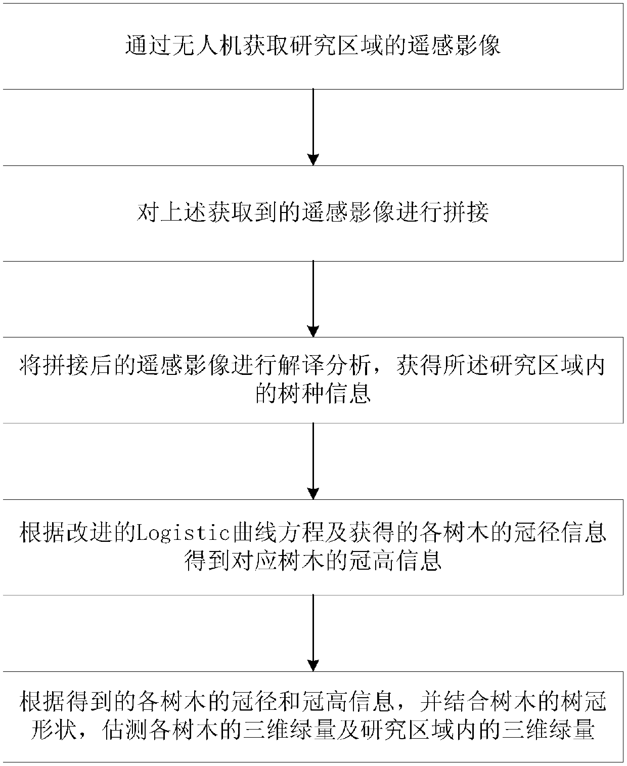
[0047] In the research area, use the typical sample selection method to select the research area, set up the experimental sample site, and use the fixed-wing or rotary-wing UAV to fly according to the pre-planned flight route. The ground station can check the flight route and status in real time. Obtain remote sensing images of the study area;

[0048] Import the UAV image into the stitching software, detect and match multiple features on the image, and automatically complete the geographicization and stitching. In order to better stitch the UAV image, the ground control point (GCP) is manually assigned in advance. In order to complete the research of a small number of evenly distributed coverage areas;

[0049] In order to improve the absolute spatial accuracy of the mosaic images, the differential global positioning system (DGPS) is used to analyze the GCP. In the selected GCP, the experimental points and inspection points are selected, and the Gauss-Kruger projection and th...


PUM


Abstract

The invention, which belongs to the application field of remote sensing of the unmanned aerial vehicle, discloses a three-dimensional green quantity measuring and calculating method based on remote sensing image of an unmanned aerial vehicle. A remote sensing image of an unmanned aerial vehicle is spliced and interpreted to obtain tree species information; on the basis of an improved Logistic curve equation and crown diameter information of all trees, crown height information of the trees is obtained; and then with combination of crown shapes of the trees, three-dimensional green quantities ofall trees and a three-dimensional green quantity in a studied region are obtained. The method has the high automation degree. With the method, problems of long satellite revisiting period and low timeliness in the prior art are solved; the three-dimensional green quantity of the studied region is obtained rapidly and precisely; and thus the ecological environmental benefits of the city are increased.

Description

technical field [0001] The invention belongs to the field of remote sensing applications of drones, and relates to a method for measuring and calculating three-dimensional green quantity based on remote sensing images of drones. Background technique [0002] With the continuous development of industry, the rapid rise of the economy, the continuous progress of society and the acceleration of urbanization, various environmental pollution problems such as water pollution, air pollution, urban garbage, and noise pollution have been brought along, making urban heat islands The impact of environmental pollution has been intensified, seriously destroying the living environment on which human beings depend for survival, affecting people's quality of life, and damaging human physical and mental health. These issues are receiving increasing attention as people's awareness of pollution issues continues to increase. Therefore, urban greening has become an important development trend of...

Claims


Application Information

Patent Timeline
Patent Type & Authority Applications(China)
IPC IPC(8): G06K9/00G06T7/60
Inventor 朱京海周雯慧刘合鑫问鼎刘冬烨
Owner 辽宁远天城市规划有限公司
Learn More