Automatic convergence imaging method based on ground penetrating radar echo data

A technology of echo data and ground penetrating radar, which is used in the reflection/re-radiation of radio waves, detection with electromagnetic waves, radio wave measurement systems, etc. problems such as slow speed, to achieve the effect of facilitating aggregation, reducing computing time, and meeting actual and application needs

Active Publication Date: 2018-08-10
XIAMEN UNIV
View PDF4 Cites 20 Cited by
  • Summary
  • Abstract
  • Description
  • Claims
  • Application Information

AI Technical Summary

Problems solved by technology

[0006] (1) The traditional bp algorithm needs to calculate the time delay of each radar at each pixel point, so the calculation amount is large and the calculation speed is slow;
[0007] (2) The sidelobe an...

Method used


Image

  • Automatic convergence imaging method based on ground penetrating radar echo data
  • Automatic convergence imaging method based on ground penetrating radar echo data
  • Automatic convergence imaging method based on ground penetrating radar echo data

Examples


Embodiment

[0053] Such as figure 1 As shown, an automatic convergence imaging method based on ground penetrating radar echo data, including:

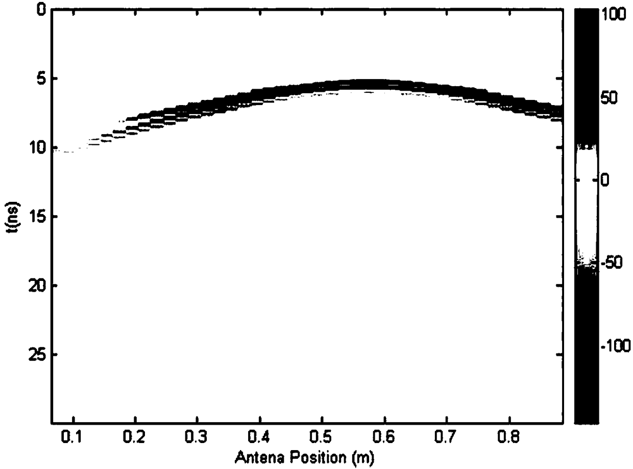
[0054] S1. Use the mean value to remove the background algorithm to filter the echo image and remove the surface clutter;

[0055] S2. Using a median filtering algorithm to remove echo image noise;

[0056] S3. Using threshold analysis to obtain the number of radars required by the pixel;

[0057] S4. Convergent imaging is performed on the echo images by using a back projection algorithm based on cosine distance weighting.

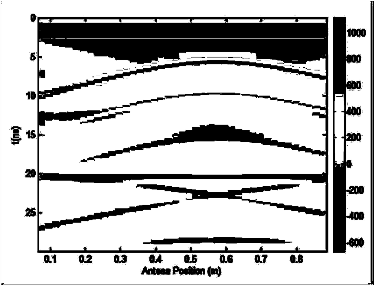
[0058] There are many clutters in the received signal of ground penetrating radar. Among them, the energy of the direct coupling wave of the antenna and the direct reflection wave of the medium surface is the largest, which is generally much larger than the target echo. Due to the existence of these two strong clutter signals, the compressed The dynamic range of the target echo reduces the system's ability to detect weakly re...


PUM


Abstract

The invention discloses an automatic convergence imaging method based on ground penetrating radar echo data. The method comprises the following steps: S1) carrying out filtering on an echo image through a mean de-background algorithm to remove ground clutters; S2) removing echo image noise through a median filtering algorithm; S3) obtaining the number of radars required by pixel points through threshold analysis; and S4) carrying out convergence imaging on the echo image through a back-projection algorithm based on cosine distance weighting. The method can quickly and automatically carry out convergence imaging on the ground penetrating radar echo image, and can still converge echo signals quickly and effectively under the complex urban environment by utilizing the back-projection algorithm based on cosine distance and threshold analysis image segmentation technology, thereby meeting practical and application requirements.

Description

technical field [0001] The invention relates to the field of radar imaging, in particular to an automatic convergence imaging method based on ground-penetrating radar echo data. Background technique [0002] As a transportation infrastructure, roads are of great significance to digital management and construction for applications such as urban planning, traffic management, and navigation. Roads are one of the most important infrastructures in my country's national economic construction, and their engineering quality is directly related to national property. losses and people's lives. In the process of road survey, design and construction, it is often encountered that there are various types of voids under the designed roadbed. The existence of unfavorable geological phenomena such as underground cavities often makes the subgrade unstable, causing damage to subgrades, road surfaces, bridges, culverts and other structures, which is extremely harmful to highway engineering and ...

Claims


Application Information

Patent Timeline
IPC IPC(8): G01S13/90G01V3/12
CPCG01S13/904G01V3/12
Inventor 李军洪志友罗志鹏邓振淼陈一平王程
Owner XIAMEN UNIV
Why Eureka
Try Eureka