Navigation method, device, apparatus, and storage medium based on ground texture image

A technology of texture image and navigation method, which is applied in the field of robotics and can solve problems such as low precision

Inactive Publication Date: 2019-04-02
BEIJING JIZHIJIA TECH CO LTD
View PDF5 Cites 30 Cited by
  • Summary
  • Abstract
  • Description
  • Claims
  • Application Information

AI Technical Summary

Problems solved by technology

[0004] Embodiments of the present invention provide a navigation method, device, device, and storage medium based on ground texture images to solve the technical problem of low precision when robots rely on image feature information for SLAM navigation in the prior art

Method used


Image

  • Navigation method, device, apparatus, and storage medium based on ground texture image
  • Navigation method, device, apparatus, and storage medium based on ground texture image
  • Navigation method, device, apparatus, and storage medium based on ground texture image

Examples


Embodiment 1

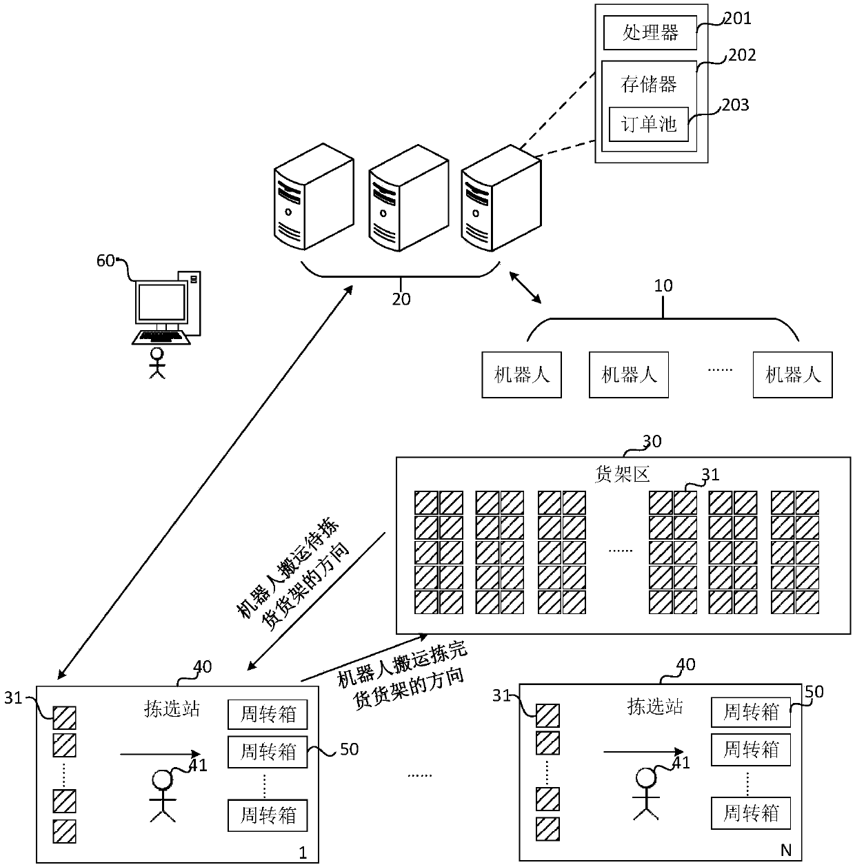
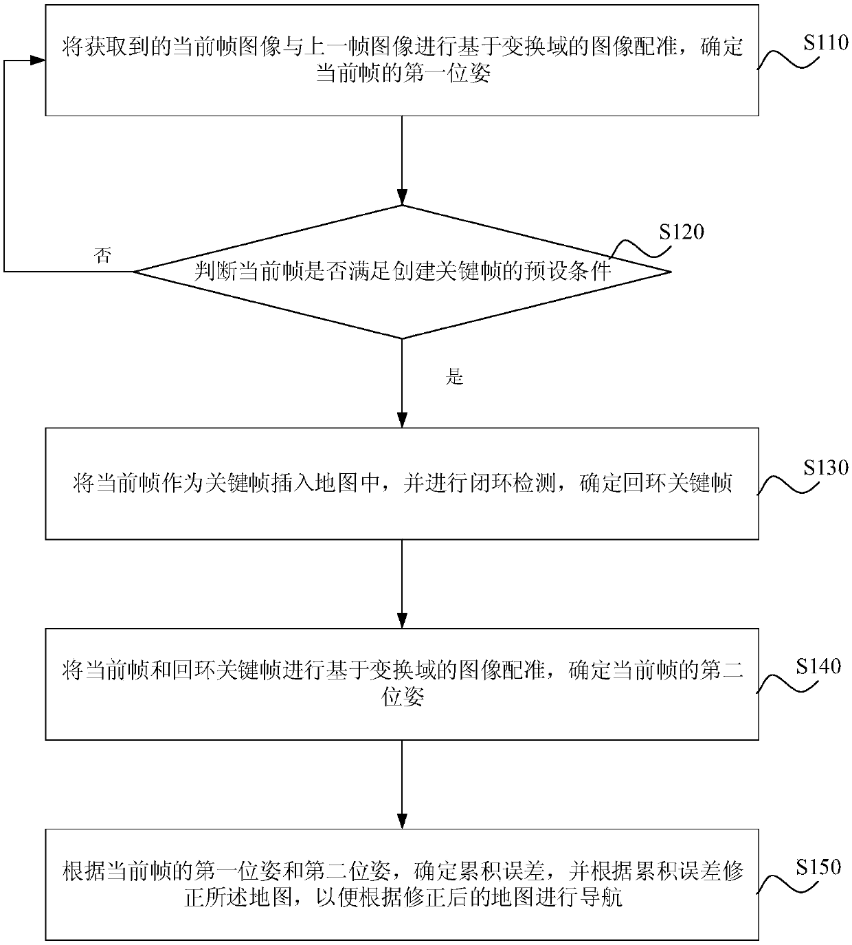
[0034] figure 2 It is a flow chart of the navigation method based on the ground texture image provided by Embodiment 1 of the present invention. This embodiment is applicable to the situation where the robot navigates based on SLAM (Simultaneous Localization And Mapping, real-time positioning and map construction). Texture image navigation device to implement, and can be integrated in electronic equipment, such as robots. Wherein, the navigation method based on the ground texture image mainly includes the following steps:

[0035] S110. Perform transform domain-based image registration on the acquired current frame image and the previous frame image, and determine a first pose of the current frame.

[0036] In the present invention, SLAM navigation based on ground texture features mainly includes tracking, composition, relocation and loop detection. Among them, the tracking link is real-time positioning, which mainly calculates the pose of the current frame image through th...

Embodiment 2

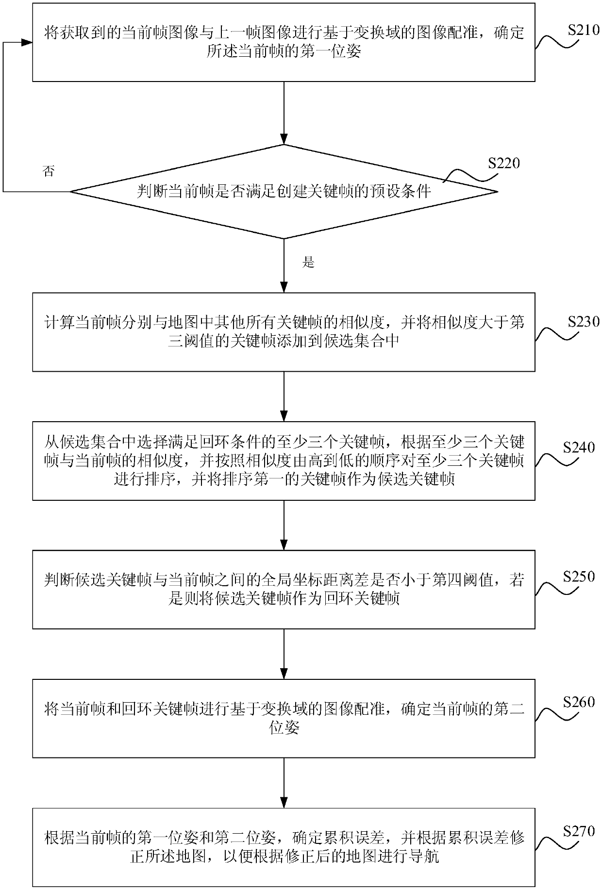
[0050] image 3 It is a schematic flow chart of the ground texture image-based navigation method provided by Embodiment 2 of the present invention. This embodiment is optimized on the basis of the foregoing embodiments, and the method includes:

[0051] S210. Perform transform domain-based image registration on the acquired current frame image and the previous frame image, and determine a first pose of the current frame.

[0052] S220. Determine whether the current frame satisfies the preset condition for creating a key frame, and if so, execute steps S230-S270. If not, continue to execute step S210.

[0053] S230. Calculate similarities between the current frame and all other keyframes in the map, and add keyframes with similarities greater than a third threshold to the candidate set.

[0054] In the present invention, when a new key frame is added to the map, loop closure detection is performed. First filter for keyframes that may be (forming) closed loops, where a close...

Embodiment 3

[0064] Figure 4 It is a schematic flowchart of the navigation method based on the ground texture image provided by the third embodiment of the present invention. This embodiment is optimized on the basis of the foregoing embodiments, and the method also includes:

[0065] S310. If the previous frame image is not a ground texture image, select a preset number of key frames to perform feature point matching with the current frame, and determine at least one candidate matching frame according to the matching results.

[0066] In the present invention, if there is an occlusion or a sudden movement, resulting in that the last frame image collected is not a ground texture image, that is, the feature is lost, global relocation is required. Exemplarily, by increasing the search range, a preset number of key frames can be selected to perform feature point matching with the current frame, and an alternative matching frame can be determined according to the matching result, that is, a ...


PUM


Abstract

Embodiments of the invention disclose a navigation method, a device, an apparatus, and a storage medium based on a ground texture image, wherein the method comprises the following steps: performing animage registration based on a transform domain on an acquired current frame image and a previous frame image to determine the first position of the current frame; determining whether the current frame satisfies a preset condition for creating a key frame, if yes, performing the following steps: inserting the current frame as the key frame into a map, and performing a closed loop detection to determine a loopback key frame; performing the image registration based on the transform domain on the current frame image and the loopback key frame to determine the second position of the current frame;determining a cumulative error according to the first position and the second position of the current frame, and modifying the map according to the cumulative error to navigate according to the modified map. According to the embodiments of the invention, the position can be calculated by the image registration based on the transform domain, the cumulative error is determined and modified, and theaccuracy of the SLAM navigation is improved.

Description

technical field [0001] The present invention relates to the technical field of robots, in particular to a navigation method, device, equipment and storage medium based on ground texture images. Background technique [0002] With the development of information technology and automatic control technology, robots have gradually entered people's daily life, can replace human work in complex environments, and have independent planning, self-organization, and self-adaptive capabilities, such as storage AGV robots based on SLAM navigation. The handling of goods is completed through SLAM navigation. [0003] In the prior art, the visual SLAM navigation of the robot mainly uses the ORB algorithm to detect feature points to realize simultaneous positioning and map construction. However, for images of complex scenes, the complexity of feature locations is high, and feature selection and extraction are difficult, making the accuracy of SLAM navigation relying on image feature informati...

Claims


Application Information

Patent Timeline
Patent Type & Authority Applications(China)
IPC IPC(8): G01C21/00G06T7/37
CPCG06T7/37G01C21/005G06T2207/20056G06T2207/10016G06T2207/30244G06T7/74G05D1/0246G05D1/0274G05D2201/0213G06T7/73G01C21/383G01C21/3837G05D2201/0216G06T1/0014G06T7/42
Inventor 王迎春纪彬
Owner BEIJING JIZHIJIA TECH CO LTD
Why Eureka
Try Eureka