A rapid slicing method and system for a multi-scale mass remote sensing image

A remote sensing image and multi-scale technology, applied in the field of visual processing, can solve problems such as publishing and visualization difficulties, and achieve the effects of improving user experience, enhancing throughput, and high availability

Pending Publication Date: 2019-06-25
湖北省基础地理信息中心(湖北省北斗卫星导航应用技术研究院)
View PDF2 Cites 9 Cited by
  • Summary
  • Abstract
  • Description
  • Claims
  • Application Information

AI Technical Summary

Problems solved by technology

[0004] Therefore, it is necessary to design a system that adapts to the massive growth trend of remote sensing data, meets the visualization of massive remote sensing data, and requires efficient and reliable storage and sharing for the proble

Method used


Image

  • A rapid slicing method and system for a multi-scale mass remote sensing image
  • A rapid slicing method and system for a multi-scale mass remote sensing image
  • A rapid slicing method and system for a multi-scale mass remote sensing image

Examples


Example Embodiment

[0032] The principles and features of the present invention will be described below with reference to the accompanying drawings. The examples cited are only used to explain the present invention, and are not used to limit the scope of the present invention.
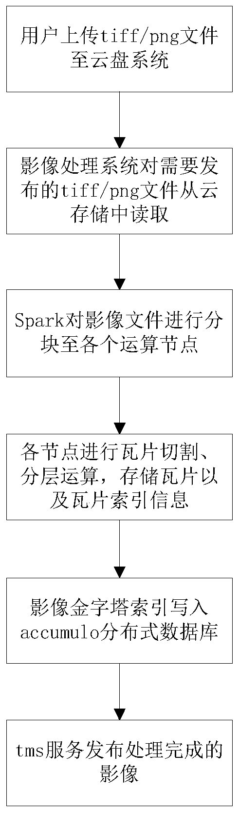
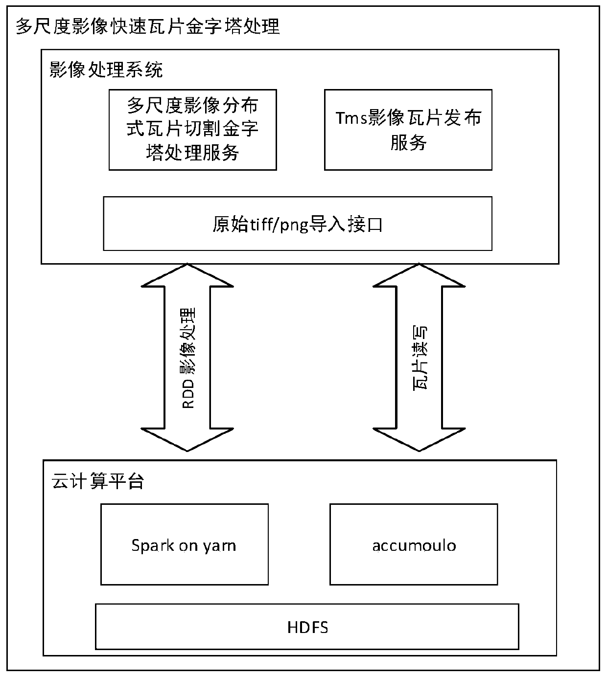
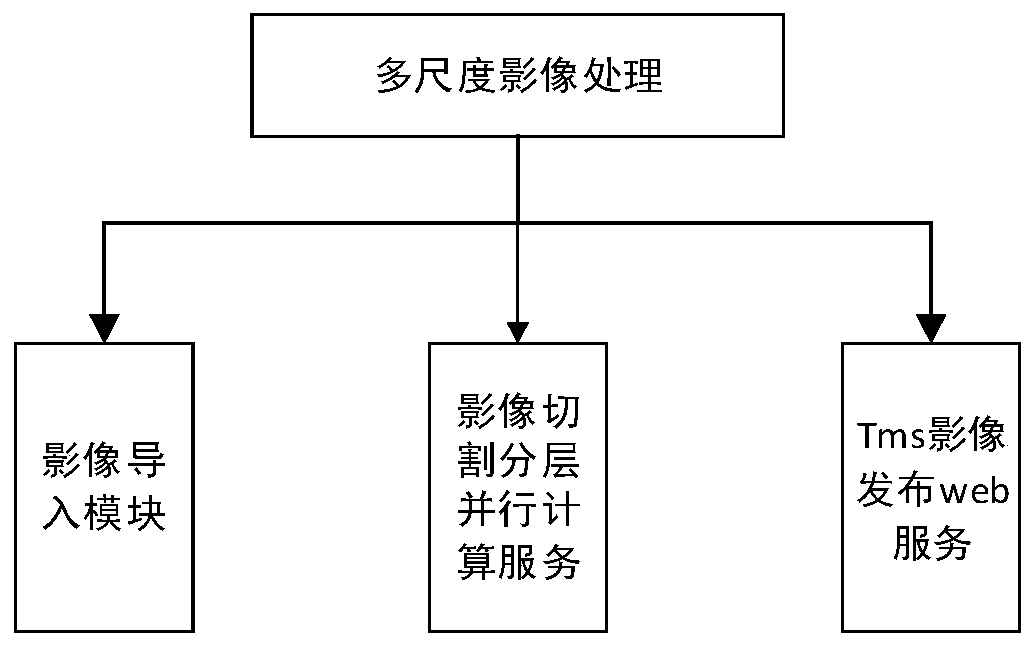
[0033] The present invention provides a fast slicing method for multi-scale massive remote sensing images, which includes the following steps:

[0034] S1 receives and stores image data files; by receiving image data files imported by users into the cloud storage system.

[0035] S2 performs block calculation of image data, performs image tile division and layering, which specifically include:

[0036] Read the corresponding image data file according to the image imported by the user into the cloud disk;

[0037] The image data is entered into the spark memory cloud computing platform for image tile segmentation and layering.

[0038] S3 builds a pyramid fast indexing system for image data based on the calculation results of S2. Bu...


PUM


Abstract

The invention discloses a rapid slicing method and system for a multi-scale mass remote sensing image. The method comprises the following steps: S1, receiving and storing an image data file; S2, carrying out task partitioning calculation on the image data, and carrying out tile segmentation and layering on the image data; And S3, constructing a pyramid rapid indexing system of the image data according to the calculation result in the step S2. According to the invention, the multi-scale image data is subjected to slicing, storage and service publication by establishing a rapid indexing mechanism; and rapid query and application of the image data are realized, so that the problems of time consumption, bottleneck in IO efficiency, unrecoverable program processing abnormity and inconvenience in service migration when the large image data is loaded from the disk in the traditional mode are solved, the data processing efficiency and throughput are enhanced, and the user experience and the actual application value of the image are improved.

Description

technical field [0001] The invention relates to visual processing, in particular to a fast slicing method and system for multi-scale massive remote sensing images. Background technique [0002] With the development of computer technology and network, geographic information system came into being, which caused a major change in GIS technology. The biggest advantage of GIS lies in the current situation of its spatial database, and with the development of GIS technology, the advantage of this feature becomes more prominent. Remote sensing images are one of the important data sources of geographic information systems, through which remote sensing images can quickly and continuously capture large-area, continuous and comprehensive geographic information. Space remote sensing technology can provide periodic observation results and provide more dynamic information for GIS. The remote sensing satellite data application industry supports my country's technological development and i...

Claims


Application Information

Patent Timeline
IPC IPC(8): G06F16/13G06F16/16
Inventor 段志强沈凤娇陈金文余晓敏余磊段红伟杜新黄冠宇陈晓茜
Owner 湖北省基础地理信息中心(湖北省北斗卫星导航应用技术研究院)
Why Eureka
Try Eureka