Optical system of color camera for digital aerial mapping

An optical system and color camera technology, applied in the field of optical imaging, can solve problems such as the complexity of the optical system, and achieve the effects of excellent imaging quality, reduced processing and manufacturing costs, and large imaging field of view

Pending Publication Date: 2019-07-12
FOSHAN UNIVERSITY
View PDF0 Cites 0 Cited by
  • Summary
  • Abstract
  • Description
  • Claims
  • Application Information

AI Technical Summary

Problems solved by technology

However, the optical system is relatively complicated, using as many as 12 optical lens elements; in order to correct aberrations, a triplet lens with relatively complicated processing and assembly technology is used.

Method used


Image

  • Optical system of color camera for digital aerial mapping
  • Optical system of color camera for digital aerial mapping
  • Optical system of color camera for digital aerial mapping

Examples


Embodiment 1

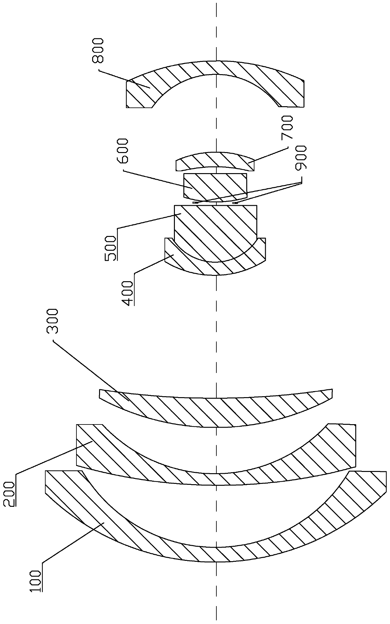
[0036] Embodiment 1, with reference to figure 1 , a digital aerial surveying and mapping color camera optical system, comprising: a front lens group, a middle lens group and a rear lens group;

[0037] The front lens group includes a first lens 100, a second lens 200 and a third lens 300;

[0038] The middle lens group includes a fourth lens 400, a fifth lens 500, a diaphragm 900, a sixth lens 600 and a seventh lens 700, and the diaphragm 900 is located between the fifth lens 500 and the sixth lens 600, The fourth lens 400 and the fifth lens 500 form a doublet lens;

[0039] The rear lens group includes an eighth lens 800;

[0040] The third lens 300, the fifth lens 500, the sixth lens 600 and the seventh lens 700 are all meniscus lenses and their refractive powers are all positive; the first lens 100, the second lens 200, and the fourth lens Both 400 and the eighth lens 800 are meniscus lenses with negative power;

[0041] The first lens 100, the second lens 200, the thir...


PUM


Abstract

The invention discloses an optical system of a color camera for digital aerial mapping. The optical system comprises a front lens group, a middle lens group and a rear lens group, wherein the front lens group comprises a first lens, a second lens and a third lens; the middle lens group comprises a fourth lens, a fifth lens, a diaphragm, a sixth lens and a seventh lens; the fourth lens and the fifth lens constitute a double-cemented lens; the rear lens group comprises an eighth lens; and the first lens, the second lens, the third lens, the fourth lens, the fifth lens, the diaphragm, the sixth lens, the seventh lens and the eighth lens are coaxially arranged in sequence along a light incidence direction. The optical system is simple in structure while having a large imaging field of view, high resolution and low distortion performance, uses a small number of lenses, reasonably distributes the power of each lens, and corrects the primary and high-order aberrations in a combination manner,so that the imaging quality is excellent, the manufacturing cost of the optical system is greatly reduced and light and small design is realized.

Description

technical field [0001] The invention relates to the technical field of optical imaging, in particular to an optical system of a digital aerial surveying and mapping color camera. Background technique [0002] Aerial surveying and mapping cameras are mounted on airborne platforms, capable of imaging ground objects at long distances, providing high-resolution, low-distortion remote sensing image information, and are widely used in fields such as agriculture and forestry, emergency disaster reduction, and urban planning and construction. Especially in recent years, with the introduction of concepts such as "smart city" and "digital city" and the rapid development of digital cities, aerial surveying and mapping cameras can provide high-definition surveying and mapping images with large area arrays and high-resolution images with accurate positions Information can play an important role in emergency response, urban security, urban functions and spatial layout, water conservancy p...

Claims


Application Information

Patent Timeline
IPC IPC(8): G02B13/00G02B13/06G02B27/00G02B1/00G01C11/02
CPCG02B13/006G02B13/06G02B1/00G02B27/0025G01C11/02
Inventor 伍雁雄谭海曙王茗祎
Owner FOSHAN UNIVERSITY
Why Eureka
Try Eureka