Semi-submersible unmanned vehicle submarine three-dimensional terrain detection device and method

A technology of unmanned aerial vehicles and three-dimensional terrain, which is applied in the direction of measuring devices, unmanned surface ships, radio wave measurement systems, etc. The effect of small terrain detection effect, good airworthiness and good stability

Pending Publication Date: 2019-09-06
HARBIN ENG UNIV
View PDF5 Cites 20 Cited by
  • Summary
  • Abstract
  • Description
  • Claims
  • Application Information

AI Technical Summary

Problems solved by technology

However, the traditional ship-borne multi-beam system has a relatively high cost of detection in the open sea, and requires detection personnel to monitor the whole process
The complex ocean environment will cause greater interference to surface ships, and surface ships need more complicated navigation routes to complete detection tasks, which will greatly reduce detection efficiency
[0003] Due to the high cost, poor accuracy, and low efficiency of traditional ship-borne multi-beam system seabed terrain detection and other methods, semi-submersible unmanned vehicle systems for marine terrain detection and inspection have become an important development trend in marine exploration.
The existing seabed terrain detection method of semi-submersible unmanned aerial vehicles has poor anti-interference ability to the environment. When the aircraft is navigating and working at sea, it will inevitably sway due to the disturbance of the ocean environment such as waves, sea wind and currents. Movement and violent shaking not only affect the navigation of the unmanned aerial vehicle, but also have a negative impact on the equipment on the hull, resulting in a relatively low accuracy of terrain detection
And because the speed of sound in the ocean changes with the temperature, salinity and pressure of the ocean environment, and the flow of the ocean, tides, currents, weather, waves, etc. will interfere with the positioning of the multi-beam transducer, thereby affecting the multi-beam transducer. Detection system for detection of seabed topography

Method used


Image

  • Semi-submersible unmanned vehicle submarine three-dimensional terrain detection device and method
  • Semi-submersible unmanned vehicle submarine three-dimensional terrain detection device and method
  • Semi-submersible unmanned vehicle submarine three-dimensional terrain detection device and method

Examples


Embodiment Construction

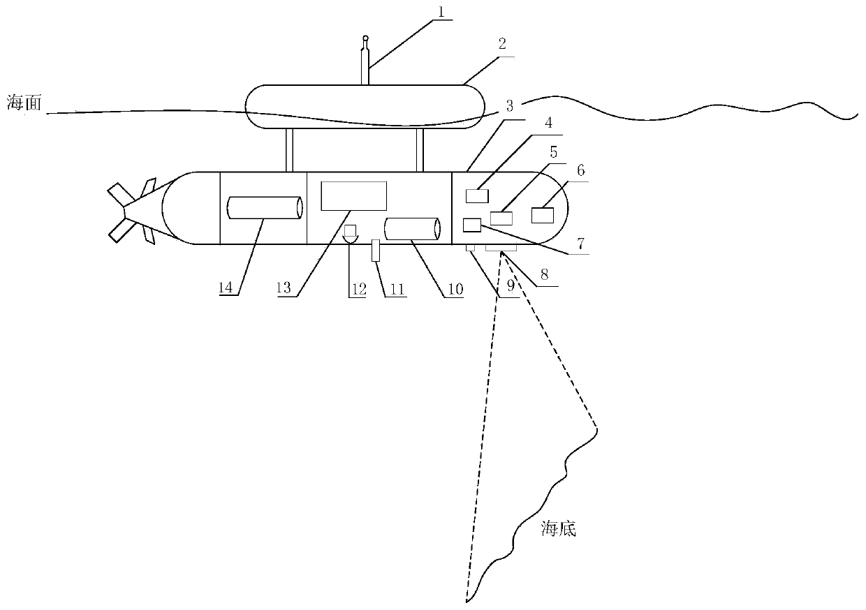
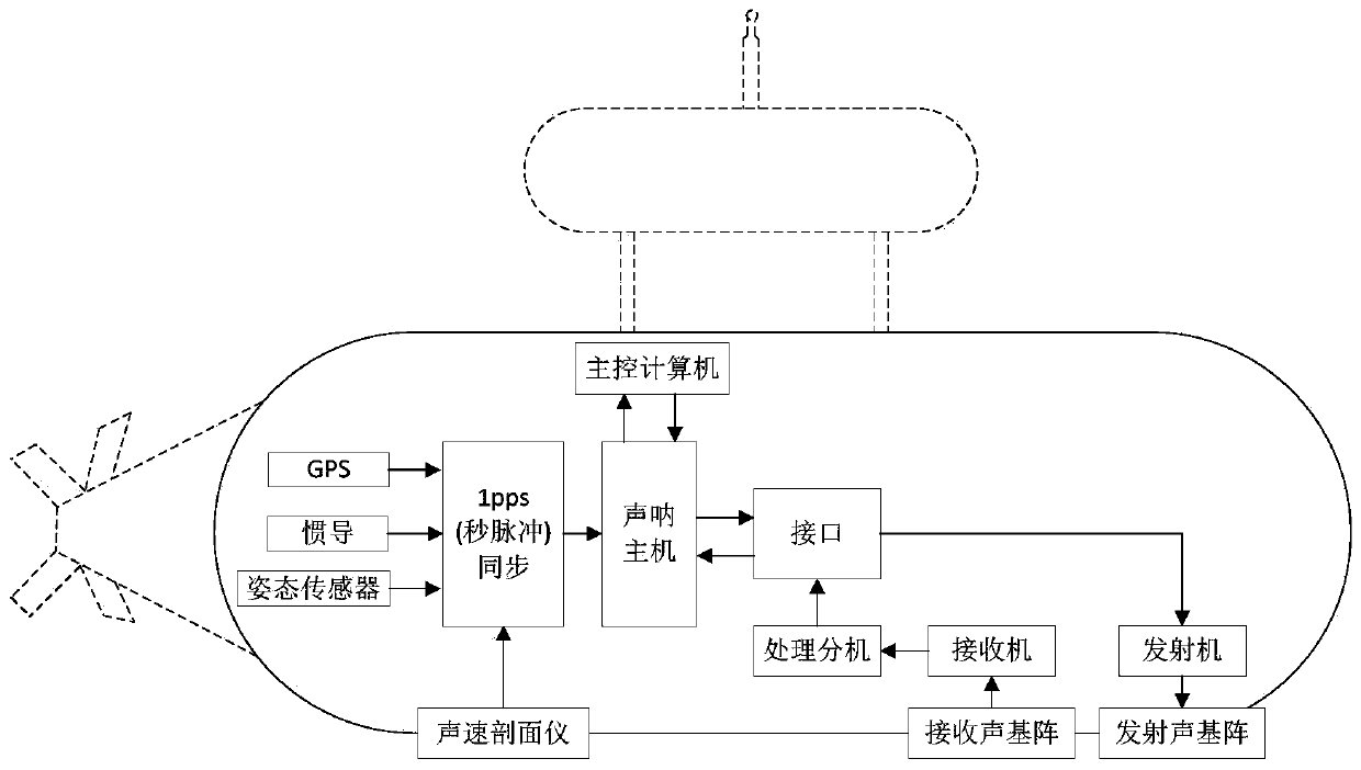
[0040] combine figure 1 , the semi-submerged unmanned vehicle seabed three-dimensional terrain detection device of the present invention is: the semi-submerged unmanned vehicle comprises a floating body 2 and a main hull 3, a GPS antenna 1 is arranged above the floating body, and a processing extension 4 is arranged on the main hull. Transmitter 5, attitude sensor 6, receiver 7, transmitting acoustic array 8, receiving acoustic array 9, sonar host 10, sound velocity profiler 11, inertial navigation system 12, main control computer 13 and lithium battery 14. Such as figure 2 As shown, the multi-beam sonar terrain detection system includes a processing extension 4 , a transmitter 5 , a receiver 7 , a transmitting acoustic array 8 , a receiving acoustic array 9 and a sonar host 10 .

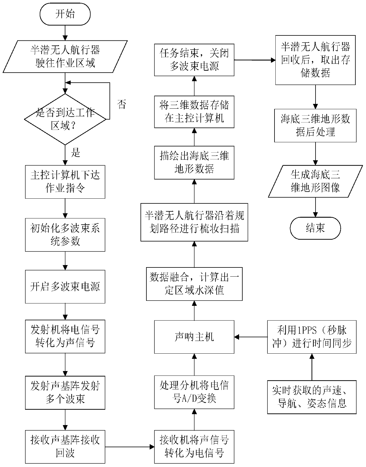
[0041] combine image 3 , the semi-submerged unmanned vehicle seabed three-dimensional terrain detection method of the present invention comprises the following steps:

[0042] Step 1: After the...


PUM


Abstract

The invention provides a semi-submersible unmanned vehicle submarine three-dimensional terrain detection device and method. The device comprises a semi-submersible unmanned vehicle composed of a floating body and a main hull, wherein an antenna is installed above the floating body, a multi-beam sonar terrain detection system, an attitude sensor, a sound velocity profiler, an inertial navigation system, a main control computer and a battery are installed on the main hull, and the multi-beam sonar terrain detection system comprises a processing extension, a transmitter, a receiver, a transmittedsound array, a received sound array and a sonar host. According to the device, task planning and scanning are performed through the semi-submersible unmanned vehicle carrying the multi-beam sonar terrain detection system, a water depth value is obtained through calculation according to back-and-forth time of sound waves, the angle of arrival of a beam and data obtained after time synchronous correction is performed by use of 1PPS, and a submarine three-dimensional terrain map is generated. The device has the advantages that a wave region is avoided, communication and positioning are not limited, the self-stability and invisibility are excellent, the measurement range is wide, measurement speed is high, and measurement efficiency is high.

Description

technical field [0001] The invention relates to a seabed topography measuring device. The invention also relates to a method for surveying seabed topography. Background technique [0002] At present, with the continuous development of marine resources in our country, there are more and more work items for survey and detection in the marine environment, and the requirements for underwater robots for marine scientific investigations are also getting higher and higher. The traditional 3D terrain detection method on the seabed is to use a surface ship equipped with a multi-beam system, a surface ship carrying a deep-water towing system (towfish) or a remote-controlled underwater robot (ROV) system using a dynamic positioning mother ship. Control the navigation detection route, and control the multi-beam system detection detection data in real time. However, the traditional ship-borne multi-beam system has a relatively high cost of detection in the open sea, and requires detect...

Claims


Application Information

Patent Timeline
Patent Type & Authority Applications(China)
IPC IPC(8): G01S15/89G01C21/20G01C21/16B63B35/00
CPCG01S15/89G01C21/203G01C21/165B63B35/00B63B2035/006
Inventor 盛明伟李俊唐松奇万磊秦洪德刘奕晖佟鑫
Owner HARBIN ENG UNIV
Why Eureka
Try Eureka