Digital terrain modeling method based on multi-source unmanned aerial vehicle remote sensing data fusion

A digital terrain and data fusion technology, applied in the field of UAV remote sensing in terrain surveying and mapping, can solve the problem of low elevation accuracy and achieve the effect of promoting the construction process, realizing sustainable development, improving surveying and mapping efficiency and modeling accuracy

Active Publication Date: 2019-09-10
HENAN UNIV OF SCI & TECH
View PDF5 Cites 11 Cited by
  • Summary
  • Abstract
  • Description
  • Claims
  • Application Information

AI Technical Summary

Problems solved by technology

However, obtaining DTM through aerial image processing technology or laser ranging technology has its own advantages and inherent defects: outputting DTM based on aerial image processing technology requires manual acquisition of a large number of three-dimensional coordinate values ​​(longitude, latitude and elevation) to ensure the overall accuracy of DTM, so this method is suitable for large-area surveying and mapping operations but does not require high elevation accuracy. Based on laser ranging technology, the spatial interpolation algorithm is used to expand point source elevation data into surfaces and then output DTM , it is necessary to comprehensively consider the measurement accuracy and distribution of point source elevation data, so this method is suitable for DTM surveying and mapping operations of small-area plots. Therefore, this invention proposes a digital terrain modeling based on the fusion of multi-source UAV remote sensing data method

Method used


Image

  • Digital terrain modeling method based on multi-source unmanned aerial vehicle remote sensing data fusion
  • Digital terrain modeling method based on multi-source unmanned aerial vehicle remote sensing data fusion
  • Digital terrain modeling method based on multi-source unmanned aerial vehicle remote sensing data fusion

Examples


Embodiment Construction

[0029] Specific examples are given below to further describe the technical solution of the present invention in a clear, complete and detailed manner. This embodiment is the best embodiment on the premise of the technical solution of the present invention, but the protection scope of the present invention is not limited to the following embodiments.

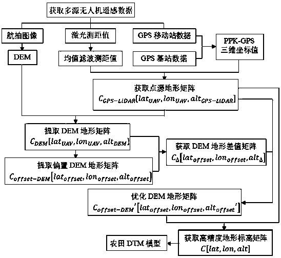
[0030] A digital terrain modeling method based on the fusion of multi-source UAV remote sensing data, combined with the data fusion technology of multi-source sensors such as UAV remote sensing image, laser rangefinder and GPS data, including the following steps, the flow chart is as follows figure 1 Shown:

[0031] Step 1. Vertically install the image acquisition equipment and laser rangefinder at the bottom of the UAV, and combine the technical requirements for aerial image stitching, image acquisition equipment parameters and the performance of the laser rangefinder to reasonably set the flight height and route of the UAV. Con...


PUM


Abstract

The invention discloses a digital terrain modeling method based on multi-source unmanned aerial vehicle remote sensing data fusion. The method comprises the steps of: acquiring aerial images, GPS data, laser range finder data and unmanned aerial vehicle micro electro mechanical system attitude data; obtaining post-processing dynamic GPS data; correcting the data of the laser range finder accordingto the attitude data of the micro-electromechanical system of the unmanned aerial vehicle; synchronous processing with post-processing dynamic GPS data is completed based on the time sequence; obtaining a laser ranging value and PPK-GPS three-dimensional coordinate value point source terrain matrix, an aerial image surface source digital elevation model and a digital elevation model terrain matrix; respectively carrying out offset, optimization and dimension raising processing on the digital elevation model terrain matrix, sequentially obtaining a digital elevation model difference matrix anda terrain elevation matrix, and carrying out Kriging spatial interpolation on the terrain elevation matrix to generate a digital terrain model; according to the method, the advantages of large surveying and mapping area of the surface source DTM and high absolute precision of the laser range finder and the GPS data point source DTM of the aerial image processing technology are combined, so that the surveying and mapping efficiency and the modeling precision are improved.

Description

technical field [0001] The invention relates to the application of UAV remote sensing in the field of terrain surveying and mapping, and more specifically, relates to a digital terrain modeling method based on fusion of multi-source UAV remote sensing data. Background technique [0002] According to the characteristics of terrain, area, and spatial structure, the precise leveling technology uses leveling machines to adjust measures to local conditions, which not only increases crop yield, but also greatly saves irrigation water, reduces the occurrence of diseases and insect pests, and inhibits the growth of weeds in the field. However, for a long time, the promotion and application of precision leveling technology in my country has not achieved significant results and comprehensive economic benefits. Most areas still use traditional leveling tools such as raking, rolling, and rolling that use their own gravity to passively adapt to terrain. The fundamental reason is that Beca...

Claims


Application Information

Patent Timeline
Patent Type & Authority Applications(China)
IPC IPC(8): G06T17/05
CPCG06T17/05
Inventor 杜蒙蒙姬江涛金鑫丁慧玲邱兆美庞靖王升升马淏赵龙
Owner HENAN UNIV OF SCI & TECH
Why Eureka
Try Eureka