A Method for Geological Hazard Analysis of Transmission Lines Based on Remote Sensing Data Fusion

A technology for geological disasters and transmission lines, applied in data processing applications, instruments, scene recognition, etc., can solve problems such as lack of active monitoring technology, and achieve the effect of ensuring safe operation, reducing economic losses, and reducing serious consequences

Active Publication Date: 2021-04-09
STATE GRID CORP OF CHINA +1
View PDF6 Cites 2 Cited by
  • Summary
  • Abstract
  • Description
  • Claims
  • Application Information

AI Technical Summary

Problems solved by technology

At present, the basic process of monitoring and controlling geological disasters in transmission line channels is the traditional group monitoring and group prevention method. Through daily line inspections or local residents inform the hidden dangers of tower channels or foundation slopes, and then take corresponding control measures to monitor power transmission. Geological disasters such as line tower landslides basically adopt some passive means such as video, rainfall collectors, displacement or deformation sensors, and lack an efficient and reliable active monitoring technology

Method used


Image

  • A Method for Geological Hazard Analysis of Transmission Lines Based on Remote Sensing Data Fusion
  • A Method for Geological Hazard Analysis of Transmission Lines Based on Remote Sensing Data Fusion
  • A Method for Geological Hazard Analysis of Transmission Lines Based on Remote Sensing Data Fusion

Examples


Embodiment Construction

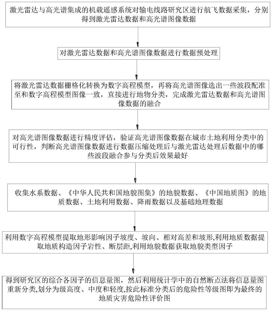
[0045] The following will clearly and completely describe the technical solutions in the embodiments of the present invention with reference to the accompanying drawings in the embodiments of the present invention. Obviously, the described embodiments are only some, not all, embodiments of the present invention. Based on the embodiments of the present invention, all other embodiments obtained by persons of ordinary skill in the art without making creative efforts belong to the protection scope of the present invention.

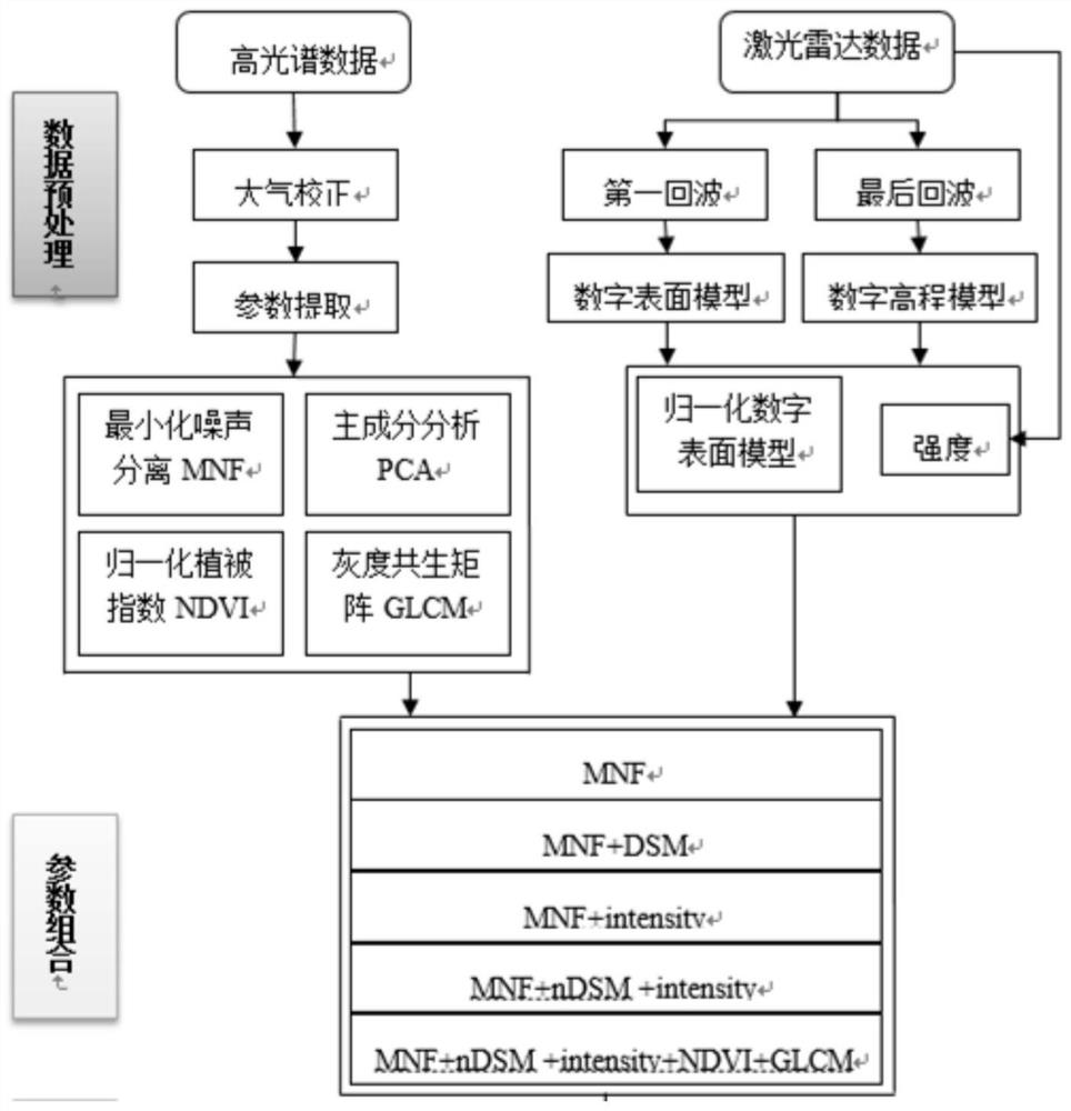
[0046] see figure 1 and figure 2 , the present invention provides a technical solution:

[0047] A method for analyzing geological hazards of transmission lines based on remote sensing data fusion, including the following specific steps:

[0048] Step 1. The airborne remote sensing system integrated with laser radar and hyperspectrum performs flight data collection on the transmission line research area, and obtains laser radar data and hyperspectral image ...


PUM


Abstract

The invention provides a method for analyzing geological hazards of power transmission lines based on remote sensing data fusion. The specific steps are: collecting flight data to obtain laser radar data and hyperspectral image data respectively; performing data pre-processing on the laser radar data and hyperspectral image data. Processing; complete the fusion of lidar data and hyperspectral image data; evaluate the accuracy of hyperspectral image data; collect water system data, landform data, geological data, land use data, rainfall data and basic geographic data; extract various types of factors; get Synthesize the information map of each factor in the study area, and then use the natural breakpoint method in statistics to reclassify the information map into high, moderate and light levels. The risk level map classified according to this standard is It is the final geological hazard risk assessment map. The advantages of combining the two remote sensing data provide effective technical support for the investigation of hidden dangers of geological hazards in transmission line channels.

Description

technical field [0001] The invention relates to the field of geological disaster analysis, in particular to a method for analyzing geological disasters of transmission lines based on fusion of remote sensing data. Background technique [0002] In recent years, due to changes in the natural environment and the impact of human activities, geological disasters such as landslides and debris flows in transmission line channels have occurred frequently, especially in the unstable geomorphic units of the Three Gorges Reservoir area. There are different potential geological hazards. Therefore, there are relatively high risks of geological disasters such as landslides and debris flows in the foundations of some transmission line towers in this area, especially the geological disasters on high slopes will directly harm the transmission tower itself. The Yichang Operation and Maintenance Branch of the State Grid Hubei Maintenance Company removed the hidden dangers of geological disast...

Claims


Application Information

Patent Timeline
Patent Type & Authority Patents(China)
IPC IPC(8): G06K9/00G06K9/62G06Q50/06G06Q50/26
CPCG06Q50/06G06Q50/26G06V20/194G06V20/13G06F18/24
Inventor 韩昊侯金华翁永春方权张学锋李小来杨晓东
Owner STATE GRID CORP OF CHINA
Why Eureka
Try Eureka