Ortho-image real-time generation method and system based on aerial photography data of unmanned aerial vehicle

A digital orthophoto and orthophoto technology, applied in radio wave measurement systems, satellite radio beacon positioning systems, image data processing, etc. Deal with issues such as unknown or inaccurate route planning information

Active Publication Date: 2020-01-03
武汉九州位讯科技有限公司
View PDF13 Cites 18 Cited by
  • Summary
  • Abstract
  • Description
  • Claims
  • Application Information

AI Technical Summary

Problems solved by technology

This method relies on a high-precision POS system (Positioning and Attitude Determination System), and does not clearly provide a calculation method for the local average elevation, and this method only uses the rotation matrix composed of the angular elements of the camera's external orientation elements to transform the oblique image into a horizontal image. The accuracy of the generated orthophoto is not high enough, and this method cannot finally generate models such as DEM and Mesh
In addition, this method calculates the size of the mosaic image according to the pre-divided aerial photography area information and the scale of the panoramic image. It is difficult to cope with unknown or inaccurate route planning information; generally, the image size of the panoramic image can only be estimated roughly or saturated, but the image size of the panoramic image cannot be accurately calculated; when generating a panoramic image The processing of the graph takes up a lot of memory resources
However, the problem with this method is that it relies on a high-precision POS system, or requires known high-precision POS data; it is suitable for the generation of large-scale orthophotos with low precision (meter level), such as using large-scale digital aerial photography Or satellite imagery to generate meter-level precision DOM, also can not generate Mesh model and higher precision DEM data

Method used


Image

  • Ortho-image real-time generation method and system based on aerial photography data of unmanned aerial vehicle
  • Ortho-image real-time generation method and system based on aerial photography data of unmanned aerial vehicle
  • Ortho-image real-time generation method and system based on aerial photography data of unmanned aerial vehicle

Examples


Embodiment

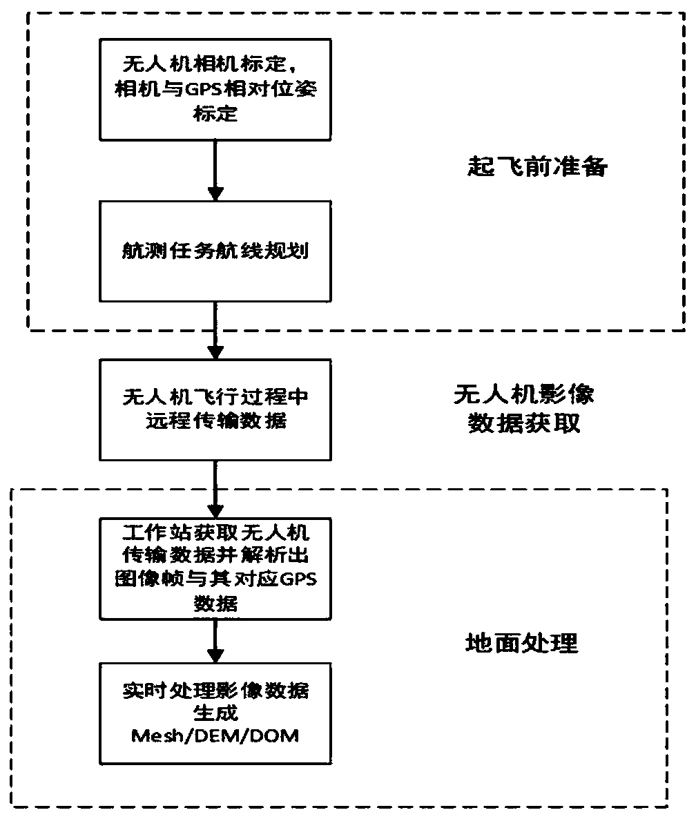
[0080] This embodiment will provide a preferred implementation of the method for real-time generation of orthophotos based on UAV aerial photography data. The process of this preferred implementation can be found in figure 1 , mainly including the preparation work before the UAV takes off, the transmission of the image data during the flight of the UAV, and the processing of the received image data on the ground. The specific implementation manners of these three major parts will be described in detail below.

[0081] Step 100, preparations before the drone takes off.

[0082] The preparatory work further includes ①UAV camera calibration, and ②according to the actual situation of the aerial survey area, the requirements for image resolution, UAV heading, and lateral overlap, route planning and aerial survey task setting. Camera calibration is used to obtain camera calibration parameters, which include radial distortion parameters k 1 、k 2 、k 3 , eccentricity distortion par...


PUM


Abstract

The invention discloses an ortho-image real-time generation method and system based on aerial photography data of an unmanned aerial vehicle, and the method can achieve the following processing of a single-frame image in a single-frame image sequence obtained through the decomposition of video stream data collected by the unmanned aerial vehicle, and comprises the steps: (1) removing the camera distortion of the single-frame image, and extracting a feature point; (2) constructing a global map based on the single-frame image sequence; and (3) finding a newly generated triangular patch in a mappoint triangulation network constructed by the global map point cloud, finding a corresponding key frame texture for the newly generated triangular patch, and carrying out texture mapping to finally obtain a digital orthoimage. In the process, a digital surface model and a digital elevation model can be generated by using global map point cloud. Real-time generation of a high-precision orthographic image product can be achieved without depending on a high-precision positioning and attitude determination system, aerial photography data processing can be synchronously completed in the flight process of the unmanned aerial vehicle, and the requirements for real-time performance and high precision can be met.

Description

technical field [0001] The invention relates to the field of UAV photogrammetry, in particular to a method and system for real-time generation of orthophoto images based on UAV aerial photography data. Background technique [0002] In recent years, drones have been widely used in surveying and mapping, exploration, emergency response, disaster relief and other fields due to their high efficiency, flexibility, and low cost. UAV aerial photogrammetry technology greatly reduces the cost of traditional aerial photogrammetry technology, making aerial photogrammetry technology from aristocratic to civilian, and has more general practical significance and application value. [0003] But on the other hand, the traditional implementation method of UAV image processing is to transmit the UAV aerial image to a computer or server through the USB interface for post-processing after the aerial photography mission is completed. Generally, it is necessary to collect ground control points an...

Claims


Application Information

Patent Timeline
Patent Type & Authority Applications(China)
IPC IPC(8): G06T17/05G06T17/20G06T15/04G06T5/00G06T7/80G01S19/25
CPCG01S19/252G06T5/006G06T7/80G06T15/04G06T17/05G06T17/20
Inventor 肖雄武季博文
Owner 武汉九州位讯科技有限公司
Why Eureka
Try Eureka