Watershed water quality monitoring abnormal value detection method based on spatial relationship

A water quality monitoring and spatial relationship technology, which is applied in general water supply saving, complex mathematical operations, instruments, etc., can solve the problems of low accuracy of water quality abnormal value detection and neglect of water quality abnormal value characteristics, so as to improve the detection rate and accuracy rate Effect

Active Publication Date: 2020-01-31
INST OF GEOGRAPHICAL SCI & NATURAL RESOURCE RES CAS
View PDF7 Cites 10 Cited by
  • Summary
  • Abstract
  • Description
  • Claims
  • Application Information

AI Technical Summary

Problems solved by technology

[0007] All the detection methods mentioned above have a common feature, that is, they are all general detection methods for outliers, but they are only applied t

Method used


Image

  • Watershed water quality monitoring abnormal value detection method based on spatial relationship
  • Watershed water quality monitoring abnormal value detection method based on spatial relationship
  • Watershed water quality monitoring abnormal value detection method based on spatial relationship

Examples


Embodiment Construction

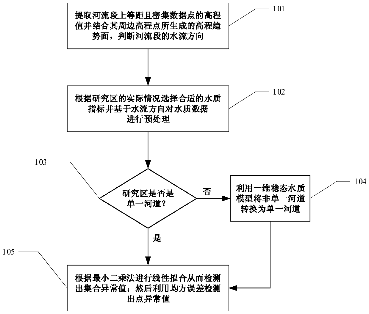
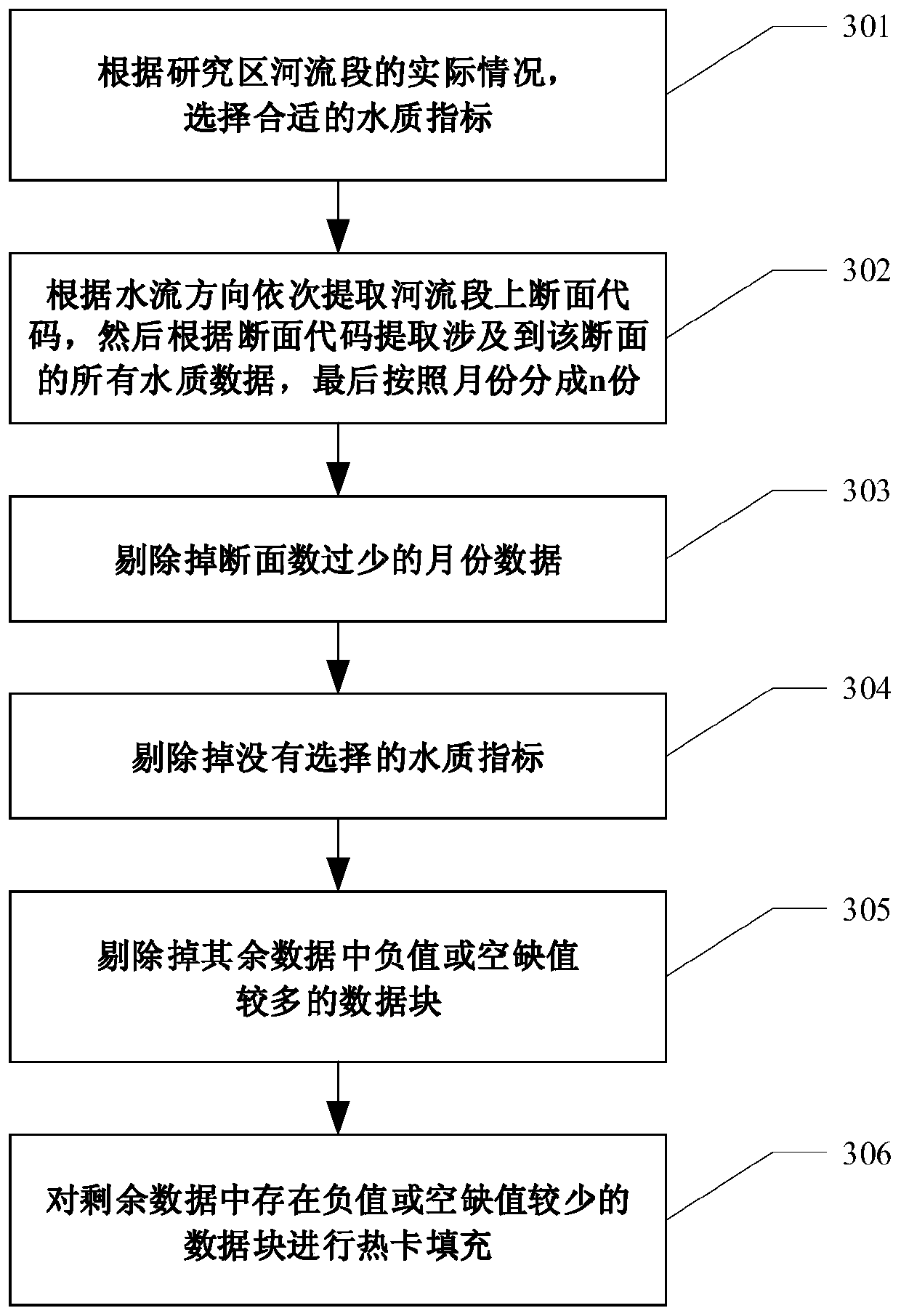
[0051] In conjunction with the water quality outlier detection method in the present invention, provide the following embodiments: for the vector data and water quality index data of a certain specific river section and its upper section in the Yellow River Basin, by selecting suitable water quality indexes and combining the method in the present invention Detect outliers in water quality data.

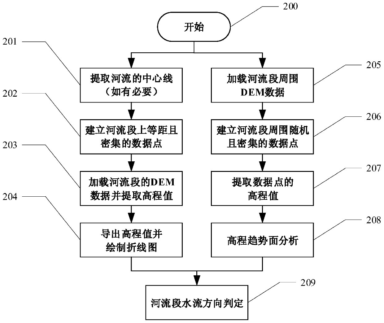
[0052] For a given river section in the Yellow River Basin, the technical flow chart of a method for detecting outliers in water quality monitoring based on spatial relationships proposed by the present invention is as attached figure 1 shown, including the following steps:

[0053] Step 101: For the vector data of a given river segment, generate equidistant and dense data points on the river segment, and then extract the elevation value of the data point; generate random and dense data points around the river segment and extract the Elevation values, followed by trend surface analys...


PUM


Abstract

The invention relates to a watershed water quality monitoring abnormal value detection method based on a spatial relationship. The method comprises detecting abnormal values of a single river channeland a non-single river channel, and is suitable for detecting point abnormality and set abnormal values in water quality monitoring data. For the single river channel, equidistant and dense data points are generated on a river section, and the flow direction of the river is judged by extracting the elevation values of the equidistant and dense points and combining the terrain around the equidistant and dense points; linear simulation is carried out on the data of the same water quality index in the same month by utilizing a least square method, and a set abnormal value is separated according to the slope of a simulation straight line; and a mean square error is calculated and a corresponding threshold value is set, and point anomaly judgment is carried out on the remaining data. For the non-single river channel, the water quality index values of the main stream and the branch stream are calculated at the intersection of the main stream and the branch stream by utilizing a one-dimensional water quality model, and the abnormal value detection of the non-single river channel is converted into the abnormal value detection of the single river channel through comparison. According to themethod, water quality abnormal value detection is carried out by utilizing the relationship among the spatial position of the water quality section, the terrain and the water system, so that point abnormality and set abnormality are separated, and the abnormal value detection accuracy is improved.

Description

technical field [0001] The invention belongs to the information field where geographic information systems intersect with hydrology and water resources, and in particular relates to a method for detecting abnormal values ​​of river basin water quality monitoring based on spatial relationships. Background technique [0002] With the rapid growth of world population and the continuous development of social economy, serious water pollution problems also appear. In recent years, the relevant departments of the country have built a large number of water quality monitoring stations in major rivers, lakes, reservoirs, etc. to monitor the water quality of each section at regular intervals, thus obtaining a large amount of water quality monitoring data. However, in the process of processing it, outliers will greatly interfere with the analysis results of water quality data, so how to effectively identify outliers in water quality data has become a major and difficult problem to be so...

Claims


Application Information

Patent Timeline
IPC IPC(8): G06F17/18G06Q10/06
CPCG06F17/18G06Q10/06393Y02A20/152
Inventor 高锡章翟德超李宝林袁烨城
Owner INST OF GEOGRAPHICAL SCI & NATURAL RESOURCE RES CAS
Why Eureka
Try Eureka