Eureka AIR delivers breakthrough ideas for toughest innovation challenges, trusted by R&D personnel around the world.

River hydrological landform change key factor contribution degree analysis method and system

A technology of key factors and contribution degrees, which is applied in the analysis method and system field of key factors of river hydrology and landform changes, can solve the problems of increasing the difficulty of understanding, the inability to give the influence value and contribution degree of key factors, and the lack of systematic research methods, etc.

Active Publication Date: 2020-05-01
TIANJIN RES INST FOR WATER TRANSPORT ENG M O T
View PDF4 Cites 1 Cited by
  • Summary
  • Abstract
  • Description
  • Claims
  • Application Information

AI Technical Summary

Problems solved by technology

For alluvial rivers, there are many factors that affect the change of river hydrology and geomorphology such as river bed topography and dry water level, but it is generally believed that changes in river water and sediment conditions, sand mining activities, and river channel improvement projects are the key factors. Since these factors are often superimposed on each other, Increased the difficulty of understanding. Due to the lack of systematic research methods, the existing research on riverbed deformation and dry water level changes is mainly based on qualitative analysis, and the influence value and contribution of key factors cannot be given, which is not conducive to a deep understanding of the dynamics of river topography and hydrological changes. and law

Method used


Image

  • River hydrological landform change key factor contribution degree analysis method and system
  • River hydrological landform change key factor contribution degree analysis method and system
  • River hydrological landform change key factor contribution degree analysis method and system

Examples


Embodiment application example 1

[0122] In recent years, the Wuzhou section of the Xijiang River has undergone new changes in the hydrological environment characterized by a sharp decrease in sand, a sharp incision of the riverbed, and a significant drop in the dry water level. In the early stages of the operation of the first-line and second-line ship locks of the Changzhou Hub, serious ship jams and delays have occurred. aroused widespread social concern. At present, due to the lack of systematic research methods, the existing research on riverbed deformation and dry water level changes is mostly based on qualitative analysis, and the influence value and contribution of each factor cannot be given.

[0123] For quantitatively researching the influence of each factor and verifying the effect of the present invention, for the most obvious change in the dry water level of the Wuzhou River section

[0124] From 2003 to 2014, two surveyed topographic maps of the Xijiang River from Jieshou to Zhaoqing in 2004 and...

Embodiment application example 2

[0137] After the water storage of the Three Gorges Project in 2003, due to water storage and sediment retention, the flow of dry water in the middle reaches of the Yangtze River increased, and the riverbed continued to scour for a long distance. In order to study the changes in the hydrological environment before and after the water storage of the Three Gorges Project, the minimum navigable water level of the channel design ( Guaranteed rate of 98% water level), it is necessary to grasp the influence of flow change factors and riverbed deformation factors on the design minimum navigable water level (guaranteed rate of 98% water level). Since the main factor affecting the riverbed deformation in the middle reaches of the Yangtze River is the natural scouring and silting effect of the water flow on the riverbed, the influence of sand mining in the river channel is not considered, and there is no need to analyze the changes in the amount of scouring and silting of the riverbed caus...


PUM


Abstract

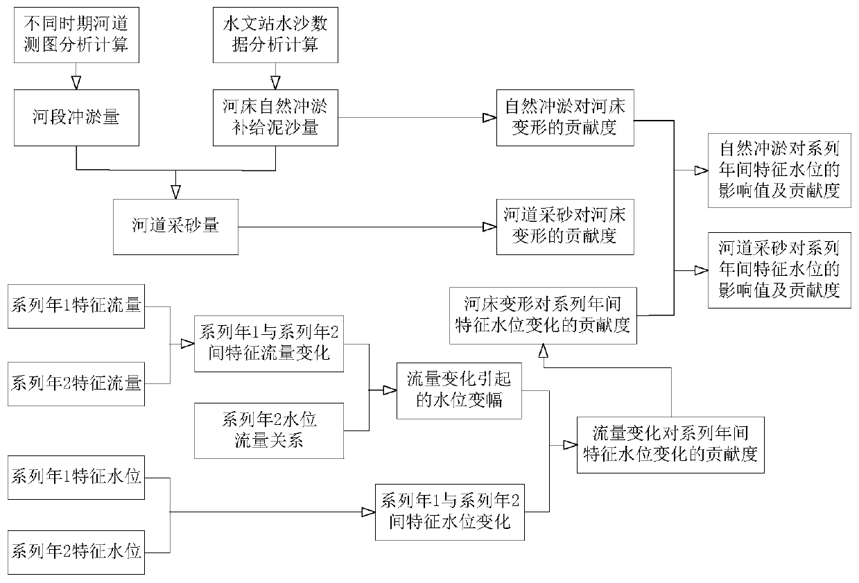
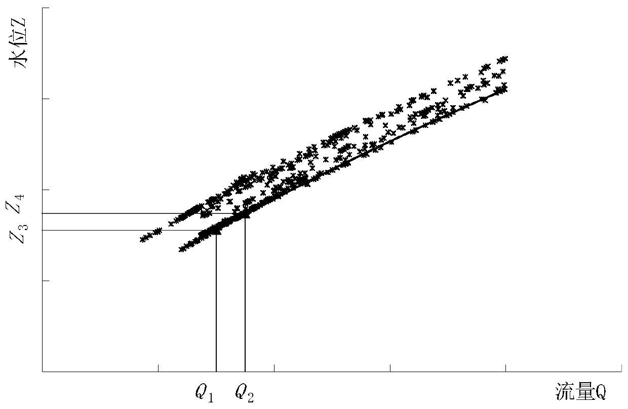
The invention discloses a river hydrological landform change key factor contribution degree analysis method and system, and the method comprises the steps: determining the total riverbed erosion and deposition amount delta S of a research reach according to the river topographic data obtained through two times of actual measurement; determining the input sediment amount Sq of the branch of the research river section and the natural erosion and deposition replenishment sediment amount S1 of the main stream riverbed; S2, determining the contribution degree of each factor for driving the riverbeddeformation of the research reach, selecting the guarantee rate P of dry water level and flow analysis, and determining the influence value and the contribution degree of each factor for driving thedry water level to change. Based on a sediment total conservation principle, the research reach is used as a whole. River topography, hydrological sediment of an adjacent hydrological station, seriesannual characteristic flow of the hydrological station, characteristic water level change, water level flow relation and the like are measured in a research time period; the contribution degree of key factors such as flow, sand mining and natural silt washing for driving the dry water level change is determined, and a new scheme is provided for analyzing the contribution degree of the key factorsof river hydrological and geomorphic change.

Description

technical field [0001] The invention belongs to the field of waterways and water conservancy projects, and in particular relates to a method and system for analyzing the contribution degree of key factors in river hydrology and landform changes. Background technique [0002] With the impact of the operation of cascade reservoirs, the implementation of water and soil conservation projects, and sand mining in rivers, rivers in my country have generally experienced new changes in river hydrology and landforms in recent years, characterized by a sharp decrease in sand, a sharp incision of the river bed, and a significant drop in dry water levels. The incision of the river bed and the drop of the dry water level are related to the safety of river water ecology and navigation, especially in the downstream reaches of the final hub of some rivers, which are significantly affected by the change of river water and sediment but have weak regulation and storage capacity, such as the Shui...

Claims


Application Information

Patent Timeline
IPC IPC(8): G06F16/29G06F17/11
CPCG06F16/29G06F17/11
Inventor 张明冯小香普晓刚刘哲闫涛章日红
Owner TIANJIN RES INST FOR WATER TRANSPORT ENG M O T
Why Eureka
Eureka Blog
Learn More