DSM generation method based on video satellite image

A video image and satellite image technology, applied in the field of satellite remote sensing image processing, can solve the problems of difficult field data collection and single data type

Active Publication Date: 2020-05-08
CHANGGUANG SATELLITE TECH CO LTD
View PDF3 Cites 9 Cited by
  • Summary
  • Abstract
  • Description
  • Claims
  • Application Information

AI Technical Summary

Problems solved by technology

[0007] The present invention provides a DSM generation method based on video satellite images to solve the problems of the existing DSM generatio

Method used


Image

  • DSM generation method based on video satellite image
  • DSM generation method based on video satellite image
  • DSM generation method based on video satellite image

Examples


specific Embodiment approach 1

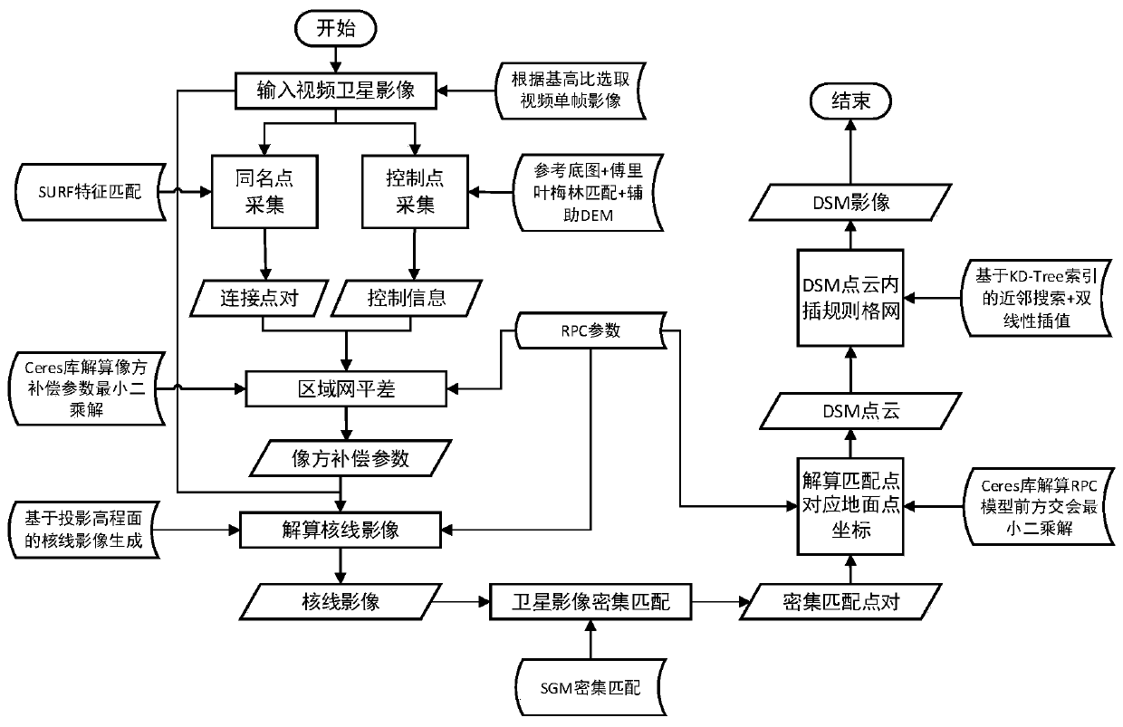
[0068] Specific implementation mode 1. Combination Figure 1 to Figure 7 Describe this embodiment, a DSM generation method based on video satellite images, to generate DSM image products for video satellite images, the process includes image input, control point collection, homonym point collection, block adjustment, epipolar line image generation, Dense matching, elevation calculation, DSM point cloud interpolation regular grid. After processing, the DSM image generated based on the video satellite image is obtained. The specific implementation process is:

[0069] 1. Input satellite video images, the satellite video images are staring images;

[0070] With the movement of the satellite, a video is staring at a certain shooting area. In the video image sequence, the middle frame image Img_mid is selected as the main image. According to the requirements of the base height ratio of photogrammetry, the base height ratio is selected A frame of image Img_fz is used as a search ...

specific Embodiment approach 2

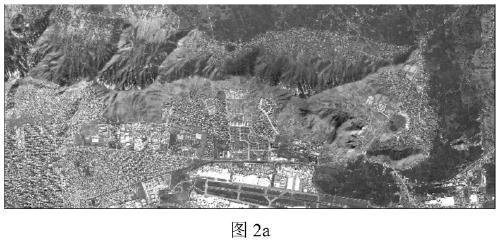
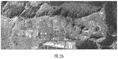
[0145] Specific embodiment two, combine Figure 2 to Figure 7 Describe this embodiment. This embodiment is a verification example of the DSM generation method based on video satellite images described in Embodiment 1: the intermediate results obtained in each step of the video image generation DSM process are given in sequence, and finally shown Generated DSM results.

[0146] Such as figure 2 The image shown is the image of Kabul, the capital of Afghanistan, taken by the Jilin-1 video 03 video star data, with a high degree of overlap; image 3 The reference basemap for downloading is a high-definition image from Google Earth, which can cover figure 2 the extent of the image in the Figure 4 The generated epipolar image based on the projected elevation surface, after resampling, the epipolar image has a visual effect of rotation; Figure 5 It is a detailed map of the row correspondence of epipolar image pairs. It can be seen that the same ground object is in the same row...


PUM


Abstract

The invention discloses a DSM generation method based on a video satellite image, and relates to the technical field of satellite remote sensing image processing, which can solve the problems that anexisting DSM generation method is difficult in on-site data acquisition area, too single in data type, needs to execute multiple shooting tasks and the like. Control point extraction is suitable for reference base map extraction control information with large time phase difference through a Fourier Merlin algorithm. In the epipolar line generation link, a method based on a projection elevation plane is used, a high-precision epipolar line image can be obtained, densely matched search is accurately reduced to a one-dimensional search line from a two-dimensional image plane, and the working efficiency is improved; an SGM matching method is adopted in the dense matching environment, dynamic planning is conducted through an energy function, and a parallax relation graph with the best continuity and integrity is obtained. According to the invention, high-precision DSM image result rapid generation is realized through control point acquisition, homonymous point acquisition, block adjustment,epipolar line image generation, dense matching, DSM point cloud generation and regular grid interpolation operation.

Description

technical field [0001] The invention relates to the technical field of satellite remote sensing image processing, in particular to a method for generating a DSM based on satellite images. Background technique [0002] The "Jilin No. 1" series of video satellites independently developed by Changguang Satellite Technology Co., Ltd. has a meter-level spatial resolution and a video image size of 12k×5k. Therefore, it can obtain more detailed features of ground objects in a large field of view, which is more conducive to the elevation calculation and 3D reconstruction of the ground. To sum up, in order to obtain a high-precision digital surface model (DSM) by using the multi-angle ground object information of the Jilin-1 video satellite in the gaze mode, it is necessary to study a DSM generation method based on video satellite images. [0003] At present, there is no method in the industry to use satellite dynamic video images to generate DSM. In the traditional DSM generation w...

Claims


Application Information

Patent Timeline
IPC IPC(8): G06K9/00G06K9/46G06K9/62G06T3/00G06T3/40
CPCG06T3/0006G06T3/4023G06T2207/10032G06V20/13G06V10/462G06F18/22
Inventor 李文涛张鹏杨浩朱瑞飞高放
Owner CHANGGUANG SATELLITE TECH CO LTD
Why Eureka
Try Eureka