Meteorological satellite dynamic tropospheric top height inversion method and device, storage medium and computer equipment

A dynamic convection and height inversion technology, applied in the field of meteorological remote sensing, which can solve the problems of low spatial and temporal resolution

Active Publication Date: 2020-05-19
NAT SATELLITE METEOROLOGICAL CENT
View PDF4 Cites 4 Cited by
  • Summary
  • Abstract
  • Description
  • Claims
  • Application Information

AI Technical Summary

Problems solved by technology

The above inversion methods of existing technologies have the problem of low spatial and temporal resolution, and cannot meet the requirements of the mesoscale characteristics of the dynamic tropopause and other related synoptic and climate studies. Therefore, a new method for inverting the height of the atmospheric dynamic tropopause is needed (atmospheric pressure) method to obtain dynamic tropopause height with higher spatio-temporal resolution

Method used


Image

  • Meteorological satellite dynamic tropospheric top height inversion method and device, storage medium and computer equipment
  • Meteorological satellite dynamic tropospheric top height inversion method and device, storage medium and computer equipment
  • Meteorological satellite dynamic tropospheric top height inversion method and device, storage medium and computer equipment

Examples


no. 1 example

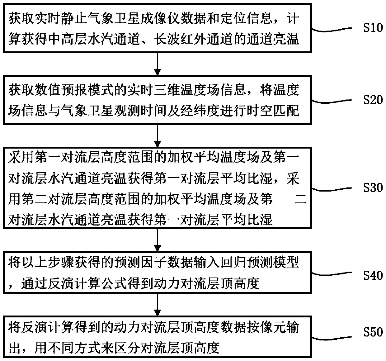
[0077] figure 1 It is a schematic diagram of the flow chart of the retrieval of dynamic tropopause height based on geostationary meteorological satellites in the present invention,

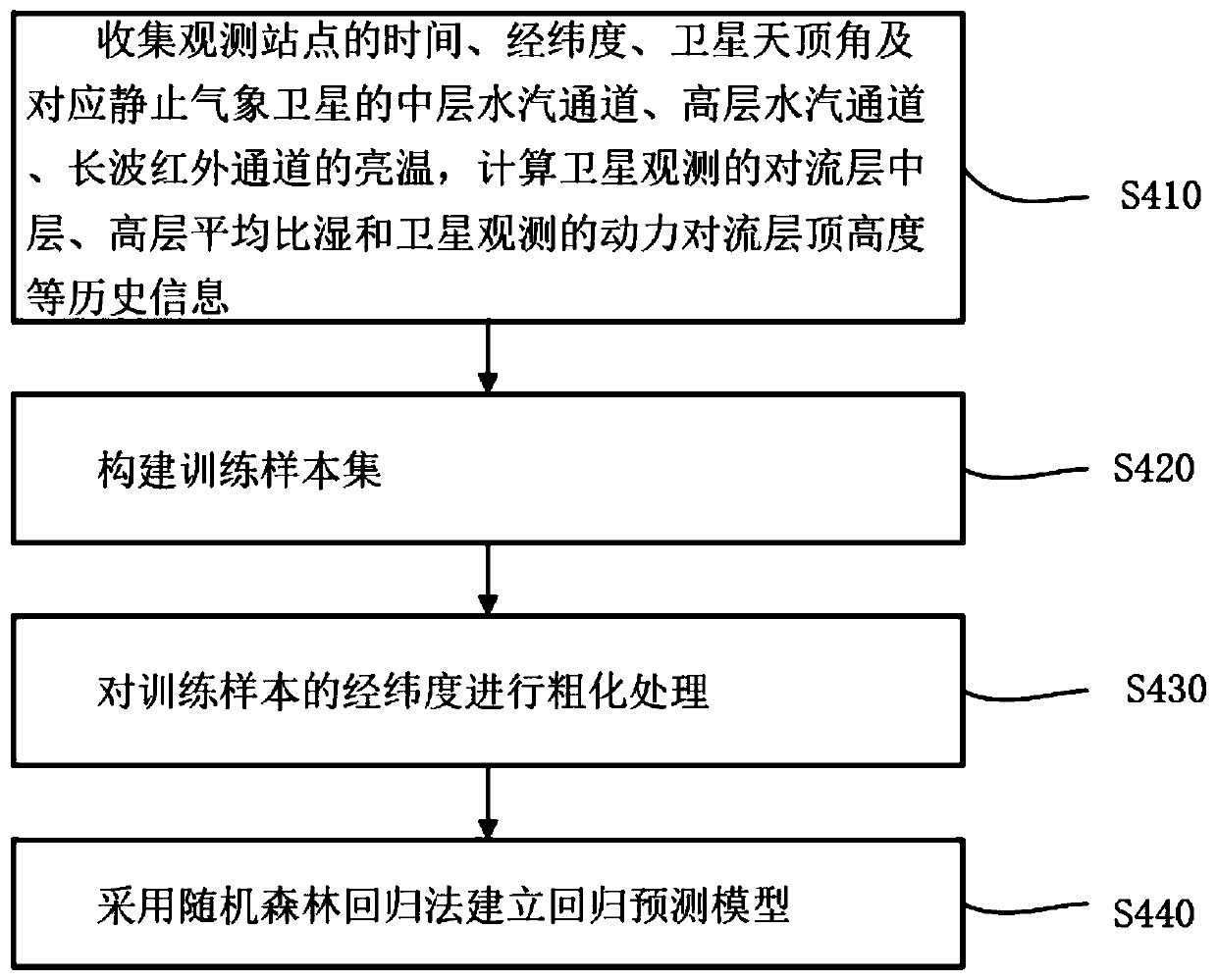
[0078] figure 2 It is a schematic flow chart of constructing a regression prediction model according to an example of the present invention;

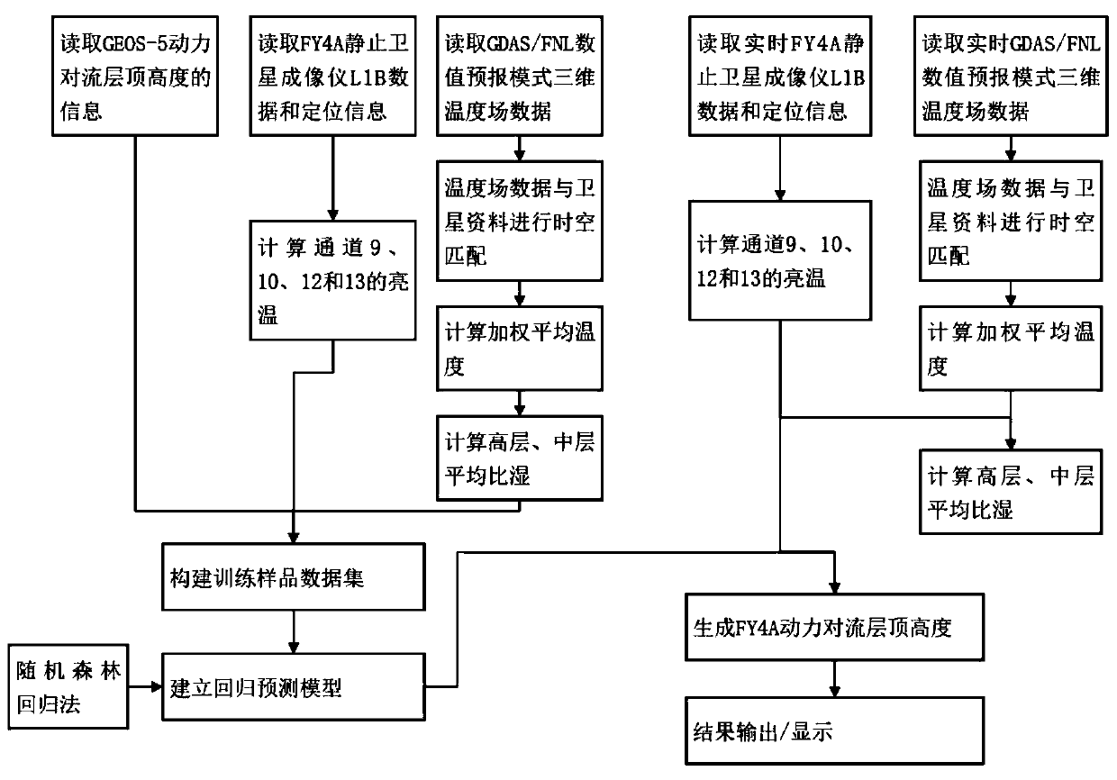
[0079] image 3 It is an example of the present invention based on Fengyun 4 A star multi-channel scanning imaging radiometer inversion schematic diagram of dynamic tropopause height;

[0080] In this embodiment, the first troposphere is the upper troposphere, and the second troposphere is the middle troposphere.

[0081] The method for retrieving the height of tropopause powered by meteorological satellites comprises the following steps:

[0082] Step S10: Obtain real-time stationary meteorological satellite imager data and positioning information, and calculate the brightness temperature of the middle and upper water vapor channel and the brightness ...

no. 2 example

[0132] For the above method, the embodiment of the present invention also provides a device for retrieving the height of the tropopause powered by a meteorological satellite, the device comprising:

[0133] The stationary meteorological satellite information acquisition unit is used to obtain the real-time stationary meteorological satellite imager data and positioning information after positioning and calibration processing;

[0134] The channel brightness temperature calculation unit is used to calculate the brightness temperature of the first tropospheric water vapor channel, the brightness temperature of the first tropospheric water vapor channel, and the brightness temperature of the long-wave infrared channel;

[0135] A three-dimensional temperature field information acquisition unit, configured to acquire real-time three-dimensional temperature field information, and perform time-space matching of the temperature field information with the observation time and latitude an...

no. 3 example

[0143] Regarding the method of the first embodiment, the present invention also provides a storage medium, on which a computer program is stored, and when the program is executed by a processor, the meteorological satellite-based dynamic tropopause height inversion described in the first embodiment is realized. method steps.


PUM


Abstract

The invention discloses a meteorological satellite dynamic tropospheric top height inversion method, and the method comprises the following steps: obtaining the data and positioning information of a real-time static meteorological satellite imager, and calculating the brightness temperature of a middle-layer water vapor channel, the brightness temperature of a high-layer water vapor channel and the brightness temperature of a long-wave infrared channel; acquiring real-time three-dimensional temperature field information of the numerical forecasting mode, and performing space-time matching witha meteorological satellite; obtaining the average specific humidity of the middle layer and the high layer of the troposphere, inputting the obtained prediction factor data into a regression prediction model, and obtaining the top height of the dynamic troposphere through an inversion calculation formula; and outputting a result obtained by inversion calculation according to pixels. The tropospheric top height result obtained through the inversion method is consistent with the inversion result in the prior art, effectiveness is achieved, dynamic tropospheric top height data with higher spatial resolution and time resolution than an existing inversion method can be obtained, and obtaining of mesoscale structure information and weather and climate characteristics of the tropospheric top isfacilitated.

Description

technical field [0001] The invention relates to the technical field of meteorological remote sensing, in particular to a method, device, storage medium and computer equipment for retrieving the height of the tropopause powered by a meteorological satellite. Background technique [0002] The tropopause is the upper boundary of the troposphere, the transition layer between the troposphere and the stratosphere. In this region, atmospheric properties such as potential vorticity, water vapor, temperature, and chemical property levels such as ozone, sulfur dioxide, carbon dioxide, and many nitrogen oxide concentrations undergo abrupt changes. The tropopause of the atmosphere is not only affected by weather development and has diurnal variation characteristics, but also changes with latitude and seasonal changes. [0003] From the end of the 19th century to the present, various definitions of the tropopause have been given internationally from different perspectives, for example, ...

Claims


Application Information

Patent Timeline
Patent Type & Authority Applications(China)
IPC IPC(8): G06K9/62G06F17/18G01W1/10
CPCG06F17/18G01W1/10G06F18/214Y02A90/10
Inventor 寿亦萱陆风崔鹏张晓虎
Owner NAT SATELLITE METEOROLOGICAL CENT
Why Eureka
Try Eureka