An infrared-inertial integrated navigation method for large-scale scenes with low visibility

A low-visibility and inertial combination technology, which is applied in the field of infrared inertial integrated navigation, can solve the problems of image resolution drop and affect the accuracy of visual positioning, etc., and achieve the effect of increasing the distance between frames, high update rate and improving resolution

Active Publication Date: 2022-01-25
XIAN AVIATION COMPUTING TECH RES INST OF AVIATION IND CORP OF CHINA
View PDF0 Cites 0 Cited by
  • Summary
  • Abstract
  • Description
  • Claims
  • Application Information

AI Technical Summary

Problems solved by technology

However, during the downsampling process, the resolution of the image decreases, which directly affects the accuracy of visual positioning.

Method used


Image

  • An infrared-inertial integrated navigation method for large-scale scenes with low visibility
  • An infrared-inertial integrated navigation method for large-scale scenes with low visibility
  • An infrared-inertial integrated navigation method for large-scale scenes with low visibility

Examples


Embodiment Construction

[0075] The present invention will be described in detail below in conjunction with the accompanying drawings and specific embodiments.

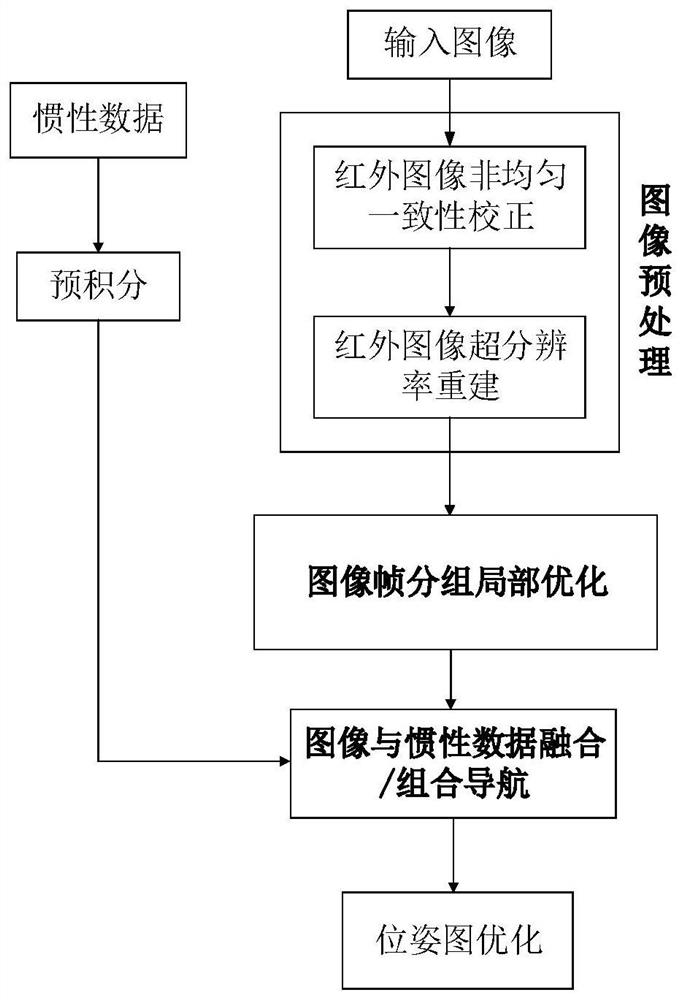
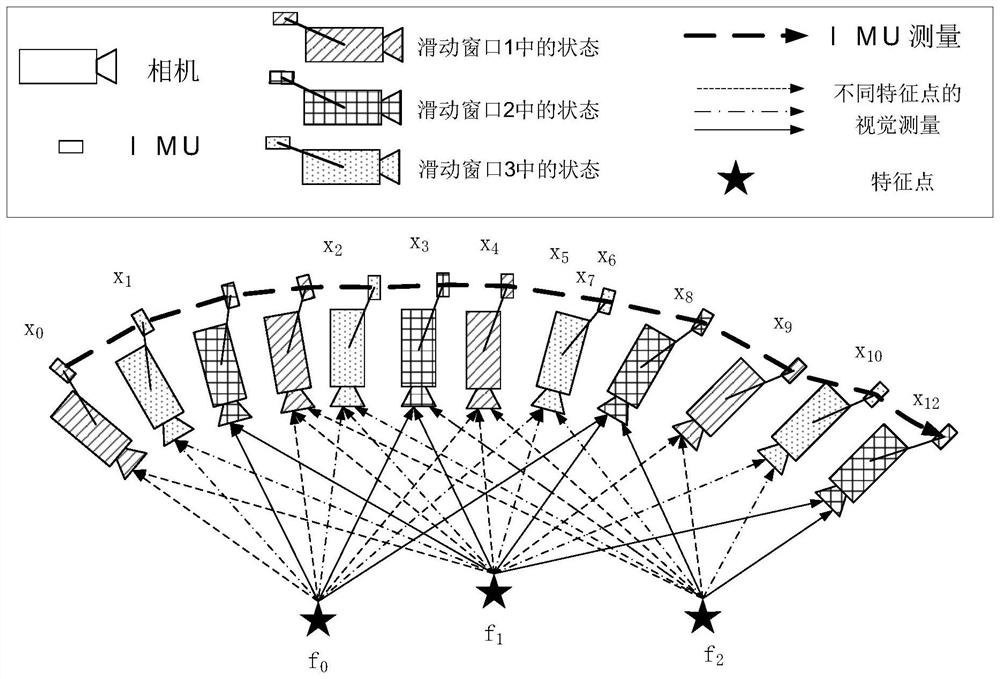
[0076] The present invention provides an infrared inertial integrated navigation method for low-visibility large-scale scenes, the flow chart is as follows figure 1 As shown, the implementation can be divided into the following four steps:

[0077] Step 1. Use the short-wave infrared camera on the carrier to detect the target scene, obtain a short-wave infrared image, and use the inertial measurement unit on the carrier to obtain inertial data.

[0078] Since infrared imaging can observe information in bands other than visible light, and is not affected by day and night and weather, and has a strong ability to penetrate smoke and haze, short-wave infrared cameras are selected to detect target scenes.

[0079] Step 2. Perform image preprocessing on the short-wave infrared image to improve the resolution of the short-wave infrared image.

[0...


PUM


Abstract

Aiming at the simultaneous positioning and map construction requirements under complex meteorological conditions and large-scale scenes, the present invention proposes an infrared inertial integrated navigation method for low-visibility large-scale scenes. First, a short-wave infrared camera is used to adapt to scene detection under low-visibility meteorological conditions. Secondly, the image super-resolution reconstruction technology is adopted to solve the problem of low resolution of infrared images. Again, aiming at, the present invention adopts the method of local optimization of short-wave infrared image frame grouping, which overcomes the problem that the baseline distance between frames is relatively short and cannot be located in large-scale scenes. Finally, design visual / inertial integrated navigation to obtain high update rate and high precision motion status. The invention has the characteristics of strong robustness, low cost and high precision.

Description

technical field [0001] The invention belongs to the field of computer vision navigation, and in particular relates to an infrared inertial combined navigation method for low-visibility large-scale scenes. Background technique [0002] In recent years, with the emergence of new technologies and concepts such as big data technology, high-performance computing technology, and deep learning technology, artificial intelligence technology has made remarkable progress. Advantages such as adaptability to the terrain environment have become the core elements of the future unmanned and intelligent strategic system construction. [0003] At present, the positioning and navigation of unmanned vehicles mainly include inertial navigation, global satellite navigation, radio navigation positioning and range reckoning, visual navigation and other methods. Inertial navigation has high precision, but its large size, heavy weight, and high price limit its scope of application; global satellite...

Claims


Application Information

Patent Timeline
Patent Type & Authority Patents(China)
IPC IPC(8): G01C21/16G01C21/20
CPCG01C21/165G01C21/20
Inventor 张磊刘硕文鹏程
Owner XIAN AVIATION COMPUTING TECH RES INST OF AVIATION IND CORP OF CHINA
Why Eureka
Try Eureka