Multi-class unbalanced remote sensing land cover image classification method based on integrated intervals

A technology of land cover and remote sensing images, which is applied in the field of multi-class imbalanced remote sensing classification, can solve the problems of small differences between base classifiers, heavy noise samples, and low operating efficiency, and achieve high classification accuracy, fast training speed, and Noise-capable effect

Pending Publication Date: 2020-09-18
XIDIAN UNIV
View PDF0 Cites 6 Cited by
  • Summary
  • Abstract
  • Description
  • Claims
  • Application Information

AI Technical Summary

Problems solved by technology

This method has small differences between each base classifier and weak generalization ability
The Boosting algorithm can determine the weight of the next sample to be selected according to the classification result of the previous base classifier, but this method is too heavy on the noise sample, the base classifier needs serial iterations, and the operation efficiency is low

Method used


Image

  • Multi-class unbalanced remote sensing land cover image classification method based on integrated intervals
  • Multi-class unbalanced remote sensing land cover image classification method based on integrated intervals
  • Multi-class unbalanced remote sensing land cover image classification method based on integrated intervals

Examples


Embodiment Construction

[0022] specific implementation plan

[0023] The embodiments and effects of the present invention will be described in detail below in conjunction with the accompanying drawings.

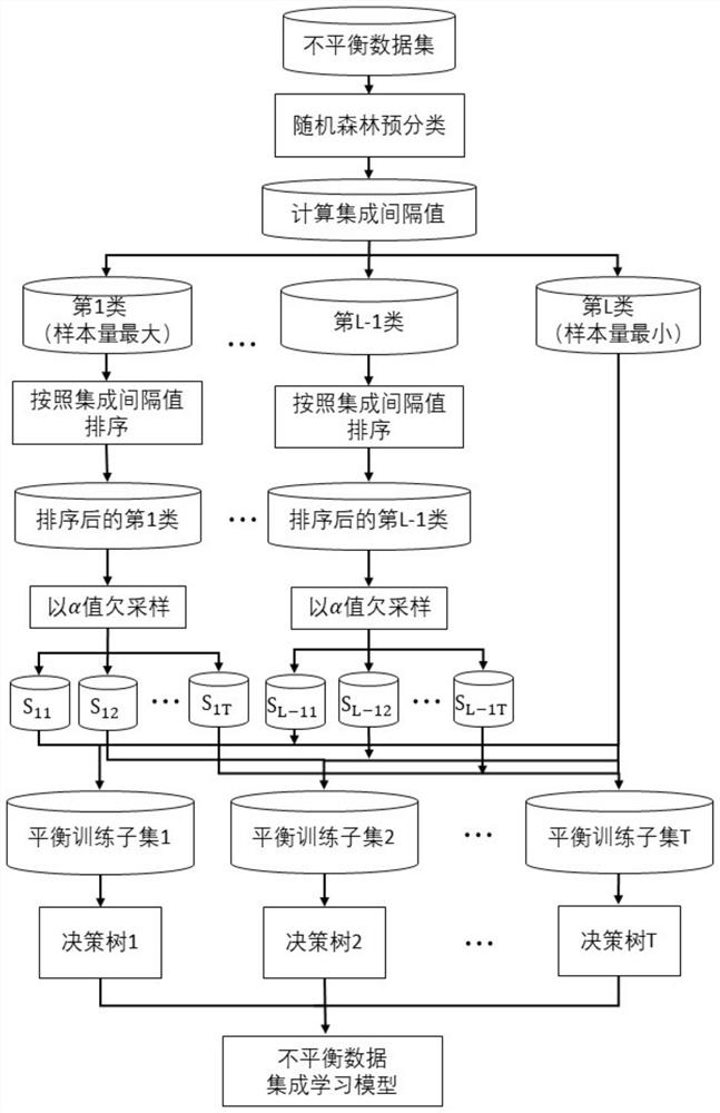
[0024] refer to figure 1 , the implementation steps of the present invention are as follows:

[0025] Step 1: Obtain unbalanced training samples.

[0026] Training samples are usually obtained from field surveys, manually extracted from high-spatial resolution images, or obtained from existing remote sensing image classification training databases. The training samples in this embodiment come from, but are not limited to, the Landsat satellite multispectral data of the UCI training database.

[0027] Step 2: Pre-classify the training samples using the random forest classification algorithm.

[0028] Commonly used classification algorithms for remote sensing images include maximum likelihood method, K-nearest neighbor method, and support vector machine.

[0029] This embodiment adopts but is not...


PUM


Abstract

The invention discloses a multi-class unbalanced remote sensing land cover image classification method based on integrated intervals, and mainly solves the problem of low classification precision of unbalanced images in the prior art. According to the implementation scheme, the method comprises the following steps: acquiring an unbalanced training sample, and pre-classifying the unbalanced training sample by using a random forest classification algorithm; counting voting numbers of the pre-classified unbalanced training samples, and establishing an integrated interval model based on voting; sorting the unbalanced training samples according to the number of the samples and the integrated interval value, reserving the minimum class, randomly selecting the samples from the rest classes at anundersampling rate, and constructing a new balanced training subset; and inputting each new balance training subset into the CART decision tree, and generating an ensemble learning model through a main voting principle to obtain a final classification result of the unbalanced remote sensing image. The method can effectively reduce the loss of useful information during classification through the integrated interval model, is high in anti-noise capability, is high in training speed, and can be used for land cover and environment monitoring.

Description

technical field [0001] The invention belongs to the field of remote sensing image processing, in particular to a remote sensing classification method with multi-class imbalance, which can be used for land cover and environmental monitoring. Background technique [0002] Imbalanced classification problems refer to classification problems in which the distribution of training samples among categories is unbalanced. Existing methods for solving imbalanced data classification problems can generally be divided into data-level methods and algorithm-level methods. in: [0003] Data-level methods usually resample the original data set to construct a new data set, which is mainly divided into oversampling and undersampling. The method of oversampling is to achieve the effect of balancing the data set by increasing the number of minority training samples. Commonly used oversampling methods include random oversampling and SOMTE algorithms. Because the random oversampling method dir...

Claims


Application Information

Patent Timeline
Patent Type & Authority Applications(China)
IPC IPC(8): G06K9/00G06K9/62
CPCG06V20/194G06V20/13G06F18/214G06F18/24323
Inventor 冯伟童莹萍全英汇邢孟道肖国尧董淑仙钟娴
Owner XIDIAN UNIV
Why Eureka
Try Eureka