Urban illegal building detection method based on high-resolution remote sensing image

A remote sensing image, high-resolution technology, applied in neural learning methods, biological neural network models, instruments, etc., can solve problems such as many manual participation, limited feature extraction ability, and poor robustness.

Pending Publication Date: 2021-01-29
NANJING KEBO SPACE INFORMATION TECH
View PDF0 Cites 13 Cited by
  • Summary
  • Abstract
  • Description
  • Claims
  • Application Information

AI Technical Summary

Problems solved by technology

The deep neural network can automatically learn the depth change features in complex situations, which solves the shortcomings of classic image processing methods in image change detection, such as more manual participation, poor robustness, and limited feature extraction capabilities.

Method used


Image

  • Urban illegal building detection method based on high-resolution remote sensing image
  • Urban illegal building detection method based on high-resolution remote sensing image
  • Urban illegal building detection method based on high-resolution remote sensing image

Examples


Embodiment Construction

[0036]The specific embodiments of the present invention will be described in further detail below in conjunction with the drawings and embodiments. The following examples are used to illustrate the present invention, but not to limit the scope of the present invention.

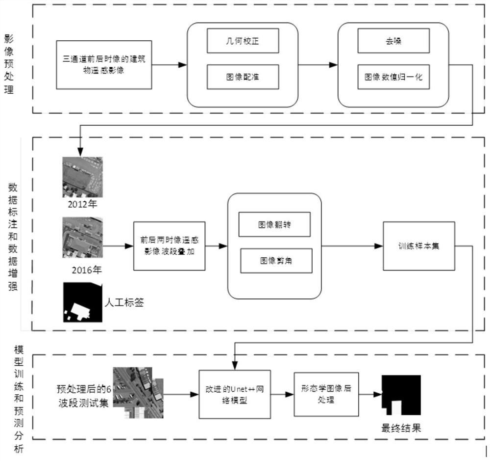
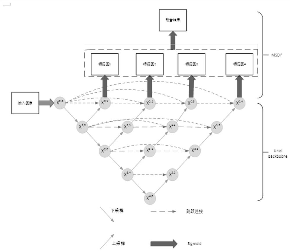
[0037]High-resolution remote sensing building violation detection method based on deep learning, such asfigure 1 As shown, for the front and back two temporal remote sensing images of the same area, the two high-resolution remote sensing images are first geometrically corrected and image registered; the GDAL library is used to superimpose the two temporal remote sensing images and then cut into a fixed size. , Use labelme to label the buildings with changes in the front and back two temporal images to make training set samples; train the improved Unet++ deep learning network model; perform the same preprocessing on the front and back two temporal images of the remote sensing image where you want to detect whether the b...


PUM


Abstract

The invention relates to the technical field of urban construction, in particular to an urban illegal building detection method based on a high-resolution remote sensing image, and aims to extract building change characteristics of front and rear time phases of the remote sensing image, obtain a building change result binary image, compare the building change result binary image with a governmentplanning map and detect illegal buildings. Convenient information support is provided for urban planning management. The method comprises the following steps: (1) performing geometric correction, image registration, denoising and normalization preprocessing on high-resolution remote sensing images of front and rear time phases to obtain high-resolution remote sensing image data with relatively consistent distribution; (2) cutting the preprocessed front and back time phase high-resolution remote sensing images by adopting the same size; and (3) carrying out waveband superposition on the segmented front and back time phase high-resolution remote sensing images by using a GDAL library to obtain a six-channel remote sensing building fusion image.

Description

Technical field[0001]The invention relates to the technical field of urban construction, in particular to a method for detecting illegal urban buildings based on high-resolution remote sensing images.Background technique[0002]With the rapid development of urbanization and industrialization in my country, the urban population has grown rapidly, the scale of urban land has continued to expand, and the demand for land has also become stronger. The phenomenon of illegal land use throughout the country continues to occur, and how to effectively control this situation has become very urgent. Therefore, how to effectively resist the phenomenon of illegal and illegal land use and form a good social atmosphere for land use in accordance with the law restricts the sustainable development of my country's economy. At the same time, with the improvement of national laws and regulations, the law enforcement of land supervision has become more and more stringent. It should not be too late to impro...

Claims


Application Information

Patent Timeline
Patent Type & Authority Applications(China)
IPC IPC(8): G06K9/00G06K9/62G06N3/04G06N3/08
CPCG06N3/08G06V20/176G06N3/045G06F18/22
Inventor 柯福阳王明明高申许九靖宋宝金文波
Owner NANJING KEBO SPACE INFORMATION TECH
Why Eureka
Try Eureka