Laser point cloud-based line tower footing terrain automatic extraction and mapping method

A laser point cloud and automatic extraction technology, applied in image enhancement, image analysis, image data processing, etc., can solve problems such as consumption, achieve high efficiency, fast speed, and improve work efficiency

Pending Publication Date: 2021-02-19
POWERCHINA HEBEI ELECTRIC POWER SURVEY & DESIGN INST CO LTD
View PDF4 Cites 0 Cited by
  • Summary
  • Abstract
  • Description
  • Claims
  • Application Information

AI Technical Summary

Problems solved by technology

After exporting the surveying data to the computer in the office, the "CASS Digital Topographic Cadastral Mapping System" is used to generate the topographic map of the tower base. The traditional GPS or total station collects the topographic data of the tower base of the line, and surveyors need to go to the tower site for on-site surve

Method used


Image

  • Laser point cloud-based line tower footing terrain automatic extraction and mapping method
  • Laser point cloud-based line tower footing terrain automatic extraction and mapping method

Examples


Embodiment Construction

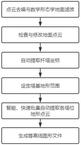
[0021] (1) Denoising and filtering of laser point cloud

[0022] The laser point cloud acquired by the airborne radar includes multiple echo data. Compared with the ground objects that may have multiple echoes, the ground point can only be considered as the last echo; the initial ground surface is extracted from the lower laser point by using the last echo. The mathematical morphology filtering method is used to obtain a reasonable ground point cloud and prepare data for subsequent DEM production.

[0023] (2) Check and modify ground point cloud data

[0024] Manually combine the image data, check the ground point cloud obtained in step (1), remove noise points such as houses and vegetation, and manually add the missing ground point cloud to form the final ground point cloud data.

[0025] (3) Processing tower coordinates

[0026] Utilize the digital orthophoto image DOM, digital elevation model DEM, point cloud data, and line mapping and supplementary measurement data to op...


PUM


Abstract

The invention discloses a laser point cloud-based line tower footing terrain automatic extraction and mapping method. The method comprises the following steps: denoising and filtering ground point cloud data acquired by a laser radar, repairing the ground point cloud data, processing tower coordinates, setting a tower footing terrain range, processing full-line tower footing data in batches, and generating a contour map; through distance operation, extracting point clouds belonging to each tower position range intelligently, quickly and automatically in batches, and automatically storing as tower footing topographic data according to tower position names, so that designers can carry out design work such as tower footing leg matching and the like; using grid interpolation to generate contour line graphic files, and providing complete tower footing terrain files and graphic files for the design major; according to the invention, the tower footing terrain extraction speed is high, projectcost investment is reduced, manual labor is reduced, and remarkable economic and social benefits are achieved.

Description

technical field [0001] The invention belongs to the technical field of measuring overhead transmission lines in electric power engineering, and in particular relates to a method for automatically extracting and mapping the terrain of line tower bases based on laser point clouds. Background technique [0002] In the survey and design of transmission lines, power towers are often located in complex terrain such as mountain tops, mountainsides, hills, wastelands, etc. It is necessary to survey and draw tower base topographic maps, especially for mountainous lines, where the role of tower base topographic maps is even more important. For tower positions in mountainous and hilly areas, surveying professionals are required to actually measure the topographic map of the tower base at the tower position, so that designers can determine the configuration of high and low legs and check the jumper wires of corner towers on site. There must be enough terrain points near the tower legs, ...

Claims


Application Information

Patent Timeline
IPC IPC(8): G06T17/05G06T15/00G06T5/00G06F30/13G06Q50/06G01S7/48G01S17/89
CPCG06T17/05G06T15/005G06T5/002G06F30/13G06Q50/06G01S17/89G01S7/4802G06T2207/10028Y02A90/10
Inventor 刘安涛毛玉丽
Owner POWERCHINA HEBEI ELECTRIC POWER SURVEY & DESIGN INST CO LTD
Why Eureka
Try Eureka