Satellite image and machine learning water quality monitoring method and system

A technology of satellite imagery and machine learning, applied in neural learning methods, integrated learning, instruments, etc., can solve the problems of less effective use of data, long satellite load revisit cycle, short satellite load transit cycle, etc.

Active Publication Date: 2021-03-09
清华苏州环境创新研究院 +1
View PDF13 Cites 8 Cited by
  • Summary
  • Abstract
  • Description
  • Claims
  • Application Information

AI Technical Summary

Problems solved by technology

[0006] a. The transit period of the satellite load is short, and the spatial resolution of the satellite load is often low, so it is difficult to effectively monitor the tiny target objects;
[0007] b The spatial resolution of the image is high, but the revisit period of the satellite load is often long, and it is impossible to conduct short-term continuous monitoring of the target object
At the same time, satellite remote sensing images are also affected by cloud cover, which can effectively use less data, and it is difficult to realize long-term continuous monitoring of fine ground objects.

Method used


Image

  • Satellite image and machine learning water quality monitoring method and system
  • Satellite image and machine learning water quality monitoring method and system
  • Satellite image and machine learning water quality monitoring method and system

Examples


Embodiment

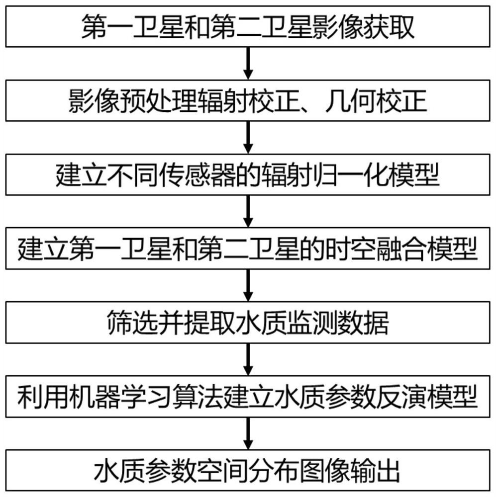
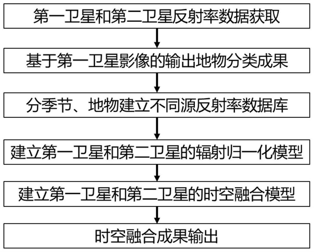
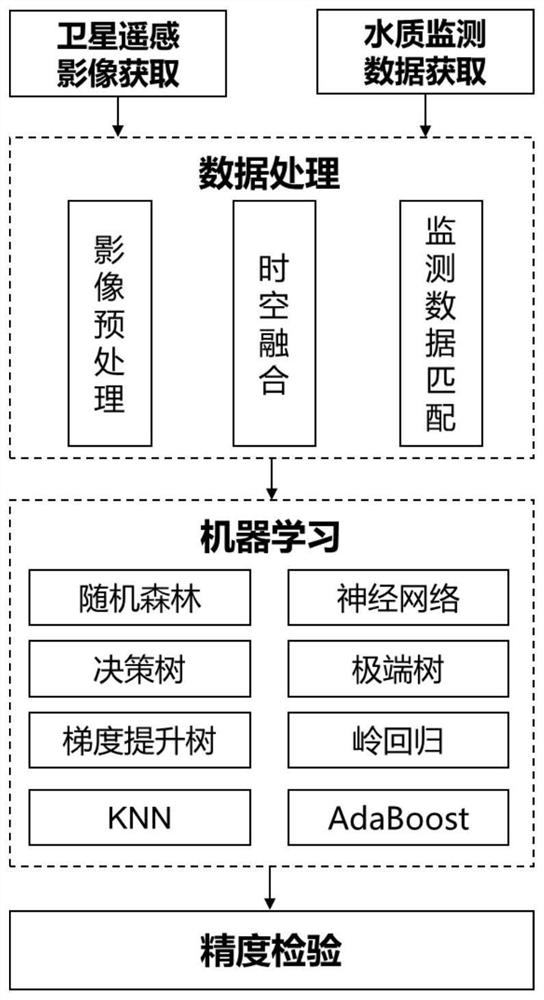
[0077] A water quality monitoring system based on satellite images and machine learning, mainly including remote sensing image acquisition module, remote sensing image preprocessing module, different source remote sensing image radiation normalization module, remote sensing image space-time fusion module, water quality parameter inversion model module, water quality parameter Inversion result output module. The aim is to use the albedo data of remote sensing satellite images to obtain water quality parameter inversion results that can characterize the spatial distribution characteristics of surface water environmental quality through the water quality parameter inversion model. In order to solve the contradiction between time and space resolution of remote sensing images caused by the limitation of load hardware, an assimilation system of reflectance between different sensors was constructed, and a space-time fusion algorithm model based on spatial filtering was established to ...


PUM


Abstract

The invention discloses a satellite image and machine learning water quality monitoring method which comprises the following steps: respectively preprocessing acquired first satellite image data and second satellite image data to generate reflectivity data; establishing radiation normalization models of different sensors according to different seasons and different ground features; establishing aspace-time fusion model based on weight filtering; establishing a water quality parameter inversion database based on the time information of the space-time fusion result and the space information ofthe water quality monitoring data of the ground monitoring station; screening a water quality parameter inversion database, extracting data of the training set and the test set, and establishing an inversion model of the water quality parameters by utilizing multiple machine learning algorithms; and outputting a water quality inversion result according to the generated reflectivity image data setand the established water quality parameter inversion model. A water quality parameter inversion model based on machine learning is established, the model precision is high, and the obtained water quality parameter inversion result can reflect the spatial distribution condition of water quality parameters.

Description

technical field [0001] The invention belongs to the technical field of urban surface water environmental water quality monitoring, and in particular relates to a long-term continuous surface water quality monitoring method and system based on satellite images and machine learning. Background technique [0002] Surface water environment water quality monitoring is one of the main contents of environmental monitoring. It is to accurately, timely and comprehensively reflect the current situation and development trend of water quality, provide scientific basis for water environment management, pollution source control, environmental planning, etc. Pollution control as well as maintaining the health of the water environment plays a vital role. At present, there are mainly the following methods for surface water environmental water quality monitoring: [0003] Traditional urban surface water environmental water quality monitoring methods are mainly manual and automatic site monit...

Claims


Application Information

Patent Timeline
Patent Type & Authority Applications(China)
IPC IPC(8): G06K9/00G06K9/36G06K9/46G06K9/62G06F16/29G01N33/18G06N20/20G06N3/00G06N3/08
CPCG06F16/29G01N33/18G06N20/20G06N3/006G06N3/08G06V20/13G06V10/247G06V10/20G06V10/56G06F18/25
Inventor 何炜琪李继影吴志杰董世元张仁泉黄佳慧薛媛媛郭超硕陈蓉
Owner 清华苏州环境创新研究院
Why Eureka
Try Eureka