Mine autonomous three-dimensional surveying and mapping unmanned vehicle and surveying and mapping method

A mining and three-dimensional technology, which is applied in the field of independent three-dimensional surveying and mapping unmanned vehicles and surveying and mapping in mines, which can solve problems such as high professional quality requirements, high work intensity, and insufficient intuitive data

Pending Publication Date: 2021-11-02
福建飞虎无人机有限公司
View PDF0 Cites 2 Cited by
  • Summary
  • Abstract
  • Description
  • Claims
  • Application Information

AI Technical Summary

Problems solved by technology

[0005] 2. High working intensity
[0007] Even so, the above-mentioned measurement techniques still have the following disadvantages that need to be optimized: 1. The manual surveying and mapping method has high work intensity and low efficiency
High-precision surveying and mapping has high requirements for the performance of instruments and equipment and the professional quality of staff; 2. The results of manual surveying and mapping are generally planar maps, the information is not archived completely, and the displayed data is not intuitive enough
There are also certain limitations in the accuracy of surveying and mapping; 3. The currently used 3D laser surveying and mapping equipment still requires manual operation, which requires a long working hours in the surveying and mapping operation, and the efficiency is not high

Method used


Image

  • Mine autonomous three-dimensional surveying and mapping unmanned vehicle and surveying and mapping method
  • Mine autonomous three-dimensional surveying and mapping unmanned vehicle and surveying and mapping method
  • Mine autonomous three-dimensional surveying and mapping unmanned vehicle and surveying and mapping method

Examples


Embodiment 1

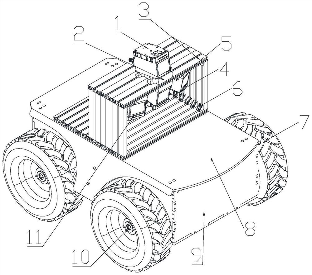
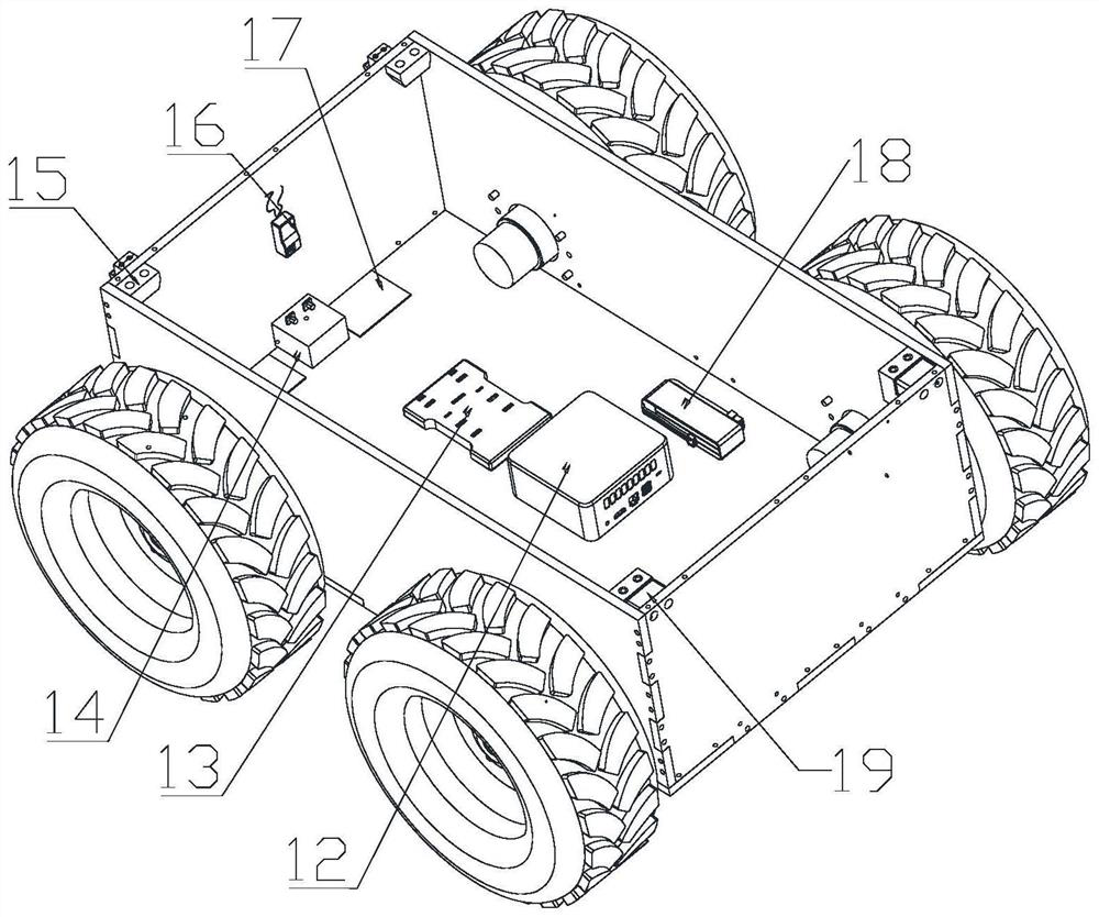
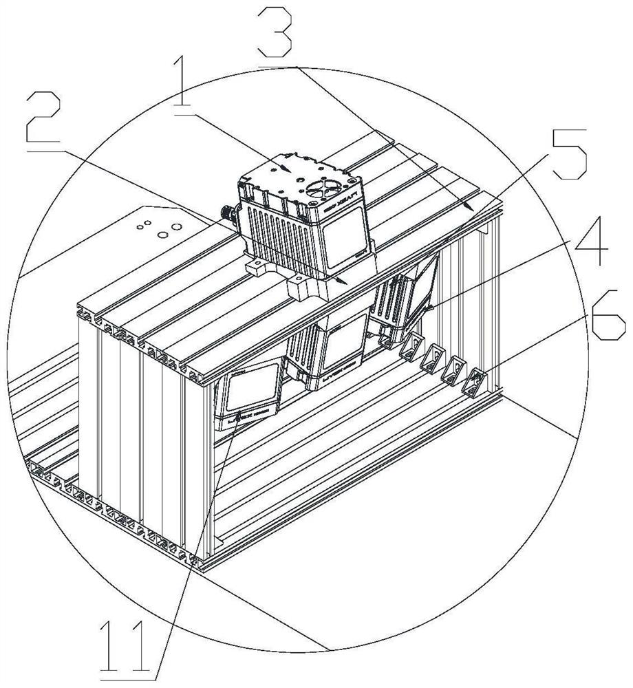
[0052] see Figure 1 to Figure 5 , the present embodiment provides an autonomous three-dimensional surveying and mapping unmanned vehicle for mines, including a vehicle body, an aluminum profile bracket 3, a laser radar, and a moving mechanism. Part 15, remote control receiver 16, drive plate 17, lithium battery 18 and front fastener 19, described vehicle body front portion is provided with front fender 9, and described vehicle body rear portion is provided with tailgate, and described micro host 12 and The controller 13 is fixed inside the vehicle body, and a communication line is provided to connect the two. The switching power supply 14 is installed at the rear of the vehicle body, and an Allen wrench is provided to turn on or off the power supply. The remote control receiver 16 is fixed on the Rear part, receive remote control signal, described driving board 17 is close to switching power supply 14, and described lithium battery 18 is used for power supply, is installed in...

Embodiment 2

[0066] Please refer to Figure 6 , this embodiment provides an autonomous three-dimensional surveying and mapping method for mines based on the UAV in the first embodiment above, including:

[0067] When the drone is traveling in the mine, all the laser radars on it collect the point cloud data of the current environment in real time, and send the corresponding point cloud data to the host frame by frame;

[0068] After the host receives the point cloud data of the current frame, it screens out high-value data points;

[0069] Preferably, the host will filter out point cloud data close to the edge of the FOV field of view, point cloud data with too large or too small intensity, and incident angles close to π or 0 point cloud data and point cloud data hidden behind objects to obtain high-value data points.

[0070] Then, the host calculates the local smoothness of the high-value data points, extracts plane feature points and edge feature points respectively, and obtains a pla...

Embodiment 3

[0090] This embodiment provides a method for completing autonomous mine surveying and mapping based on the UAV provided in Embodiment 1 or Embodiment 2. The method may specifically include the following steps:

[0091] Step 1: Collect the point cloud data in the current working environment in real time through the top lidar 1, the left-facing lidar 4, the bottom-facing lidar 5, and the right-facing lidar 11 on the drone, and collect each collected One frame of point cloud data is transmitted to the NUC micro-host 12 to execute the SLAM algorithm in real time.

[0092] Specifically, after the NUC micro-host 12 receives a frame of point cloud data, the process of executing the SLAM algorithm includes:

[0093] Step 11: Filter out high-value data points by calculating the features of the lidar point cloud P=[x, y, z] in the Front-Left-Up (FLU) coordinate system;

[0094] Specifically, filter according to the result of calculating each point cloud data according to the following ...


PUM


Abstract

The invention relates to a mine autonomous three-dimensional surveying and mapping unmanned vehicle and a surveying and mapping method. The method comprises the steps: enabling a laser radar on the unmanned vehicle to collect the point cloud data of a current environment in real time during the advancing process of the unmanned vehicle in the mine, and transmitting the corresponding point cloud data to a host frame by frame; enabling the host to screen out high-value data points, and acquiring a plane feature point set and an edge feature point set according to the high-value data points; performing iterative pose optimization calculation to obtain the pose of the unmanned vehicle corresponding to the current frame, and creating a three-dimensional map of the current frame; and according to the three-dimensional map, planning an advancing route of the unmanned vehicle in real time, and according to the advancing route, controlling the unmanned vehicle to advance through a controller. The surveying and mapping task in the mine can be autonomously completed, and the efficiency and the precision are high.

Description

technical field [0001] The invention relates to the field of mining, in particular to an autonomous three-dimensional surveying and mapping unmanned vehicle and a surveying and mapping method for mines. Background technique [0002] Mine surveying is a very important link in the process of geological exploration and mine mining, and it plays a guiding role in mine production. [0003] Mine surveying and mapping operations have the following characteristics: [0004] 1. The working environment is harsh. Due to the limitations of the working environment for mine surveying, most mines are located in remote locations, with inconvenient transportation and supplies. The staff also need to carry a large amount of materials and equipment when entering the mountain. Uncontrollable factors such as environment and climate will affect the accuracy and precision of mine surveying. . In addition, the accuracy of mine surveying and mapping is related to the professional quality of equip...

Claims


Application Information

Patent Timeline
Patent Type & Authority Applications(China)
IPC IPC(8): B62D63/02B62D63/04B60R11/00G06T17/05G06T19/00
CPCB62D63/02B62D63/04B60R11/00G06T17/05G06T19/003G06T2200/08
Inventor 邹诚徐萌蔡国玮
Owner 福建飞虎无人机有限公司
Why Eureka
Try Eureka