Karst rocky desertification area rock-soil interface form and soil information acquisition method

A technology for soil information and collection methods, applied in sampling devices and other directions, can solve the problems of difficulty in collecting thin layers of soil, no collection methods, and large spatial variability, so as to avoid cross-mixing pollution, ensure accuracy, and achieve scientificity. Effect

Pending Publication Date: 2021-11-12
GUIZHOU UNIV
View PDF3 Cites 2 Cited by
  • Summary
  • Abstract
  • Description
  • Claims
  • Application Information

AI Technical Summary

Problems solved by technology

Soil sample collection is a key link in obtaining soil information at the rock-soil interface. At present, there is no feasible collection method. It is difficult to collect samples close to the rock surface that can best reflect the characteristics of the rock surface soil by referring to existing sampling methods such as field soil and karst fissure soil. thin layer of soil
At the same time, the soil moisture and nutrients at the rock-soil interface have large spatial variability in the vertical and horizontal directions. Due to the influence of rock irregularities at the rock-soil interface, existing sampling methods cannot accurately describe the soil at the rock-soil interface qualitatively and quantitatively. level
Therefore, there is a lack of effective quantitative collection methods for rock-soil interface morphology and soil information in karst rocky desertification areas in the prior art

Method used


Image

  • Karst rocky desertification area rock-soil interface form and soil information acquisition method
  • Karst rocky desertification area rock-soil interface form and soil information acquisition method
  • Karst rocky desertification area rock-soil interface form and soil information acquisition method

Examples


Embodiment 1

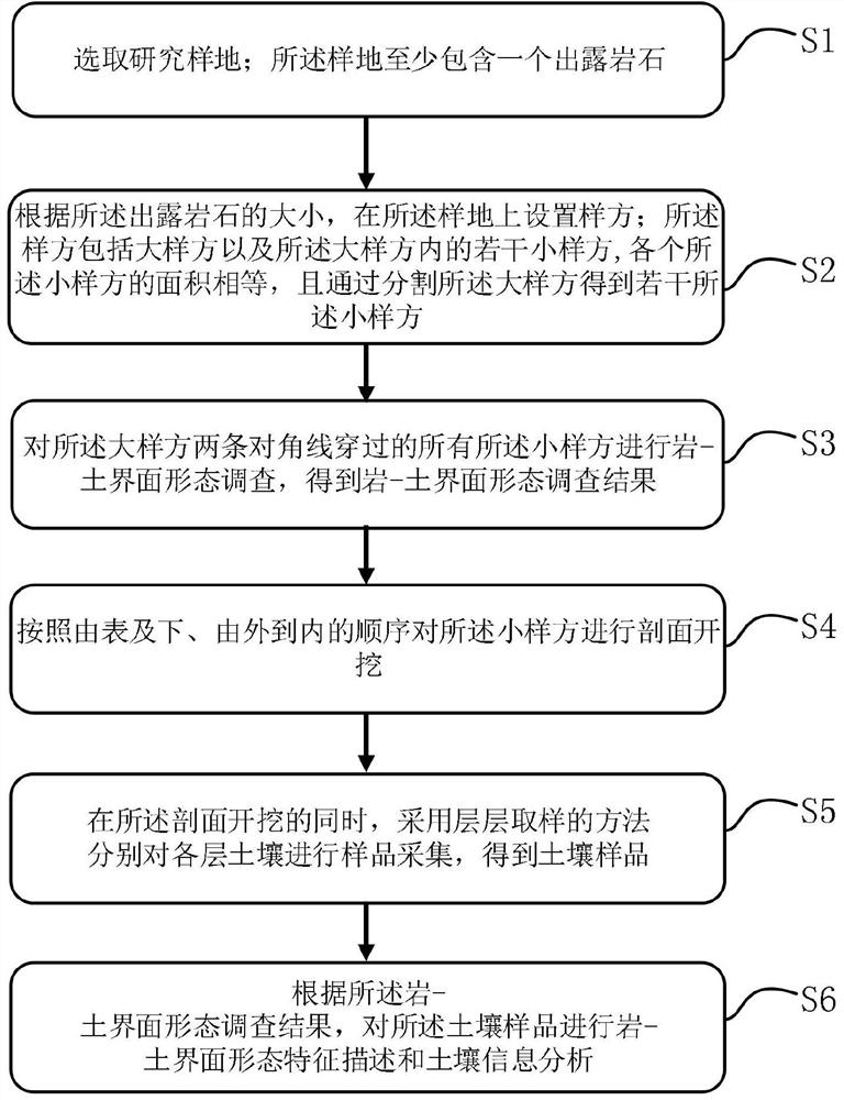
[0070] Such as figure 1 As shown, this embodiment proposes a method for collecting rock-soil interface morphology and soil information in karst rocky desertification areas. This method can measure the geometry, inclination, and undulation of the rock-soil interface through the sample method and the half-sample method. and other morphological characteristics, and realize the collection of soil samples at the rock-soil interface by setting the soil sampling thickness of the rock-soil interface, which provides new ideas and methods for the analysis of soil characteristics in karst rocky desertification areas, the evaluation of the effects of rocky desertification control measures, and the study of water and soil loss . This method mainly includes the process of selecting research plots, setting quadrats, morphology investigation, section excavation, sample collection, morphology and sample analysis, and specifically includes the following steps:

[0071] Step S1, selecting a res...

Embodiment 2

[0117] This example provides a straight rock-soil interface form and soil information collection method in a karst rocky desertification area. This example selects a representative rocky desertification slope farmland in Ganhe Village, Changshun County, Guizhou Province as a research The sample plot is located at 26°1′31″N, 106°29′58″E, 1002m above sea level, the rock type is limestone, the rock exposure rate is 30%, and the distance between corn plants is 1.5m×1.5m.

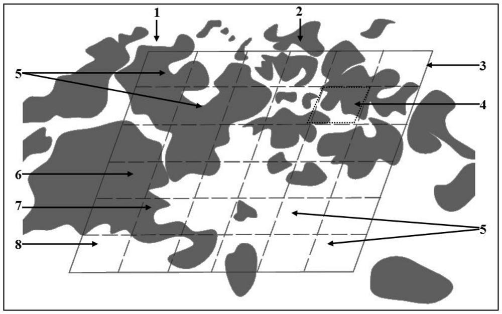
[0118] A 10m×10m large quadrat 3 was measured with a 50m measuring tape in the above-mentioned research plot. The rocks in the quadrat are isolated and typical in shape, and the rock outcropping rate is roughly the same as that of the research plot. The same; the large sample plot 3 is divided into 400 small sample plots 4 with a 0.5m×0.5m grid, and a total of 39 small sample plots 5 with a diagonal grid.

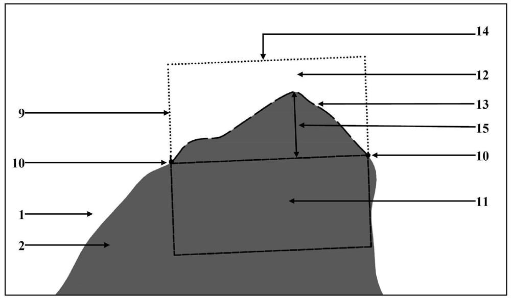
[0119] The morphological survey is carried out on the above-mentioned small sample plot 4 with both soil a...

Embodiment 3

[0128] This example provides a concave rock-soil interface morphology and soil information collection method in the karst rocky desertification area. In this example, a representative rocky desertification degraded farmland shrub land was selected as a research in Ganhe Village, Changshun County, Guizhou Province. The sample plot is located at 26°1′30″N, 106°29′59″E, 1005m above sea level, the rock type is limestone, the rock exposure rate is 45%, and the vegetation coverage rate is 60%.

[0129] A 10m×10m large quadrat 3 was measured with a 50m measuring tape in the above-mentioned research plot. The rocks in the quadrat are isolated and typical in shape, and the rock outcropping rate is roughly the same as that of the research plot. The same; the large sample plot 3 is divided into 400 small sample plots 4 with a 0.5m×0.5m grid, and a total of 39 small sample plots 5 with a diagonal grid.

[0130] The morphological survey is carried out on the above-mentioned small sample pl...


PUM

PropertyMeasurementUnit
lengthaaaaaaaaaa
angleaaaaaaaaaa
elongationaaaaaaaaaa

Abstract

The invention relates to a karst rocky desertification region rock-soil interface form and soil information acquisition method, and belongs to the field of rock-soil interface form and soil information acquisition. The method includes: firstly, selecting a research sample plot, wherein the sample plot at least comprises one exposed rock; according to the size of the exposed rock, arranging a quadrat on the sample plot, wherein the quadrat comprises a large quadrat and a plurality of small quadrats in the large quadrat; performing rock-soil interface form investigation on all small quadrats passing through two diagonals of the large quadrat to obtain a rock-soil interface form investigation result; performing section excavation on the small quadrats from outside to inside according to a sequence from outside to inside; performing sample collection on each layer of soil by adopting a layer-by-layer sampling method to obtain a soil sample; and performing rock-soil interface morphological feature description and soil information analysis on the soil sample according to a rock-soil interface morphological survey result. According to the method, accurate and effective quantitative acquisition and analysis of the rock-soil interface form and soil information of the karst rocky desertification region can be realized.

Description

technical field [0001] The invention relates to the field of rock-soil interface morphology and soil information collection, in particular to a rock-soil interface morphology and soil information collection method in a karst rocky desertification area. Background technique [0002] The exposed bedrock and soil in the karst rocky desertification area are interlaced, forming a widely distributed rock-soil interface. A certain area of ​​exposed rock face collects water, organic carbon and other substances into the surrounding soil system, which has a positive or negative impact on the interface and the surrounding soil. The geometry of exposed rocks in karst rocky desertification areas is extremely irregular, and there is no ready-made method to describe the morphological characteristics of rock-soil interface. Soil sample collection is a key link in obtaining soil information at the rock-soil interface. At present, there is no feasible collection method. It is difficult to co...

Claims


Application Information

Patent Timeline
Patent Type & Authority Applications(China)
IPC IPC(8): G01N1/04
CPCG01N1/04
Inventor 刘婷婷彭旭东李昌兰戴全厚许胜兵
Owner GUIZHOU UNIV
Why Eureka
Try Eureka