Automatic observation meteorological satellite thermal infrared channel on-orbit site radiometric calibration method

A meteorological satellite and automatic observation technology, applied in radiation pyrometry, optical radiation measurement, measuring devices, etc., can solve the problems of many observation parameters, difficult to control accuracy, and heavy workload, so as to improve calibration accuracy and save manpower , Improve the effect of calibration frequency

Pending Publication Date: 2021-11-19
NAT SATELLITE METEOROLOGICAL CENT
View PDF4 Cites 1 Cited by
  • Summary
  • Abstract
  • Description
  • Claims
  • Application Information

AI Technical Summary

Problems solved by technology

These have directly affected the preprocessing of satellite data and the production of standard products; the lack of authenticity testing of the measured physical parameters reduces the reliability and application of data products, and cannot meet all the requirements for providing models or algorithms for applications
In addition, the absolute calibration of the orbital site radiation requires a lot of manpower, material resources and financial resources. Therefore, it is necessary to overcome the imperfect calibration on the satellite, the large workload of the site calibration and the low frequency (one or two field tests can be carried out every year), and the field test. Synchronous observation experiments have a large workload, many observation parameters, complex data processing procedures, difficult control of precision, and high threshold for cross-calibration implementation.

Method used


Image

  • Automatic observation meteorological satellite thermal infrared channel on-orbit site radiometric calibration method
  • Automatic observation meteorological satellite thermal infrared channel on-orbit site radiometric calibration method
  • Automatic observation meteorological satellite thermal infrared channel on-orbit site radiometric calibration method

Examples


Embodiment Construction

[0027] The following will clearly and completely describe the technical solutions in the embodiments of the present invention with reference to the accompanying drawings in the embodiments of the present invention. Obviously, the described embodiments are only some, not all, embodiments of the present invention. Based on the embodiments of the present invention, all other embodiments obtained by those of ordinary skill in the art belong to the scope of protection of the present invention. In order to facilitate the understanding of the above-mentioned technical solutions of the present invention, the above-mentioned technologies of the present invention will be described below through specific usage methods The plan is described in detail.

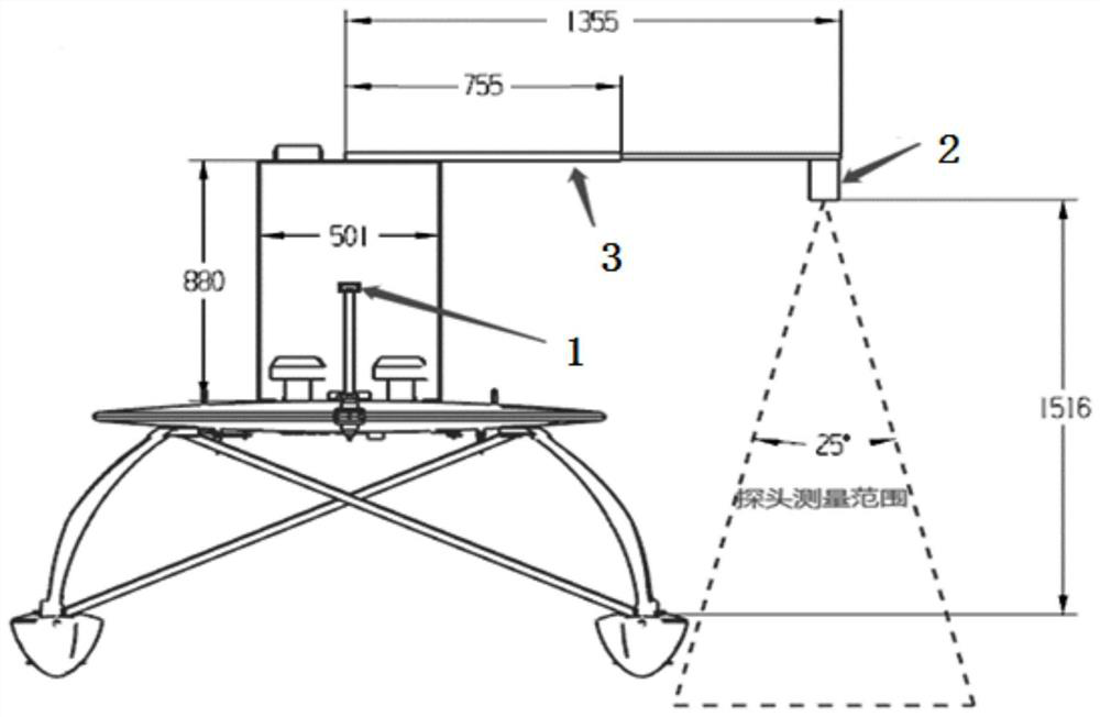
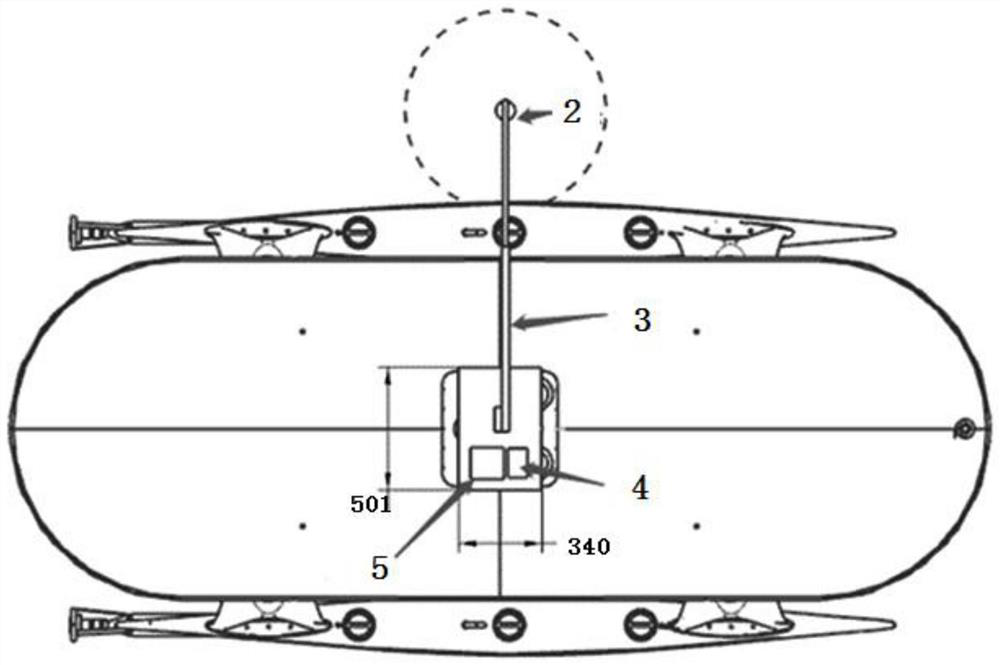
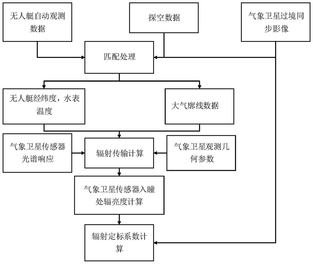
[0028] According to the method for calibrating on-orbit field radiation of thermal infrared channels of automatic observation meteorological satellites described in the embodiment of the present invention, the steps include, firstly, accord...


PUM


Abstract

The invention discloses an automatic observation meteorological satellite thermal infrared channel on-orbit site radiometric calibration method, which comprises the following steps that: acquiring lake surface water temperature observation data synchronously measured by a satellite and the ground by an unmanned ship water surface automatic observation system in an automatic data acquisition mode, and reading the observation data; after reading the observation latitude and longitude data of the unmanned ship, matching the observation latitude and longitude data with the observation data of a meteorological satellite; during matching, firstly, selecting matching points of a cloudless area, acquiring observation data on the matching points, and averaging pixel DN values of windows around meteorological satellite data; reading and processing sounding data, and performing matching; simulating to obtain the apparent radiance of an atmosphere top channel on each matching point; and performing linear regression calculation to obtain an absolute radiometric calibration coefficient of a to-be-calibrated channel. According to the method, the calibration frequency can be improved to a great extent by acquiring the encrypted sounding atmosphere profile data, and the calibration precision can be further improved.

Description

technical field [0001] The invention relates to the technical field of absolute radiation calibration of an infrared remote sensing sensor, in particular to a radiation calibration method for an on-orbit site of a thermal infrared channel of an automatic observation meteorological satellite. Background technique [0002] After half a century of hard work, my country has successfully launched 19 meteorological satellites, 9 of which are currently in orbit, forming a comprehensive earth observation capability that takes into account both imaging and detection, covering visible infrared microwave and other spectral bands, and has become the world's largest polar-orbiting satellite. One of the few countries that has two series of operational meteorological satellites, and geostationary. The new generation of polar-orbiting and geostationary meteorological satellites - Fengyun-3 and Fengyun-4 have realized the upgrading of my country's meteorological satellite observation system, ...

Claims


Application Information

Patent Timeline
Patent Type & Authority Applications(China)
IPC IPC(8): G01J5/52G01J5/00G01D21/02
CPCG01J5/00G01D21/02
Inventor 张勇王富张立军司一丹戎志国胡永红严林陈洪滨何文英郝小鹏
Owner NAT SATELLITE METEOROLOGICAL CENT
Why Eureka
Try Eureka