Mars elliptical orbit image motion compensation control ground verification system

A technology of image motion compensation and elliptical orbit, which is applied in the field of spacecraft testing, can solve the problems of difficulty in imaging near-fire arcs and low accuracy of orbit determination, and achieve the effects of good adequacy, improved verification efficiency, and reduced test costs

Pending Publication Date: 2021-12-14
SHANGHAI SATELLITE ENG INST
3 Cites 0 Cited by

AI-Extracted Technical Summary

Problems solved by technology

The remote sensing orbit of Mars is an elliptical orbit with precession. Because Mars is far away, the accuracy of orbit determination is relativ...

Method used

The virtual optical image real-time generation module is based on the imaging mechanism of the Mars high-resolution camera, and the three-dimensional fire surface scene is carried out to simulate optical imaging processing, that is, the three-dimensional Mars surface scene is projected to the camera detector imaging surface, and the virtual image is passed through the high-spe...

Abstract

The invention provides a Mars elliptical orbit image motion compensation control ground verification system. The Mars elliptical orbit image motion compensation control ground verification system comprises a ground object environment creation platform, a virtual optical image real-time generation module, a high-resolution camera storage processing simulation module and a high-resolution camera main control simulation module. According to the invention, the imaging result of interaction control between a Mars surrounding device attitude and orbit control system and an optical imaging load is visually presented in a full-software simulation manner, the problem of high relevance test between the surrounding device platform and the optical load is solved, and the interaction control ground verification capability between the platform and the load is realized. The system has a good effect on an optical load dynamic test of a deep space probe and the sufficiency of test verification. The system has the advantages of reducing the test cost, improving the verification efficiency, visually evaluating the dynamic imaging quality of a high-resolution camera under interaction control and the like.

Application Domain

Design optimisation/simulationAttitude control +1

Technology Topic

Verification systemPlanet Mars +10

Image

  • Mars elliptical orbit image motion compensation control ground verification system
  • Mars elliptical orbit image motion compensation control ground verification system
  • Mars elliptical orbit image motion compensation control ground verification system

Examples

  • Experimental program(1)

Example Embodiment

[0038] The present invention will be described in detail below in conjunction with specific embodiments. The following examples will facilitate further understanding of the present invention in any form of techniques, but will not limit the invention in any form. It should be noted that several variations and improvements can also be made without departing from the concept of the present invention. These are all of the scope of protection of the present invention.
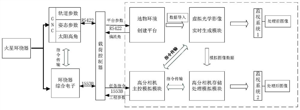
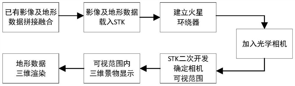
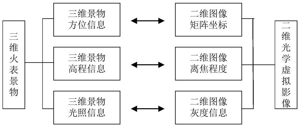
[0039] The present invention provides a Mars Elliptical Track Image Compensation Control Ground Verification System, and a one-to-one mapping relationship is established between the post-rail control parameter and the virtual optical imaging by three-dimensional landscape generation and virtual optical imaging. Software simulation mode visually presents imaging results of interaction control between posture rail control systems and optical imaging loads, and implementing interactive control of platform and load control ground verification. like figure 1 As shown, this verification system includes an art object environment creation platform, a virtual optical image real-time generation module, a high score camera storage processing analog module, and a high score main control analog module.
[0040] The ground object environment creation platform is randomly generated by the Mars Surface Surface Level Information, and the aberration environment creation platform real-time reception of the Mars surrounder's posture, including track parameters, posture parameters, and solar high corners, etc., said The ground object environment creation platform randomly generates the three-dimensional landscape information of Mars, and simulates the real ground object parameters and shadow effects according to the high-angle of the sun. The ground object environment creation platform realizes the simulation of the Mars surround view of the Mars, accurately determines the position of the surrounds, and displays the Mars surrounding area, determines the latitude latitude range of optical cameras And show three-dimensional landscape in the visible area.
[0041] In order to realize the simulation simulation of the Mars Surface Vision, Mars image and terrain data are collected, and the exact determination of the position of the surrounds run in the track, and displays the Mars Slope imaging coverage area to determine the optical camera imaging visible area. The latitude and longitude range, and the three-dimensional landscape in the visual area, three-dimensional rendering, according to the solar height angle and other light conditions simulated real ground objective parameters and shadow effect, reference figure 2 As shown, the specific process is as follows:
[0042] Step S1: Splicing the image of the acquired Mars and terrain data, and fused the overlap region;
[0043]Step S2: Mars will be loaded spliced ​​video and terrain data to STK software;
[0044] Step S3: to create a new scene and selects Mars central body, is established around the target Mars, disposed around the orbital parameters of the device;
[0045] Step S4: Add the optical camera on Mars around the device;
[0046] Step S5: the secondary development of STK, determining the visual range of an optical camera;
[0047] Step S6: displaying a three dimensional scene in the visible range;
[0048] Step S7: The three-dimensional scene within the visible range in step S6 3D rendering of terrain data.
[0049] The attitude control system to adjust the attitude and orbit drift angle according to information provided by an optical camera, according to a change of the attitude and orbit control system parameters may be acquired latitude and longitude of the optical visual range at any time the camera is on Mars around the surface of Mars. Around the device simulation time step can be set, it can be observed around the device in a simulation mode at different speeds around the fire fly. In different visual range, and you can see a three-dimensional scene the surface of Mars, and performs 3D rendering software, the surface of Mars in the visual range, three-dimensional surface of Mars acquiring scene information under different solar elevation angle, after the imaging transform a two-dimensional image of high pushbroom imaging.
[0050] Virtual imaging module optical image generated in real time based on the camera mechanism Mars high, the three-dimensional scene table fire analog optical imaging process, i.e. a three-dimensional scene is projected onto the surface of Mars surface imaging camera detector, and a virtual image output to the monitor by a high speed graphics card the camera system 1 and the high storage processing analog module, the camera image after the high storage process module for processing the analog, comparing the performance of the storage qualitative verification processing system, the effect of the image before processing the second output monitoring system.
[0051] The main role of the virtual image optical system is generated in real time an analog high-orbit imaging camera, the three-dimensional scene information to map the two-dimensional imaging surface. GNC parameter varies, the driving scene management unit three-dimensional landscape constantly updated information in real time to generate the virtual image optical system will also generate a virtual two-dimensional optical image in real time, the presence of the two-dimensional image defined between one pair of parameter and GNC a mapping relationship.
[0052] Virtual optical image generated in real time during system operation, you need to call around the orbital parameters of the device, the information attitude parameters, lighting conditions, Mars scores camera, Mars carve camera's optical parameters, based on the principle of optical imaging geometry, the fire watch different latitude and longitude the scene information is mapped to a different two-dimensional coordinate position of the image matrix, corresponding to different heights of the fire scene table to a two-dimensional image information of different levels of defocus (blur processing) state, the scene table corresponding to the fire information to two different light conditions dimensional gray value image, thereby achieving three-dimensionally Quanji Lu view information, such as the principle image 3 Indicated.
[0053] The camera module analog high storage process receiving and storing image data generated virtual image optical module output in real time, the image data and pre-stored downstream, according to a display command output analog high camera main control module. In the actual imaging performance track, track conditions at 260km, line frequency of approximately 8.1KHz, monolithic CCD 6144 for the number of pixels, each pixel stored in accordance with stored rate 2B, a single piece of 96MB / s, while the three CCD storage, speed near the maximum 300MB / s.
[0054] When the end of the image data storage, main control simulation system according to an instruction transmitted on the image data corresponding downlink pretreatment process embodiment comprises generating thumbnails and region extraction. Thumbnail extraction can be performed TDI CCD snapshot panchromatic 1 × 1,2 × 2,4 × 4,8 × 8,16 × 16 original image / fusion process; extraction area may be selected to determine the output region in the original image . High degree of simulation algorithms camera storage unit by the processing software model, processing algorithms may be connected through a dynamic link library into the software, processed by the model selection algorithm. Processing the image data into the display effect performance monitoring system, various algorithms stored verification process.
[0055] The camera main control module receives the analog high Mars surround an attitude and orbit control parameters, calculating a real image motion compensation, and image motion compensation parameters passed to the virtual image generated in real time the optical module, the optical virtual image generated in real time according to image motion compensation module parameters for image generation can be adjusted.
[0056] Score camera main simulation system is completed by a set of dedicated simulation system ground, the ground controller forwards the task instructions via the bus 1553B receive payload, the receiving platform attitude and orbit control system parameters broadcast by the RS422 bus for real-time calculation of image motion compensation the calculation result to the feedback the drift angle attitude and orbit control system to adjust the surround pose. Meanwhile, the real-time simulation of the master image motion compensation parameters (line frequency, the dimming stages other parameters) to the virtual image optical system is generated in real time via the RS422 interface, it generates an image be adjusted according to the parameters input. Further the master system and the analog processing of analog storage system by Gigabit Ethernet data exchange, after receiving the image storage processing analog preprocessing system, and then transmitted through the card serial LVDS output image data.
[0057] Main simulation system is based around the input attitude and orbit control unit calculates the attitude and orbit parameters in real time image motion compensation parameters, and adjusting the posture around the output parameters to surround an attitude and orbit control system, which will be corrected in real time according to the attitude adjustment command surround pose, during the operation of the verification system is a dynamic closed loop process.
[0058] Those skilled in the art know that the system and its various devices provided by the present invention can be made in addition to the system, modules, modules, and units of the present invention, in addition to the pure computer readable program code. The module, the unit implements the same function in the form of logic gates, switches, dedicated integrated circuits, programmable logic controllers, and embedded microcontrollers. Therefore, the system provided by the present invention and its various devices, modules, and the unit may be considered a hardware component, and the means, modules, modules, modules, and units included in it can also be considered in the hardware component. The structure; the device, module, module, module for implementing various functions, is also considered to be either a software module that implements a method or can be a structure within a hardware component.
[0059] In the description of this application, it is to be understood that the terms "top", "lower", "front", "post", "left", "right", "vertical", "horizontal", "top", The orientation or position of "bottom", "inside", "outside", etc. is based on the orientation or positional relationship shown in the drawings, which is merely described in this application and simplified description, rather than indicating or implying means of means. Or elements must have specific orientation, constructed and operated in a specific orientation, so it is not understood to limit the limitation of the present application.
[0060] The specific embodiments of the present invention will be described above. It is to be understood that the present invention is not limited to the above specific embodiments, and those skilled in the art can make various changes or modifications within the scope of the claims, which does not affect the substantial content of the present invention. In the case of an unable conflict, the features of the present application and the features in the embodiments may be combined with each other.

PUM

no PUM

Description & Claims & Application Information

We can also present the details of the Description, Claims and Application information to help users get a comprehensive understanding of the technical details of the patent, such as background art, summary of invention, brief description of drawings, description of embodiments, and other original content. On the other hand, users can also determine the specific scope of protection of the technology through the list of claims; as well as understand the changes in the life cycle of the technology with the presentation of the patent timeline. Login to view more.

Similar technology patents

Durability test device and method for water meter

ActiveCN111238607AReduce maintenance timesReduce test costs
Owner:HUNAN INST OF METROLOGY & TEST

Fatigue test bench of maize header

InactiveCN108318265AReduce test costslabor saving
Owner:佳木斯市质量技术监督检验检测中心

Wing flutter model frame segment structure

Owner:XIAN AIRCRAFT DESIGN INST OF AVIATION IND OF CHINA

Classification and recommendation of technical efficacy words

Why Eureka
Try Eureka