Multifunctional unmanned aerial vehicle for hydrographic survey

A hydrographic survey and unmanned aerial vehicle technology, applied in the field of unmanned aerial vehicles, can solve the problems of poor flight environment, inability to guarantee accuracy, and inability to collect and collect collected data in real time, and achieve the effect of compact structure and improved work efficiency.

Pending Publication Date: 2022-01-21
江苏雨能水利工程有限公司
View PDF8 Cites 0 Cited by
  • Summary
  • Abstract
  • Description
  • Claims
  • Application Information

AI Technical Summary

Problems solved by technology

[0004] However, there are some limitations in the application of UAVs in the field of hydrological monitoring.
First of all, traditional UAVs can only take off and land on the ground and navigate in the air, which limits UAVs to perform tasks on the water surface
The monitoring environment of hydrological monitoring is not limited to sunny weather and other weather. In severe weather conditions, it is also necessary to monitor the hydrology of rivers and lakes. However, due to the poor flying environment of existing drones in severe weather, operators cannot guarantee The accuracy of monitoring cannot be realized, and the collected and collected data can not be sent back in real time.

Method used


Image

  • Multifunctional unmanned aerial vehicle for hydrographic survey
  • Multifunctional unmanned aerial vehicle for hydrographic survey
  • Multifunctional unmanned aerial vehicle for hydrographic survey

Examples


Embodiment Construction

[0019] The accompanying drawings are for illustrative purposes only, and should not be construed as limitations on this patent; in order to better illustrate this embodiment, certain components in the accompanying drawings will be omitted, enlarged or reduced, and do not represent the size of the actual product; for those skilled in the art It is understandable that some well-known structures and descriptions thereof may be omitted in the drawings.

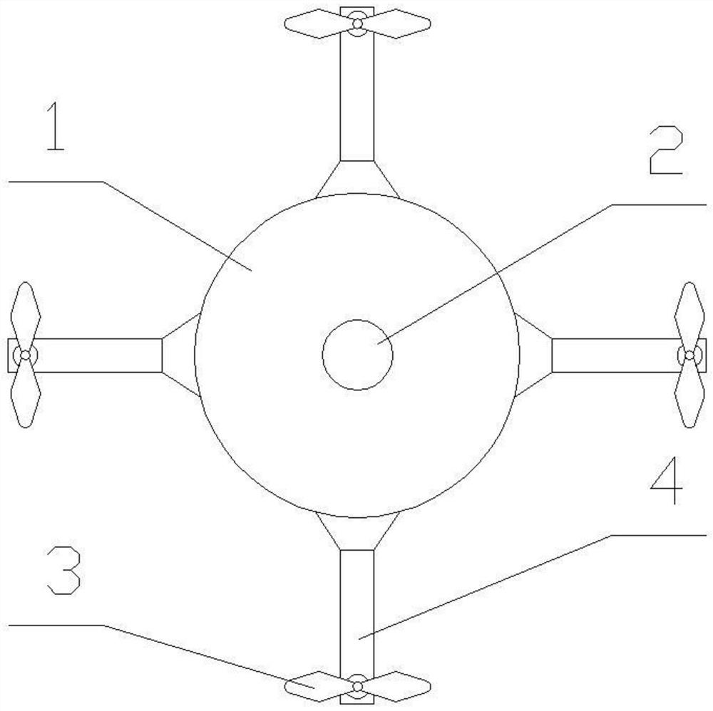
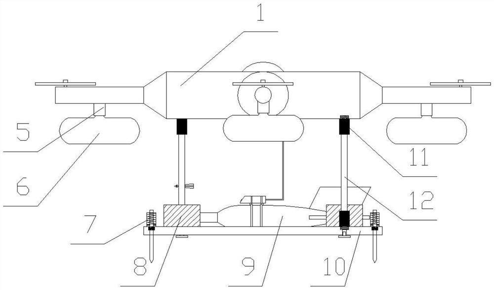
[0020] As shown in the figure: a multifunctional hydrographic surveying drone, including a drone body 1, the drone body 1 is round, and the drone body 1 is provided with a flying device, a floating devices and hydrographic measuring devices.

[0021] The top of the drone body 1 is provided with a warning light 2, and the four directions of the drone body 1 are respectively provided with four arms 4, and the ends of the four arms 4 are provided with propeller 3.

[0022] The floating device includes an air port 5 and an air bag 6...


PUM


Abstract

The invention relates to a multifunctional unmanned aerial vehicle for hydrographic survey; the multifunctional unmanned aerial vehicle comprises an unmanned aerial vehicle body, the unmanned aerial vehicle body is circular, and a flying device, a floating device and a hydrographic survey device are arranged on the unmanned aerial vehicle body; through the arrangement of a fish lead, the flow velocity and flow direction of water in hydrological monitoring are detected, sampling is carried out, and multifunctional hydrological measurement is achieved; through the arrangement of an air bag, the unmanned aerial vehicle can be prevented from being damaged by water entering the unmanned aerial vehicle after falling into water, and the lead fish can be submerged into the water to realize hydrological measurement operation; landing nails are arranged, so that the unmanned aerial vehicle can be installed under poor weather conditions, and the unmanned aerial vehicle can land safely; and through a wireless communication system of the unmanned aerial vehicle, data acquired by the Doppler probe can be transmitted back and analyzed in real time, so that the working efficiency is improved.

Description

technical field [0001] The invention belongs to the technical field of unmanned aerial vehicles, and in particular relates to a multifunctional unmanned aerial vehicle for hydrological survey. Background technique [0002] Hydrological monitoring refers to a complex and comprehensive systematic project that monitors, measures, analyzes and early-warning the temporal and spatial distribution and change rules of natural water through scientific methods. The hydrological monitoring system is suitable for hydrological departments to monitor rivers, lakes, reservoirs, Real-time monitoring of hydrological parameters such as channels and groundwater, monitoring content includes: water level, flow, flow velocity, etc. [0003] In order to protect water resources, prevent and control water pollution, improve water environment, and restore water ecology, the "river chief system" river and lake management and protection mechanism came into being. At the same time, hydrological monitor...

Claims


Application Information

Patent Timeline
Patent Type & Authority Applications(China)
IPC IPC(8): B64C39/02B64C25/56B64C25/32G01C13/00G01N1/10G01S15/58G01S19/42
CPCB64C39/02B64C25/56B64C25/32G01C13/006G01S19/42G01S15/58G01N1/10B64U2101/00
Inventor 袁红泉尹君袁飞周其建
Owner 江苏雨能水利工程有限公司
Why Eureka
Try Eureka