City three-dimensional map video stream encryption method and system based on artificial intelligence

A technology of artificial intelligence and three-dimensional map, which is applied in the field of artificial intelligence-based urban three-dimensional map video stream encryption and the release of urban three-dimensional video map, can solve the problems of unencrypted and cumbersome algorithm encrypted data, etc., to achieve enhanced protection and enhanced experience sexual effect

Active Publication Date: 2022-01-21
TERRA DIGITAL CREATING SCI & TECH (BEIJING) CO LTD
View PDF7 Cites 2 Cited by
  • Summary
  • Abstract
  • Description
  • Claims
  • Application Information

AI Technical Summary

Problems solved by technology

Since the video stream is a picture composed of multiple frames, it is obviously impossible to encrypt each frame in the irregular deformation method of a two-dimensional map, otherwise it will bring more cumbersome algorithms and a large amount of encrypted data

Method used


Image

  • City three-dimensional map video stream encryption method and system based on artificial intelligence
  • City three-dimensional map video stream encryption method and system based on artificial intelligence
  • City three-dimensional map video stream encryption method and system based on artificial intelligence

Examples


Embodiment 1

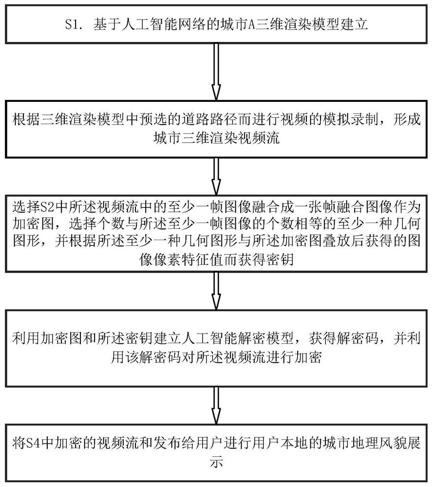
[0081] Such as figure 1 It is a flow chart of a method for encrypting a three-dimensional map video stream of city A based on artificial intelligence, which is characterized in that it comprises the following steps:

[0082] S1. Establishment of a 3D rendering model of city A based on the artificial intelligence network;

[0083] S2. Perform video simulation recording according to the pre-selected road path in the 3D rendering model to form a 3D rendering video stream of the city;

[0084] S3. Select at least one frame of image in the video stream in S2 to be fused into a frame fused image as an encrypted image, select at least one geometric figure whose number is equal to the number of the at least one frame of image, and according to the The key is obtained by superimposing at least one geometric figure and the image pixel feature value obtained after the encryption map;

[0085] S4. Establish an artificial intelligence decryption model by using the encryption graph and t...

Embodiment 2

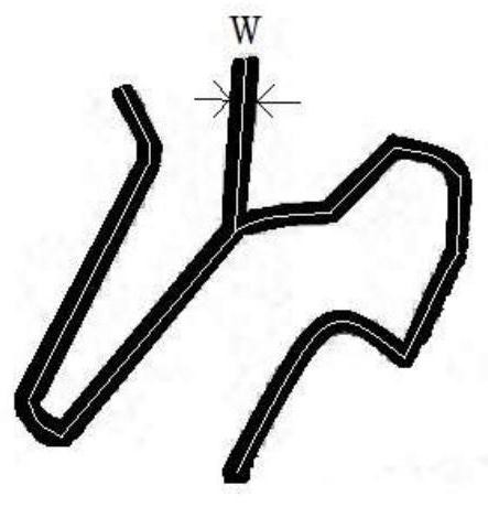
[0099] Carry out step S2 on the basis of embodiment 1, specifically include S2-1, such as Figure 4a shown, select Mod 3D The road centerline path L of interest in the width w, the preset shooting height h, the simulation camera C is set at the starting point of the path ( Figure 4a The position at height h=10m at C) on the middle right.

[0100] S2-2 Use the analog camera C to shoot and acquire at least one frame of image to complete the recording of the video stream; or, move the analog camera C from the starting point to the end point according to the road path ( Figure 4a Middle left C), the recording of the video stream is completed. The speed of the movement is according to Mod 3D The frame rate of the video stream is 60FPS when the scale of the model is converted to 1m / s in the real scene.

Embodiment 3

[0102] On the basis of embodiment 2, the path is reselected as Figures 4a-4d The flight path of Figure 4a The position of C in the corresponding real scene is the starting point, and S3-1 flies to Figure 4a Point C on the right side of the center is shot to complete the video stream. Then S3-2 divided the video stream into four time-sorted shooting video streams by presetting the first time, and randomly selected the first frame of each segment according to the Shuffle algorithm, a total of four images.

[0103] Such as Figure 5 , S3-3 splicing the four images in chronological order from upper left to upper right to lower left to lower right into a fusion image as an encrypted image. S3-4 selects four geometric figure edges (single pixel width, Figure 5 The bit indicates that the actual edge is more than one pixel), and use the radom algorithm to select a geometric regular triangle. In this embodiment, the equilateral triangle is a circle that can be inscribed, a str...


PUM


Abstract

The invention provides a city three-dimensional map video stream encryption method and system based on artificial intelligence. The city three-dimensional map video stream encryption method comprises the steps of S1, building a city three-dimensional rendering model based on an artificial intelligence network; S2, performing simulation recording of a video according to a pre-selected road path in the three-dimensional rendering model to form a city three-dimensional rendering video stream; S3, selecting at least one frame of image in the video stream in the S2, fusing the at least one frame of image into a frame fused image as an encrypted image, and selecting at least one geometric figure with the number equal to that of the plurality of frames as a key; S4, establishing an artificial intelligence decryption model by using the encryption graph and the secret key, obtaining a decryption code, and encrypting the video stream by using the decryption code; and S5, publishing the video stream encrypted in the step S4 to the user to display the urban geographical styles and features. A city map is converted into a video in a video stream mode, and an artificial intelligence decryption model for obtaining a secret key through a frame fusion encryption graph is formed. The video stream is encrypted by using the key, so that the product obtains high protection for preventing copying and editing.

Description

technical field [0001] The invention relates to a publishing method of a city three-dimensional video map, in particular to a method and system for encrypting a city three-dimensional map video stream based on artificial intelligence, and belongs to the field of geographic image processing. Background technique [0002] As the basic data form of urban geography, city map is the basic resource for studying urban planning and planning-based production and life in all aspects of intelligence. The construction of existing technology smart cities cannot be separated from city maps. Traditional maps, whether paper or digital, cannot reflect the appearance of the city in time or even in real time due to the delay in updating. When the planning of urban road construction changes, it is necessary to make changes to the existing data to realize the update and make accurate algorithm conclusions. [0003] On the other hand, the existing Figure 1 Generally, the basic geometric shape o...

Claims


Application Information

Patent Timeline
IPC IPC(8): G06T15/00G06N3/08G06N3/04H04N21/2347H04N21/4405
CPCG06T15/00G06N3/08H04N21/2347H04N21/4405G06N3/044G06N3/045
Inventor 刘俊伟
Owner TERRA DIGITAL CREATING SCI & TECH (BEIJING) CO LTD
Why Eureka
Try Eureka